 view gallery view gallery SE10.3 km SE10.3 km
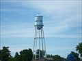
|   Watertower, Bonesteel, South Dakota Watertower, Bonesteel, South Dakota
in Water Towers Small town watertower. Elevation 1977 posted by:  NGComets NGComets location: South Dakota date approved: 08/03/2013 last visited: never |
 view gallery view gallery SW12.4 km SW12.4 km
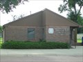
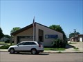
|  Bonesteel, South Dakota 57317 Bonesteel, South Dakota 57317
in U.S. Post Offices Small town post office. Elevation 1965 posted by: NGComets location: South Dakota date approved: 08/15/2013 last visited: never |
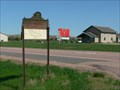
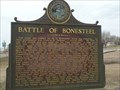 view gallery view gallerySW12.7 km |  Battle of Bonesteel Battle of Bonesteel
in South Dakota Historical Markers Battle of Bonesteel to rid the thugs controlling town. posted by: plainsdrifter358 location: South Dakota date approved: 04/02/2006 last visited: 06/19/2007 |
 view gallery view gallery S15 km S15 km
| Fairfax, South Dakota 57335 in U.S. Post Offices Small town post office with an elevation of 1950 feet. posted by: NGComets location: South Dakota date approved: 08/02/2013 last visited: never |
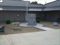 view gallery view galleryS15 km |  Veterans Memorial, Fairfax, South Dakota Veterans Memorial, Fairfax, South Dakota
in Non-Specific Veteran Memorials Outstanding veterans memorial in a small town in Gregory County. Elevation 1952 posted by: NGComets location: South Dakota date approved: 10/26/2013 last visited: never |
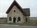
 view gallery view galleryS16.7 km | Bethlehem German Congregational Church in South Dakota Historical Markers Old Stone Church first erected 1893 near Bonesteel, SD posted by: plainsdrifter358 location: South Dakota date approved: 04/02/2006 last visited: 06/19/2007 |
 view gallery view gallerySE20.1 km |  NE-SD on US 281 NE-SD on US 281
in Border Crossings A quite border crossing on US Hwy 281 between Nebraska and South Dakota on a 2-lane highway. posted by: PeterNoG location: South Dakota date approved: 04/27/2011 last visited: 08/30/2012 |
 view gallery view gallery NW20.3 km NW20.3 km
|  Platte Creek State Rec Area in South Dakota Platte Creek State Rec Area in South Dakota
in Campgrounds Platte Creek Rec Area on the Missouri River in South Kakota posted by: plainsdrifter358 location: South Dakota date approved: 03/06/2006 last visited: never |
 view gallery view gallery E24.1 km E24.1 km
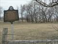
| CCC Camp BF-1 at Lake Andes National Wildlife Refuge in South Dakota Historical Markers CCC Camp established for drought relief during the Great Depression worked on what is now the Lake Andes National Wildlife Refuge posted by: plainsdrifter358 location: South Dakota date approved: 05/21/2006 last visited: 06/21/2007 |
 view gallery view galleryE24.1 km | Historic Highway ~ South to Pickstown in South Dakota Historical Markers Located in Lake Andes SD on Highway 44. posted by: MNSearchers location: South Dakota date approved: 06/27/2007 last visited: 06/22/2007 |
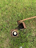
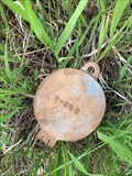
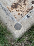
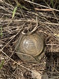 view gallery view galleryE24.9 km |  CA 1/1 (OR0255) - Lake Andes, SD CA 1/1 (OR0255) - Lake Andes, SD
in U.S. Benchmarks Bronze colored survey disk posted by: CampDoggs location: South Dakota date approved: 06/30/2022 last visited: never |
 view gallery view gallery N25.3 km N25.3 km
| Watertower, Platte, South Dakota in Water Towers Small town watertower. posted by: NGComets location: South Dakota date approved: 07/29/2011 last visited: never |
 view gallery view galleryN25.3 km |  "American Legion Post 115" Platte, South Dakota "American Legion Post 115" Platte, South Dakota
in Legion Posts and Branches Named for two area men, Campbell and Timmerman. posted by: NGComets location: South Dakota date approved: 07/29/2011 last visited: never |
 view gallery view galleryN25.3 km | Platte, South Dakota 57369 in U.S. Post Offices Small town post office. posted by: NGComets location: South Dakota date approved: 07/30/2011 last visited: never |
 view gallery view gallerySE25.4 km |  Fort Randall Eagle Roost Fort Randall Eagle Roost
in U.S. National Natural Landmarks Fort Randall Eagle Roost NNL at Randall Creek Recreation Area, Fort Randall Hydroelectric Dam, and the town of Pickstown, SD posted by: plainsdrifter358 location: South Dakota date approved: 07/08/2006 last visited: 06/11/2006 |
 view gallery view galleryE25.4 km | J 336 (OR0257) - Pickstown, SD in U.S. Benchmarks Benchmark disk set in concrete. posted by: CampDoggs location: South Dakota date approved: 06/30/2022 last visited: never |
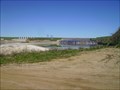 view gallery view gallerySE25.6 km |  Ft. Randall Dam - Pickstown, SD Ft. Randall Dam - Pickstown, SD
in Water Dams Ft. Randall Dam on the Missouri River just west of Pickstown, SD posted by: dbrockhouse location: South Dakota date approved: 02/25/2011 last visited: 10/20/2015 |
 view gallery view gallerySE25.7 km | Fort Randall & Old Church in South Dakota Historical Markers Fort Randall on Missouri River in SD, a Calvary Fort first established in 1856. posted by: plainsdrifter358 location: South Dakota date approved: 04/02/2006 last visited: 10/20/2015 |
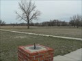 view gallery view gallerySE25.9 km |  Fort Randall, SD Sun Dial Fort Randall, SD Sun Dial
in Sundials This sundial is located at the center of the parade grounds of Fort Randall, SD established in 1856 posted by: plainsdrifter358 location: South Dakota date approved: 04/02/2006 last visited: 10/20/2015 |
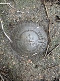
 view gallery view galleryE26.2 km | 4 (OR1139) - Pickstown, SD in U.S. Benchmarks Pipe encased in PVC, iron cap. posted by: CampDoggs location: South Dakota date approved: 06/30/2022 last visited: never |
 view gallery view galleryE26.2 km | DON (OR1140) - Pickstown, SD in U.S. Benchmarks Pipe encased inside a galvanized pipe. posted by: CampDoggs location: South Dakota date approved: 06/30/2022 last visited: never |
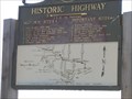
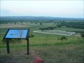
 view gallery view galleryE27 km | Historic Highway ~ 2 blocks S then E in South Dakota Historical Markers Map of 1856 highway from Yankton to Pickstown along the Missouri River. posted by: plainsdrifter358 location: South Dakota date approved: 05/21/2006 last visited: 04/28/2013 |
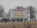
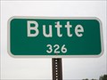 view gallery view galleryS27 km |  Butte, Nebraska - Population 326 Butte, Nebraska - Population 326
in Population Signs Small town at the junction of Nebraska Highways 11 and 12.
Elevation 1790. posted by: NGComets location: Nebraska date approved: 12/17/2017 last visited: never |
 view gallery view gallerySE27.2 km | 1005 (OR0263) - Pickstown, SD in U.S. Benchmarks Bolt set in concrete. posted by: CampDoggs location: South Dakota date approved: 06/30/2022 last visited: never |
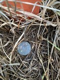
 view gallery view galleryS27.4 km | Y 19 (NN0285) - Butte, NE in U.S. Benchmarks Benchmark disk set into concrete at ground level. posted by: CampDoggs location: Nebraska date approved: 03/18/2022 last visited: never |
|