 view gallery view gallery N3.2 km N3.2 km
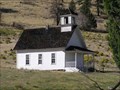
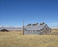
|   Harris School, Summer Lake, OR, USA Harris School, Summer Lake, OR, USA
in Former Schools Picturesque one-room school which served the Summer Lake area. posted by:  Volcanoguy Volcanoguy location: Oregon date approved: 10/02/2007 last visited: 10/02/2007 |
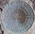
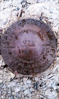
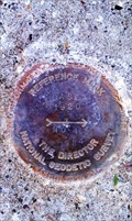
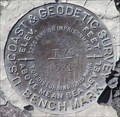 view gallery view galleryN4.2 km |  NY0186 - USCGS T72, OR NY0186 - USCGS T72, OR
in U.S. Benchmarks U.S. Coast & Geodetic Survey bench mark T72. posted by: Volcanoguy location: Oregon date approved: 09/30/2007 last visited: 09/30/2007 |
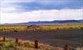
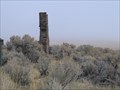 view gallery view galleryN5.8 km |  Lonely Chimney near Summer Lake, Oregon Lonely Chimney near Summer Lake, Oregon
in Lonely Chimneys Lonely chimney somewhere along Highway 31 in Oregon posted by:  fishingwishing fishingwishing location: Oregon date approved: 12/29/2008 last visited: never |
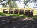 view gallery view galleryN8.4 km |  Outback Scenic Byway - Jack Lake Interpretive Site Outback Scenic Byway - Jack Lake Interpretive Site
in National Scenic Byways Scenic Byway Interpretive Site at the Jack Lake. posted by: Volcanoguy location: Oregon date approved: 05/25/2008 last visited: 05/25/2008 |
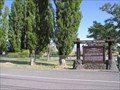
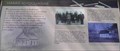 view gallery view galleryN8.4 km |  Harris Schoolhouse Harris Schoolhouse
in Oregon Historical Markers Two of the six signs at this location. posted by: Volcanoguy location: Oregon date approved: 10/01/2007 last visited: 10/01/2007 |
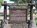 view gallery view galleryN10.5 km | Fremont Memorial in Oregon Historical Markers The Fremont Memorial at Summer Lake posted by: Volcanoguy location: Oregon date approved: 10/01/2007 last visited: 10/01/2007 |
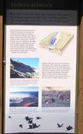 view gallery view galleryN10.5 km | Broken Bedrock in Oregon Historical Markers Two of the four signs at this kiosk at the Summer Lake Rest Area. posted by: Volcanoguy location: Oregon date approved: 10/01/2007 last visited: 10/01/2007 |
 view gallery view galleryN10.5 km | Outback Scenic Byway - Summer Lake Interpretive Site in National Scenic Byways Scenic Byway Interpretive Kiosk at the Summer Lake Rest Area. posted by: Volcanoguy location: Oregon date approved: 05/25/2008 last visited: 05/25/2008 |
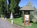
 view gallery view galleryN10.5 km |  Summer Lake Rest Area, Oregon Summer Lake Rest Area, Oregon
in Highway Rest Areas The Summer Lake Rest Area on Ore. Hwy. 31. posted by: Volcanoguy location: Oregon date approved: 10/01/2007 last visited: 10/01/2007 |
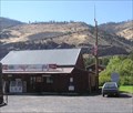 view gallery view galleryN10.5 km |  Summer Lake, OR, 97640 Summer Lake, OR, 97640
in U.S. Post Offices The Summer Lake, OR Post Office. posted by: Volcanoguy location: Oregon date approved: 09/29/2007 last visited: 09/29/2007 |
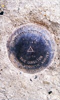
 view gallery view galleryN14.6 km | PB0599 - USCGS W72, OR in U.S. Benchmarks U.S. Coast & Geodetic Survey bench mark W72. posted by: Volcanoguy location: Oregon date approved: 09/30/2007 last visited: 09/30/2007 |
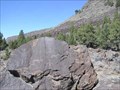
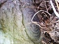
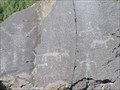 view gallery view galleryN18.3 km |  Picture Rock Pass Petroglyphs, OR Picture Rock Pass Petroglyphs, OR
in Pictographs Petroglyphs at Picture Rock Pass on Ore. Hwy. 31 posted by: Volcanoguy location: Oregon date approved: 10/01/2007 last visited: 10/10/2014 |
 view gallery view galleryN18.3 km |  Picture Rock Pass Petroglyphs Site Picture Rock Pass Petroglyphs Site
in U.S. National Register of Historic Places Petroglyph site at Picture Rock Pass on Ore. Hwy. 31 posted by: Volcanoguy location: Oregon date approved: 11/13/2007 last visited: 11/13/2007 |
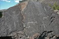 view gallery view galleryN18.3 km | Picture Rock - Outback Scenic Byway - Oregon in National Scenic Byways Picture Rock Pass is located along Central Oregon's "Outback" and is named for the petroglyphs that can be found on the volcanic rocks that are within walking distance of the road. posted by: Hikenutty location: Oregon date approved: 09/08/2008 last visited: 09/30/2012 |
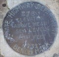 view gallery view galleryN18.3 km | PB0590 - OSHD E73, OR in U.S. Benchmarks Oregon State Highway Department bench mark E73. posted by: Volcanoguy location: Oregon date approved: 09/30/2007 last visited: 09/30/2007 |
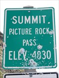 view gallery view galleryN18.3 km |  Picture Rock Pass - 4830' Picture Rock Pass - 4830'
in Elevation Signs Highway 31 between Silver Lake and Summer Lake. posted by: WR7X location: Oregon date approved: 05/25/2013 last visited: never |
 view gallery view gallery SE22.4 km SE22.4 km
|  Summer Lake Hot Springs - Summer Lake, OR Summer Lake Hot Springs - Summer Lake, OR
in Hot Springs Hot springs in an old 'cowboy bathhouse'... posted by: fishingwishing location: Oregon date approved: 03/12/2008 last visited: 06/07/2021 |
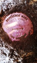
 view gallery view gallerySE23.5 km | NY0198 - USCGS 'J 72' BM - Lake County, OR in U.S. Benchmarks This NGS benchmark is located just off Hwy 31 in Lake County, OR. posted by: NW_history_buff location: Oregon date approved: 08/31/2013 last visited: never |
 view gallery view gallerySE23.5 km | NY0985 - NGS 'WORLOW RESET' Horizontal Control Mark - Lake County, OR in U.S. Benchmarks This NGS control mark is located just north of Hwy 31 in Lake County, OR. posted by: NW_history_buff location: Oregon date approved: 09/03/2013 last visited: never |
 view gallery view gallerySE23.5 km | CD8886 - NGS Reference Mark 1 - Lake County, OR in U.S. Benchmarks This NGS reference mark is located just north of Hwy 31 in Lake County, OR. posted by: NW_history_buff location: Oregon date approved: 09/03/2013 last visited: never |
 view gallery view gallerySE28.3 km |  Paisley State Airport - Paisley, OR Paisley State Airport - Paisley, OR
in Airports The Paisley State Airport is located a couple of miles NW of Paisley, OR. posted by: NW_history_buff location: Oregon date approved: 09/20/2013 last visited: 06/07/2021 |
 view gallery view gallerySE29.6 km | NY0200 - Reference Mark 4 - Lake County, OR in U.S. Benchmarks This NGS Reference Mark is located just west of the junction of Hwy 31 and Red House Rd in Lake County, OR. posted by: NW_history_buff location: Oregon date approved: 08/27/2013 last visited: never |
 view gallery view gallerySE29.6 km | NY0200 - Reference Mark 5 - Lake County, OR in U.S. Benchmarks This NGS Reference Mark is located just west of the junction of Hwy 31 and Red House Rd in Lake County, OR. posted by: NW_history_buff location: Oregon date approved: 08/27/2013 last visited: never |
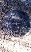 view gallery view gallerySE29.8 km |  NY0200 - USCGS Azimuth Mark - Lake County, OR NY0200 - USCGS Azimuth Mark - Lake County, OR
in Azimuth Benchmarks This NGS mark is located just north of Red House Rd in Lake County, OR. posted by: NW_history_buff location: Oregon date approved: 08/30/2013 last visited: never |
 view gallery view gallerySE29.8 km | NY0200 - USCGS Azimuth Mark - Lake County, OR in U.S. Benchmarks This NGS mark is located just north of Red House Rd in Lake County, OR. posted by: NW_history_buff location: Oregon date approved: 08/27/2013 last visited: never |
|