 view gallery view gallery E10.6 km E10.6 km
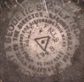
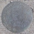
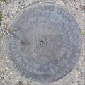
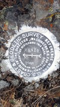
|   NY0793 - USCGS VALLEY FALLS, OR NY0793 - USCGS VALLEY FALLS, OR
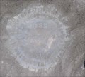
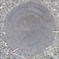
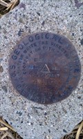
in U.S. Benchmarks USCGS Triangulation Station VALLEY FALLS. posted by:  Volcanoguy Volcanoguy location: Oregon date approved: 10/17/2007 last visited: 10/17/2007 |
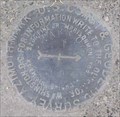
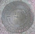
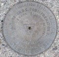
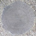
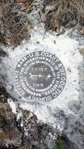
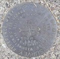 view gallery view galleryE10.6 km | NY0793 - USCGS VALLEY FALLS NO 5, OR in U.S. Benchmarks USCGS Reference Mark VALLEY FALLS NO 5. posted by: Volcanoguy location: Oregon date approved: 10/17/2007 last visited: 10/17/2007 |
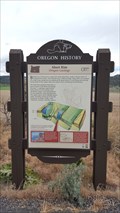 view gallery view galleryE10.9 km |  Abert Rim (Hwy 31) Abert Rim (Hwy 31)
in Oregon Historical Markers Oregon Geology Marker about Abert Rim on Ore. Hwy. 31. *UPDATE 6/4/17* This Beaver Board has been replaced and relocated to the west side of the highway and further south from the original. New coordinates updated. posted by: Volcanoguy location: Oregon date approved: 10/16/2007 last visited: 06/04/2017 |
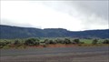 view gallery view galleryE10.9 km |  Abert Rim - Oregon Geology - Lake County, OR Abert Rim - Oregon Geology - Lake County, OR
in Places of Geologic Significance A historical 'Beaver Board' located just of US 395 highlights the geological history of nearby Abert Rim. posted by: NW_history_buff location: Oregon date approved: 06/15/2017 last visited: never |
 view gallery view gallery NE11.1 km NE11.1 km
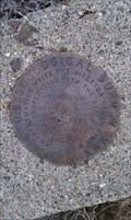
| ODOT V 597, OR in U.S. Benchmarks ODOT benchmark on Chewaucan River bridge. posted by: Volcanoguy location: Oregon date approved: 10/17/2007 last visited: 10/17/2007 |
 view gallery view gallery N11.1 km N11.1 km
| NY0755 - USCGS NARROWS AZI MK, OR in U.S. Benchmarks USCGS Azimuth Mark NARROWS. posted by: Volcanoguy location: Oregon date approved: 10/17/2007 last visited: 10/17/2007 |
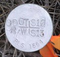 view gallery view galleryNE11.1 km | ODOT R/W 12/13, OR in U.S. Benchmarks ODOT Right of Way Mark on Section Line between Sections 12 & 13. posted by: Volcanoguy location: Oregon date approved: 10/17/2007 last visited: 10/17/2007 |
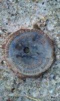
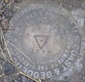
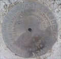 view gallery view galleryNE11.1 km | NY0754 - USCGS CHEWAUCAN, OR in U.S. Benchmarks USCGS Triangulation Station CHEWAUCAN. posted by: Volcanoguy location: Oregon date approved: 10/15/2007 last visited: 10/16/2007 |
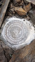
 view gallery view galleryN11.3 km | NY0755 - USCGS NARROWS, OR in U.S. Benchmarks USCGS Triangulation Station NARROWS. posted by: Volcanoguy location: Oregon date approved: 10/16/2007 last visited: 10/16/2007 |
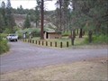 view gallery view gallery SE12.9 km SE12.9 km
|  Chandler State Wayside - Oregon Chandler State Wayside - Oregon
in State/Provincial Parks This wayside park is located along U.S. Hwy. 395 about 15 miles north of Lakeview, Oregon. posted by: Volcanoguy location: Oregon date approved: 10/26/2007 last visited: 03/03/2013 |
 view gallery view gallerySE13.2 km | NY0105 - USCGS Q375, OR in U.S. Benchmarks USCGS Benchmark Q375 posted by: Volcanoguy location: Oregon date approved: 10/19/2007 last visited: 03/03/2013 |
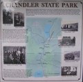 view gallery view gallerySE13.2 km | Chandler State Park in Oregon Historical Markers History sign at Chandler State Park.
posted by: Volcanoguy location: Oregon date approved: 10/17/2007 last visited: 03/03/2013 |
 view gallery view galleryN14.3 km | NY0756 - USCGS MOSS NO 1, OR in U.S. Benchmarks USCGS Reference Mark MOSS NO 1. posted by: Volcanoguy location: Oregon date approved: 10/15/2007 last visited: 03/03/2013 |
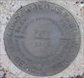
 view gallery view galleryN14.3 km | NY0756 - USCGS MOSS, OR in U.S. Benchmarks USCGS Triangulation Station MOSS. posted by: Volcanoguy location: Oregon date approved: 10/15/2007 last visited: 03/03/2013 |
 view gallery view galleryN14.3 km | NY0756 - MOSS Reference Mark 3 - Lake County, OR in U.S. Benchmarks This NGS reference mark lies along Hwy 31 and directly across the road from the MOSS series of benchmarks in Lake County, OR. posted by: NW_history_buff location: Oregon date approved: 03/08/2013 last visited: never |
 view gallery view gallerySE14.3 km | NY0102 - USCGS P375, OR in U.S. Benchmarks USCGS Benchmark P375. posted by: Volcanoguy location: Oregon date approved: 10/20/2007 last visited: 10/20/2007 |
 view gallery view gallerySE14.3 km | NY0795 - USCGS DICK NO 2, OR in U.S. Benchmarks USCGS Reference Mark DICK NO 2 posted by: Volcanoguy location: Oregon date approved: 10/19/2007 last visited: 10/20/2007 |
 view gallery view gallerySE14.3 km | NY0795 - USCGS DICK NO 1, OR in U.S. Benchmarks USCGS Reference Mark DICK NO 1. posted by: Volcanoguy location: Oregon date approved: 10/19/2007 last visited: 10/20/2007 |
 view gallery view gallerySE14.3 km | NY0795 - USCGS DICK, OR in U.S. Benchmarks USCGS Triangulation Station DICK. posted by: Volcanoguy location: Oregon date approved: 10/19/2007 last visited: 10/20/2007 |
 view gallery view gallery NW15 km NW15 km
| NY0835 - USC&GS 'ENNIS' Triangulation Station - Lake County, OR in U.S. Benchmarks This NGS station is located on top of a small butte/mountain south of Paisley. posted by: NW_history_buff location: Oregon date approved: 06/10/2017 last visited: never |
 view gallery view galleryNW15 km | NY0835 - USC&GS 'ENNIS RM 1' Reference Mark - Lake County, OR in U.S. Benchmarks This NGS reference mark is located atop a small mountain/butte a few miles south of Paisley. posted by: NW_history_buff location: Oregon date approved: 06/10/2017 last visited: never |
 view gallery view galleryNW15 km | NY0835 - USC&GS 'ENNIS RM 2' Reference Mark - Lake County, OR in U.S. Benchmarks This NGS reference mark is located atop a small mountain/butte a few miles south of Paisley. posted by: NW_history_buff location: Oregon date approved: 06/10/2017 last visited: never |
 view gallery view galleryN16.7 km | USGS '5 DOR 1963' BM - Lake County, OR in U.S. Benchmarks This benchmark lies between two dirt roads (possibly on private property) and north of Hwy 31 in Lake County, OR. posted by: NW_history_buff location: Oregon date approved: 03/11/2013 last visited: never |
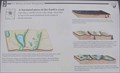 view gallery view galleryE17.4 km | A fractured piece of the Earth’s crust in Oregon Historical Markers One of three signs about the Abert Rim and Abert Lake area on U.S. Hwy. 395. posted by: Volcanoguy location: Oregon date approved: 10/16/2007 last visited: 08/16/2019 |
 view gallery view galleryN19.5 km | USGS '4 DOR 1963' BM - Lake County, OR in U.S. Benchmarks This benchmark lies just east of a dirt road (possibly on private property) and north of Hwy 31 in Lake County, OR. posted by: NW_history_buff location: Oregon date approved: 03/11/2013 last visited: never |
|