 view gallery view gallery NW2.6 km NW2.6 km
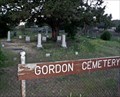
|   Gordon Cemetery - Klamath County, OR Gordon Cemetery - Klamath County, OR
in Worldwide Cemeteries This small cemetery sits just off of Keno-Worden Rd in the former community of Worden, OR. posted by:  NW_history_buff NW_history_buff location: Oregon date approved: 07/23/2012 last visited: never |
 view gallery view gallery W2.6 km W2.6 km
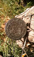
|  T40S R8E SEC 33,34 T41S SEC 3,4 - Worden, OR T40S R8E SEC 33,34 T41S SEC 3,4 - Worden, OR
in Public Land Survey Marks This section corner from 1919 exists in front of a turn-of-the-century home in the community formally known as Worden, OR. posted by: NW_history_buff location: Oregon date approved: 07/27/2012 last visited: never |
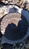
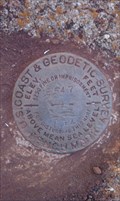
 view gallery view galleryW2.6 km |  USGLO T40S R8E SEC 33,34 T41S SEC 3,4 - Worden, OR USGLO T40S R8E SEC 33,34 T41S SEC 3,4 - Worden, OR
in U.S. Benchmarks This section corner from 1919 exists in front of a turn-of-the-century home in the community formally known as Worden, OR. posted by: NW_history_buff location: Oregon date approved: 10/15/2013 last visited: never |
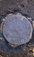
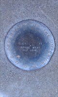
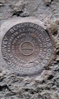
 view gallery view galleryNW2.7 km | NY0422 - USC&GS 'G 547' BM - Klamath County, OR in U.S. Benchmarks This NGS benchmark is located on top of a low-lying boulder just east of some railroad tracks in Klamath County, OR. posted by: NW_history_buff location: Oregon date approved: 12/16/2012 last visited: never |
 view gallery view galleryW2.9 km | NY0419 - USGS 'AX 6' BM - Klamath County, OR in U.S. Benchmarks This NGS benchmark exists on top of a boulder and under a juniper tree on private property just south of Bear Valley Rd. in Klamath County, OR. posted by: NW_history_buff location: Oregon date approved: 10/01/2012 last visited: never |
 view gallery view gallery N3.5 km N3.5 km
| NY0423 - USC&GS 'H 547' BM - Klamath County, OR in U.S. Benchmarks This NGS benchmark is located at an irrigation canal near Hwy 97 in Klamath County, OR. posted by: NW_history_buff location: Oregon date approved: 10/19/2012 last visited: never |
 view gallery view gallery SW4.2 km SW4.2 km
| DH6553 - CADT '161 SIS 1.14' Metal Cap - Siskiyou County, CA in U.S. Benchmarks This metal cap is located just north of State Line Rd in Siskiyou County, CA. posted by: NW_history_buff location: California date approved: 12/28/2014 last visited: never |
 view gallery view galleryW4.3 km | NY0417 - USC&GS 'E 547' BM - Klamath County, OR in U.S. Benchmarks This NGS benchmark is monumented on top of a headwall of a former railroad underpass along Bear Valley Rd in Klamath County, OR. posted by: NW_history_buff location: Oregon date approved: 10/18/2012 last visited: never |
 view gallery view gallerySW4.8 km |  CA/OR on US Highway 97 CA/OR on US Highway 97
in Border Crossings Northbound travelers crossing from California to Oregon on US Highway 97 are greeted with an artistic metal sculpture featuring an eagle flying at the top of a pine tree. posted by: DougK location: Oregon date approved: 05/07/2010 last visited: 06/21/2014 |
 view gallery view gallerySW4.8 km | MW0622 - USC&GS 'T 508 RESET' BM - Klamath County, OR in U.S. Benchmarks This NGS benchmark is located just west of the parking lot of the Landrum Wayside Rest Area at the Oregon/California border in Klamath County, OR. posted by: NW_history_buff location: Oregon date approved: 12/16/2012 last visited: never |
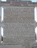
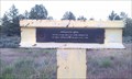 view gallery view gallerySW5 km |  Applegate Trail - Klamath County, OR Applegate Trail - Klamath County, OR
in Oregon Historical Markers This historical marker is located just off Hwy 97 on the left side of the road if you're heading south, near the Oregon/California border in Klamath County, OR. posted by: NW_history_buff location: Oregon date approved: 06/12/2012 last visited: 08/04/2013 |
 view gallery view gallerySW5 km |  AppleGate Trail - Oregon AppleGate Trail - Oregon
in Wagon Roads and Trails At the Frances S. Landrum Historic Wayside in Oregon, you can stand on the old Applegate Trail. posted by: DougK location: Oregon date approved: 09/13/2010 last visited: 08/04/2013 |
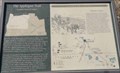 view gallery view gallerySW5 km | The Applegate Trail in Oregon Historical Markers History sign about the Applegate Trail at Landrum Wayside. posted by: Volcanoguy location: Oregon date approved: 11/07/2012 last visited: 08/04/2013 |
 view gallery view gallerySW5 km | Western International History -- Applegate Trail in Oregon Historical Markers History sign about the Applegate Trail at Landrum Wayside. posted by: Volcanoguy location: Oregon date approved: 11/07/2012 last visited: 08/04/2013 |
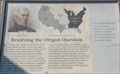 view gallery view gallerySW5 km | Resolving the Oregon Question in Oregon Historical Markers History sign about the Applegate Trail at Landrum Wayside. posted by: Volcanoguy location: Oregon date approved: 11/07/2012 last visited: 08/04/2013 |
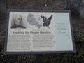 view gallery view gallerySW5 km |  Resolving the Oregon Question - Oregon Resolving the Oregon Question - Oregon
in Signs of History At the Frances S. Landrum Historic Wayside in Oregon, There are signs discussing the history of settlers in Oregon. posted by: DougK location: Oregon date approved: 09/14/2010 last visited: 08/04/2013 |
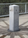 view gallery view gallerySW5 km |  42nd Parallel Survey Marker - Oregon 42nd Parallel Survey Marker - Oregon
in U.S. Historic Survey Stones and Monuments At the Frances S. Landrum Historic Wayside in Oregon, is a stone marker on the 42nd parallel. This point was first surveyed on July 4, 1846. posted by: DougK location: Oregon date approved: 09/13/2010 last visited: 08/04/2013 |
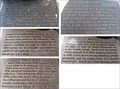 view gallery view gallerySW5 km | 42nd Parallel Monument in Oregon Historical Markers History signs related to 42nd Parallel Monument at Landrum Wayside. posted by: Volcanoguy location: Oregon date approved: 11/07/2012 last visited: 08/04/2013 |
 view gallery view gallerySW5 km |  42nd Parallel North - Landrum Wayside, Oregon 42nd Parallel North - Landrum Wayside, Oregon
in Great Lines of Earth A 42nd Parallel Monument at Francis S. Landrum Historic Wayside. posted by: Volcanoguy location: Oregon date approved: 11/07/2012 last visited: 08/04/2013 |
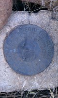
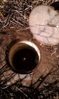 view gallery view galleryNW5 km | NY0734 - NGS 'C 785' Metal Rod - Klamath County, OR in U.S. Benchmarks This NGS metal rod is located just off Wordon Rd in Klamath County, OR. posted by: NW_history_buff location: Oregon date approved: 10/02/2012 last visited: never |
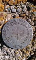
 view gallery view galleryN5.1 km | Klamath Reclamation Project Pumping Station - Klamath County, OR in U.S. Benchmarks This US Dept of the Interior benchmark is located at the Klamath Reclamation Project Pumping Station, just off of Hwy 97, in Klamath County, OR. posted by: NW_history_buff location: Oregon date approved: 06/27/2012 last visited: never |
 view gallery view gallerySW5.3 km | Siskiyou County Surveyor 'MP 94 1981' Boundary Marker - Siskiyou County, CA in Public Land Survey Marks This state boundary pipe cap divides California and Oregon at the 42nd latitude. posted by: NW_history_buff location: California date approved: 10/04/2015 last visited: never |
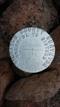 view gallery view gallerySW5.3 km | Siskiyou County Surveyor 'MP 94 1981' Boundary Marker - Siskiyou County, CA in U.S. Benchmarks This state boundary pipe cap divide California and Oregon at the 42nd latitude. posted by: NW_history_buff location: California date approved: 10/04/2015 last visited: never |
 view gallery view galleryN5.3 km | NY0424 - USC&GS 'C 5' BM - Klamath County, OR in U.S. Benchmarks This NGS tidal benchmark is located along the railroad tracks on top of a concrete abutment spanning an irrigation canal and west of Hwy 97 in Klamath County, OR. posted by: NW_history_buff location: Oregon date approved: 12/16/2012 last visited: never |
 view gallery view galleryN5.3 km | NY0425 - BOR 'BM' Benchmark - Klamath County, OR in U.S. Benchmarks This NGS benchmark is located on top of a concrete abutment to an irrigation canal east of the railroad tracks and west of Hwy 97 in Klamath County, OR. posted by: NW_history_buff location: Oregon date approved: 12/16/2012 last visited: never |
|