 view gallery view gallery W3.1 km W3.1 km
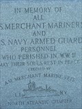
|   Montauk Maritime Memorial Montauk Maritime Memorial
in Maritime Monuments and Memorials This Maritime Memorial is located at Montauk Point Lighthouse. The oldest lighthouse in New York state, authorized under President George Washington in 1792.
posted by:  Old Navy Old Navy location: New York date approved: 09/27/2008 last visited: 03/11/2014 |
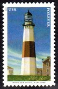 view gallery view galleryW3.1 km |  Montauk Point Light, Montauk, NY Montauk Point Light, Montauk, NY
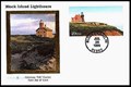
in Philatelic Photographs Montauk Point Lighthouse was one of five mid-Atlantic lighthouses featured on a set of U.S. postage stamps issued in 2021. posted by: hykesj location: New York date approved: 09/11/2021 last visited: 09/30/2023 |
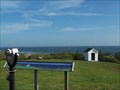 view gallery view galleryW3.2 km |  Bino -Montauk Point Lighthouse Bino -Montauk Point Lighthouse
in Coin-Op Binoculars Montauk Point Lighthouse is a wonderful place to visit. The view from this area to the lighthouse makes it very clear that the facility is well maintained. The most striking feature about the lighthouse is its brightly colored, roof. posted by:  chstress53 chstress53 location: New York date approved: 02/12/2007 last visited: 10/01/2023 |
 view gallery view galleryW3.2 km |  WWII - Montauk Lighthouse WWII - Montauk Lighthouse
in World War II Sites The lighthouse at Montauk has often been the focal point of wartime activities. During World War II, a concrete fire submarine observation tower was built just to the east of the light. If an enemy ship was spotted, the guns would blaze. posted by: chstress53 location: New York date approved: 02/12/2007 last visited: 10/30/2009 |
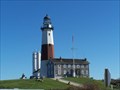 view gallery view galleryW3.2 km |  Montauk Point Lighthouse Montauk Point Lighthouse
in Coastal Lighthouses Montauk Point Lighthouse is a wonderful place to visit. On a clear day you can see Connecticut, Rhode Island, and Block Island. During 1996 Montauk is decked out in its bicentennial year finery. The tower and grounds are now maintained by the Montauk Historical Society, and are open for tours 10 - 5:30. There is a gift shop and a museum with some great exhibits. (516-668-2544) posted by: chstress53 location: New York date approved: 11/03/2005 last visited: 07/25/2019 |
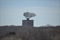 view gallery view galleryW3.5 km |  Camp Hero State Park - Montauk, New York Camp Hero State Park - Montauk, New York
in State/Provincial Parks Montauk Air Force Station, Camp Hero: A World War II and Cold War Relic, now a New York State Park posted by: pkohler01 location: New York date approved: 04/09/2014 last visited: never |
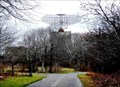 view gallery view galleryW4.7 km |  The Montauk Project The Montauk Project
in Urban Legends and Superstitions The Montauk Project is an alleged series of secret United States government projects conducted at Camp Hero or Montauk Air Force Station on Montauk, Long Island for the purpose of developing psychological warfare techniques. posted by: pkohler01 location: New York date approved: 04/14/2014 last visited: never |
 view gallery view galleryW11.6 km |  Montauk Train Station - "Eternal Sunshine of the Spotless Mind" Montauk Train Station - "Eternal Sunshine of the Spotless Mind"
in Movie Locations Joel(Jim Carey) meets Clementine(Kate Winslet)at the Montauk Train Station posted by: Doug Mathieson location: New York date approved: 08/07/2010 last visited: 10/17/2010 |
 view gallery view gallery NE22.4 km NE22.4 km
|  78 ft - Fresh Pond - Historical Marker - New Shoreham, RI 78 ft - Fresh Pond - Historical Marker - New Shoreham, RI
in Elevation Signs Fresh Pond, now the auxiliary reservoir to New Shoreham's water supply, sits in a knoll a whole 78 ft high and about 3000 ft north of the sea itself. posted by: NorStar location: Rhode Island date approved: 11/14/2017 last visited: never |
 view gallery view galleryNE22.4 km |  Fresh Pond - New Shoreham, RI Fresh Pond - New Shoreham, RI
in Rhode Island Historical Markers Fresh Pond was where original settlers of the island lived in caves and shelters, starting in 1661. posted by: NorStar location: Rhode Island date approved: 11/13/2017 last visited: never |
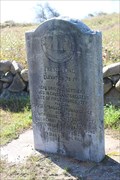
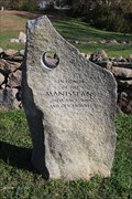 view gallery view galleryNE22.4 km |  Indian Burial Ground - New Shoreham, RI Indian Burial Ground - New Shoreham, RI
in Worldwide Cemeteries This burial ground contains graves of people from the Manisseans tribe who lived on the island. posted by: NorStar location: Rhode Island date approved: 11/17/2017 last visited: 06/22/2022 |
 view gallery view gallery E23.8 km E23.8 km
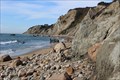
|  Mohegan Bluffs - New Shoreham, RI Mohegan Bluffs - New Shoreham, RI
in Wikipedia Entries Mohegan Bluffs are 150 ft clay cliffs along the southeast shore of Block Island. posted by: NorStar location: Rhode Island date approved: 12/04/2017 last visited: never |
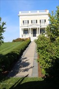 view gallery view galleryNE23.8 km |  U.S. Weather Service Bureau and Radio Station - New Shoreham, RI U.S. Weather Service Bureau and Radio Station - New Shoreham, RI
in American Guide Series For a time, these operations were housed in the wood-framed house, providing weather information important for fishermen. posted by: NorStar location: Rhode Island date approved: 11/13/2017 last visited: never |
 view gallery view galleryE23.8 km | Mohegan Bluffs - New Shoreham, RI in American Guide Series Mohegan Bluffs rise 200 ft above the ocean an extend for five miles along the south shore of Block Island. posted by: NorStar location: Rhode Island date approved: 11/10/2017 last visited: never |
 view gallery view galleryE23.8 km |  Mohegan Bluffs Stairway - New Shoreham, RI Mohegan Bluffs Stairway - New Shoreham, RI
in Outdoor Stairways These stairs take you from the top of Mohegan Bluffs to the beach along the southern shore of Block Island. posted by: NorStar location: Rhode Island date approved: 11/07/2017 last visited: never |
 view gallery view galleryNE23.8 km |  Former Block Island Weather Bureau Station - New Shoreham, RI Former Block Island Weather Bureau Station - New Shoreham, RI
in Weather Stations This building was built specifically for the U.S. Weather Bureau from posted by: NorStar location: Rhode Island date approved: 12/11/2017 last visited: never |
 view gallery view galleryNE23.8 km |  US Weather Bureau Station - New Shoreham, RI US Weather Bureau Station - New Shoreham, RI
in U.S. National Register of Historic Places This building was once the weather station for Block Island. posted by: NorStar location: Rhode Island date approved: 11/10/2017 last visited: never |
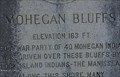 view gallery view galleryE24.1 km | 163 Ft - Mohegan Bluffs Sign - New Shoreham, RI in Elevation Signs 163 is a typical elevation from the top of Mohegan Bluffs to the ocean below a couple hundred feet away. posted by: NorStar location: Rhode Island date approved: 11/15/2017 last visited: never |
 view gallery view galleryE24.1 km | Mohegan Bluffs - New Shoreham, RI in Rhode Island Historical Markers Mohegan Bluffs at Southeast Point rises over 163 ft above the ocean and is near the locations of many ship wrecks. posted by: NorStar location: Rhode Island date approved: 11/21/2017 last visited: never |
 view gallery view galleryE24.1 km |  Shipwrecks Off Mohegan Bluffs - New Shoreham, RI Shipwrecks Off Mohegan Bluffs - New Shoreham, RI
in Shipwrecks A sign by the entrance to the Southeast Lighthouse has a listing of ships that have gone down off Mohegan posted by: NorStar location: Rhode Island date approved: 11/22/2017 last visited: never |
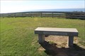 view gallery view galleryE24.1 km |  Catherine Gorayeb Memorial Bench - New Shoreham, RI Catherine Gorayeb Memorial Bench - New Shoreham, RI
in 9/11 Memorial Sites This bench sits in an open space near Southeast Light, and overlooks the Atlantic Ocean. posted by: NorStar location: Rhode Island date approved: 11/10/2017 last visited: 06/21/2022 |
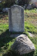
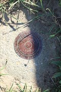 view gallery view galleryE24.1 km |  Survey Disk, BI 001, LW5625 - New Shorham, RI Survey Disk, BI 001, LW5625 - New Shorham, RI
in U.S. Benchmarks The disk is located by a bench and near the Southeast Lighthouse, overlooking Mohegan Bluffs. posted by: NorStar location: Rhode Island date approved: 11/06/2017 last visited: 06/21/2022 |
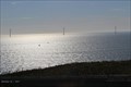 view gallery view galleryE24.1 km |  Block Island Wind Farm - New Shoreham, RI Block Island Wind Farm - New Shoreham, RI
in Windmills This wind farm off the southeast coast is the first commercial offshore wind farm in the United States. posted by: NorStar location: Rhode Island date approved: 11/06/2017 last visited: never |
 view gallery view galleryE24.1 km | Block Island Southeast Light - Block Island, RI in Philatelic Photographs Block Island Southeast Light is one of two historic lighthouses on the island. posted by:  neoc1 neoc1 location: Rhode Island date approved: 08/03/2011 last visited: 09/08/2013 |
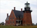 view gallery view galleryE24.1 km | Block Island Southeast Light in Coastal Lighthouses Block Island Southeast Light as it appears today. posted by: StarryEyeGuy location: Rhode Island date approved: 08/22/2006 last visited: 09/08/2013 |
|