 view gallery view gallery NE0.2 km NE0.2 km
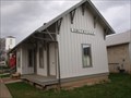
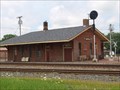
|   Wheeling & Lake Erie Depot - Smithville, Ohio Wheeling & Lake Erie Depot - Smithville, Ohio
in Train Stations/Depots Smithville Depot (1882) - Smithville, Ohio posted by:  buffalohiker buffalohiker location: Ohio date approved: 03/23/2012 last visited: 03/18/2012 |
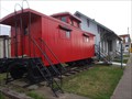 view gallery view galleryNE0.2 km |  Wooden Caboose - Smithville, Ohio Wooden Caboose - Smithville, Ohio
in Train Cabooses A wooden caboose located next to the relocated Smithville Depot in Smithville, Ohio. posted by: buffalohiker location: Ohio date approved: 03/23/2012 last visited: 03/18/2012 |
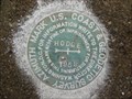
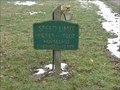 view gallery view galleryNE0.6 km |  Historic John Mishler Weaving Mill : Marker #2-85 Historic John Mishler Weaving Mill : Marker #2-85
in Ohio Historical Markers 381 Mill & 391 Home, E. Main Street in Hydnckr's hometown of Smithville, OH. posted by: BlackBrownDog location: Ohio date approved: 02/13/2006 last visited: 10/11/2009 |
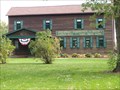 view gallery view galleryNE0.6 km |  John Mishler Weaving Mill - Smithville, Ohio John Mishler Weaving Mill - Smithville, Ohio
in Mills and Gins John Mishler cloth weaving mill in Smithville, Ohio. posted by: buffalohiker location: Ohio date approved: 10/19/2009 last visited: 02/28/2013 |
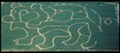 view gallery view gallery SW1 km SW1 km
|  The Barn at Smithville The Barn at Smithville
in Outdoor Mazes Located at The Barn restaurant in Smithville, Oh. posted by: 5hills location: Ohio date approved: 11/18/2009 last visited: never |
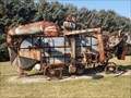 view gallery view gallerySW1 km |  grain separator and manure spreader - Smithville, Ohio grain separator and manure spreader - Smithville, Ohio
in Old Agricultural Equipment Huber Mfg. Co. grain separator with Hart-Carter feeder mechanism and manure spreader at Barn Restaurant in Smithville, Ohio. posted by: buffalohiker location: Ohio date approved: 02/08/2016 last visited: 02/06/2016 |
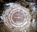
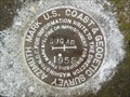
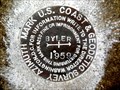 view gallery view galleryNE3.1 km |  CF2690(BYLER AZ MK) - Green Twp Wayne County OH CF2690(BYLER AZ MK) - Green Twp Wayne County OH
in Azimuth Benchmarks This is the azimuth mark for USC&GS triangulation station BYLER, in Green Township, Wayne County. posted by:  shorbird shorbird location: Ohio date approved: 12/24/2014 last visited: never |
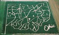 view gallery view gallerySW3.2 km | Ohio Corn Maze - Ramseyer Farm in Outdoor Mazes Located in Wayne County Ohio each year Ramseyer Farm offers two Corm Mazes, one in the shape of the State of Ohio and a mystery maze posted by: 5hills location: Ohio date approved: 11/18/2009 last visited: never |
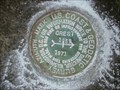
 view gallery view gallery NW5.6 km NW5.6 km
| CC9706(APPLE AZ MK) - Wayne Twp Wayne County OH in Azimuth Benchmarks This is the azimuth mark for USC&GS triangulation station APPLE, in Wayne Township, Wayne County. posted by: shorbird location: Ohio date approved: 12/28/2014 last visited: never |
 view gallery view gallery S6.6 km S6.6 km
| CD1867(HODGE AZ MK) - East Union Twp Wayne County OH in Azimuth Benchmarks This is the azimuth mark for USC&GS triangulation station HODGE. It is in East Union Township, Wayne County. posted by: shorbird location: Ohio date approved: 12/08/2014 last visited: never |
 view gallery view gallery E8.4 km E8.4 km
| Union Depot - Orrville, Ohio in Train Stations/Depots The historic Orrville Union Depot, constructed in
1868 at the crossing of the Cleveland, Akron & Columbus
and Pittsburgh, Ft. Wayne & Chicago Railroads,
serves as the headquarters of Orrville Railroad Heritage Society. posted by: buffalohiker location: Ohio date approved: 11/11/2015 last visited: 07/18/2015 |
 view gallery view gallerySW8.4 km | CREST AZ MK - Ohio in Azimuth Benchmarks This is the azimuth mark for triangulation station CREST, in Wooster Township, Wayne County. posted by: shorbird location: Ohio date approved: 07/03/2010 last visited: never |
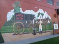 view gallery view galleryE8.4 km |  Smith Dairy murals - Orrville, Ohio Smith Dairy murals - Orrville, Ohio
in Murals Murals depicting the history of Smith Dairy. posted by: buffalohiker location: Ohio date approved: 10/19/2009 last visited: 10/11/2009 |
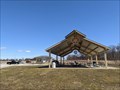 view gallery view gallery W8.5 km W8.5 km
|  Oak Hill Park Pavilion - Wooster, OH Oak Hill Park Pavilion - Wooster, OH
in Rotary International Markers A large Rotary Club gear wheel on a pavilion in Wooster, OH. posted by: TyroneShoelaces location: Ohio date approved: 10/07/2021 last visited: 10/09/2021 |
 view gallery view gallery SE8.7 km SE8.7 km
| CD2186(SUGAR AZ MK) - East Union Twp Wayne County OH in Azimuth Benchmarks This is the azimuth mark for USC&GS triangulation station SUGAR, in East Union Township, Wayne County. posted by: shorbird location: Ohio date approved: 12/09/2014 last visited: never |
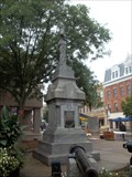 view gallery view gallerySW9.7 km |  Wayne County Civil War Memorial Wayne County Civil War Memorial
in U.S. Civil War Sites This monument depicts a Union soldier with pack and gun at parade rest. The monument faces the courthouse in downtown Wooster, Ohio. posted by: redwolf5 location: Ohio date approved: 09/18/2016 last visited: never |
 view gallery view gallerySW9.7 km |  Wayne County Courthouse - Wooster Ohio Wayne County Courthouse - Wooster Ohio
in Courthouses Wayne County Courthouse - 107 W Liberty St, Wooster Ohio posted by: buffalohiker location: Ohio date approved: 02/08/2016 last visited: 09/17/2016 |
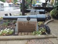 view gallery view gallerySW9.7 km | Pensacola Parrott Guns in U.S. Civil War Sites The site consists of two Parrott Guns from the Civil War Battleship the Pensacola. posted by: redwolf5 location: Ohio date approved: 12/04/2016 last visited: never |
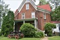 view gallery view galleryNE10.6 km |  Ezekiel Zimmerman octagon house (1883) - Marshallville, Ohio Ezekiel Zimmerman octagon house (1883) - Marshallville, Ohio
in Octagon Buildings Ezekiel Zimmerman octagon house - 10095 Wadsworth Rd (State Route 57), Marshallville, Ohio built 1882-1883. posted by: buffalohiker location: Ohio date approved: 02/15/2016 last visited: 02/06/2016 |
 view gallery view gallerySW10.8 km | CD2176(STATE AZ MK) - Wooster Twp Wayne County OH in Azimuth Benchmarks This is the azimuth mark for USC&GS triangulation station STATE 2, in Wooster Township, Wayne County. posted by: shorbird location: Ohio date approved: 01/06/2015 last visited: never |
 view gallery view gallerySW13.4 km | CD1994(MYERS AZ MK) - Wooster Twp Wayne County OH in Azimuth Benchmarks This is the azimuth mark for USC&GS triangulation station MYERS, in Wooster Township, Wayne County. posted by: shorbird location: Ohio date approved: 01/06/2015 last visited: never |
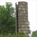 view gallery view galleryNE13.5 km |  Easton Road - Easton Ohio Easton Road - Easton Ohio
in Solitary Silos This silo sits alone in a field. posted by: lp5324 location: Ohio date approved: 09/13/2008 last visited: never |
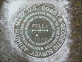 view gallery view gallerySE13.7 km | CD2061(POLLY AZ MK) - Sugar Creek Twp Wayne County OH in Azimuth Benchmarks This is the azimuth mark for USC&GS station POLLY, in Sugar Creek Township, Wayne County. posted by: shorbird location: Ohio date approved: 11/27/2014 last visited: never |
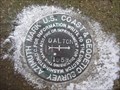 view gallery view gallerySE14.2 km | CC9818(DALTON AZ MK) - Sugar Creek Twp Wayne County OH in Azimuth Benchmarks This is the azimuth mark for USC&GS triangulation station DALTON, in Sugar Creek Township, Wayne County. posted by: shorbird location: Ohio date approved: 12/08/2014 last visited: never |
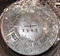 view gallery view galleryNE14.8 km |  NGS Benchmark (KY1711) Doylestown, Ohio NGS Benchmark (KY1711) Doylestown, Ohio
in U.S. Benchmarks National Geodetic Survey benchmark in Doylestown, Ohio that is destroyed per NGS guidelines. posted by: Knight2000 location: Ohio date approved: 04/14/2010 last visited: never |
|