 view gallery view gallery NW0.5 km NW0.5 km
|   Country Lane Covered Bridge - Philadelphia, PA Country Lane Covered Bridge - Philadelphia, PA
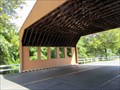
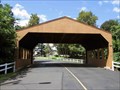
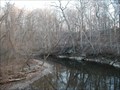
in Satellite Imagery Oddities Who knew? Tucked away in a small private community is a covered bridge with an asphalt road underneath. Although it is of unusual (contemporary) construction for this ilk, it has a cover and crosses a stream. posted by:  Math Teacher Math Teacher location: Pennsylvania date approved: 08/23/2013 last visited: never |
 view gallery view galleryNW0.5 km |  Country Lane Covered Bridge - Philadelphia, PA Country Lane Covered Bridge - Philadelphia, PA
in Covered Bridges Who knew? Tucked away in a small private community is a covered bridge with an asphalt road underneath. Although it is of unusual (contemporary) construction for this ilk, it has a cover and crosses a stream. posted by: Math Teacher location: Pennsylvania date approved: 08/25/2013 last visited: 09/17/2013 |
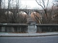
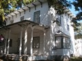
 view gallery view galleryNW0.5 km |  Thomas B. Sanders - Philadelphia, PA Thomas B. Sanders - Philadelphia, PA
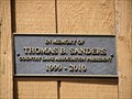
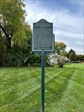
in Citizen Memorials A commemorative plaque on the Country Lane Covered Bridge acknowledges Thomas B. Sanders who was president of the Country Lane Association.
N 40° 05.646 W 075° 02.270 posted by: Math Teacher location: Pennsylvania date approved: 08/25/2013 last visited: never |
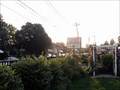
 view gallery view galleryNW1.3 km |  Bustleton, Philadelphia, PA Bustleton, Philadelphia, PA
in Wikipedia Entries Great town were old meets new. "In the early history of the city, Bustleton was known as a rich farming area. Common legend states that the town centered on the Bustleton Tavern, a local bar established before the American Revolution." Wikipedia.com posted by:  mars888 mars888 location: Pennsylvania date approved: 11/29/2013 last visited: 02/04/2014 |
 view gallery view gallery NE1.3 km NE1.3 km
|  First Airmail Delivery - Philadelphia, PA First Airmail Delivery - Philadelphia, PA
in First of its Kind Site of the former Bustleton Field in Philadelphia, where the first regularly scheduled U.S. air mail flight landed on May 15, 1918. posted by: hykesj location: Pennsylvania date approved: 11/05/2022 last visited: never |
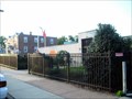
 view gallery view gallery SW2.1 km SW2.1 km
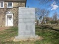
|  Pennepack Baptist Church - Philadelphia PA Pennepack Baptist Church - Philadelphia PA
in Signs of History In the latter half of the seventeenth century, Baptists from England and Wales settled in the County of Philadelphia. Their gathering as posted by: Don.Morfe location: Pennsylvania date approved: 05/09/2020 last visited: 09/26/2021 |
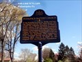 view gallery view gallerySW2.1 km |  Pennepack Baptist Church Pennepack Baptist Church
in Pennsylvania Historical Markers It was founded in 1688 by Welsh and English Baptists led by Rev. Elias Keach who sought the religious freedom of William Penn's colony. posted by: Don.Morfe location: Pennsylvania date approved: 05/29/2020 last visited: 10/19/2021 |
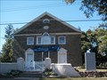 view gallery view gallerySW2.3 km |  Pennypack Baptist Church - Philadelphia PA Pennypack Baptist Church - Philadelphia PA
in This Old Church 325 year old congregation in their 1805 building on the site of earlier buildings dated back to 1705. On historic Krewstown Rd. with a large historic cemetery. posted by: mars888 location: Pennsylvania date approved: 09/21/2013 last visited: 10/21/2013 |
 view gallery view gallery W2.4 km W2.4 km
|  Pennypack Environmental Center Pennypack Environmental Center
in Nature Centers The historic old mill village of Verreeville with 2 old homes, 200' low dam, large meadow with paths, hills & streams, bird blind, museum, friendly staff & much more. posted by: mars888 location: Pennsylvania date approved: 01/01/2014 last visited: 02/08/2014 |
 view gallery view gallerySW2.6 km | Krewstown, NE Philadelphia, PA in Wikipedia Entries "Uses of the name Krewstown include a bridge, a train station, a set of public horse stables, an apartment house complex (Krewstown Park)" Wikipedia.com Very nice 1600 acre park, trails, paths, history & stream at this spot. posted by: mars888 location: Pennsylvania date approved: 12/10/2013 last visited: 02/08/2014 |
 view gallery view gallery SE2.7 km SE2.7 km
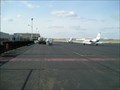
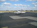
| Northeast Philadelphia Airport in Wikipedia Entries Northeast Philadelphia Airport (IATA: PNE, ICAO: KPNE, FAA LID: PNE) is a public airport located in the Ashton-Woodenbridge neighborhood of Northeast Philadelphia. Northeast Philadelphia Airport is the sixth busiest airport in Pennsylvania. posted by: Math Teacher location: Pennsylvania date approved: 03/16/2008 last visited: 05/27/2013 |
 view gallery view gallerySE2.7 km |  Butterflies @ Northeast Philadelphia Airport - Philadelphia, PA Butterflies @ Northeast Philadelphia Airport - Philadelphia, PA
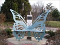
in Insect Sculptures Giant butterfly sculptures abound in this remembrance garden along the entrance to the Northeast Philadelphia Airport. The best thing about these giant butterflies is they double as seats. It is a very beautiful memorial. posted by: Math Teacher location: Pennsylvania date approved: 03/16/2008 last visited: 02/25/2013 |
 view gallery view gallerySE2.7 km |  Northeast Philadelphia Airport - Philadelphia, NJ Northeast Philadelphia Airport - Philadelphia, NJ
in Airports Northeast Philadelphia Airport (IATA: PNE, ICAO: KPNE, FAA LID: PNE) is a public airport located in the Ashton-Woodenbridge neighborhood of Northeast Philadelphia. Northeast Philadelphia Airport is the sixth busiest airport in Pennsylvania. posted by: Math Teacher location: Pennsylvania date approved: 03/16/2008 last visited: 11/24/2013 |
 view gallery view gallery N3.2 km N3.2 km
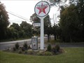
|  Texaco Pump Philadelphia PA Texaco Pump Philadelphia PA
in Vintage Gasoline Pumps A vintage Sky Chief pump on a bucolic stretch of Tomlinson Rd.
On the Front lawn of Petroleum Equipment Inc. posted by: mars888 location: Pennsylvania date approved: 09/18/2013 last visited: 08/28/2013 |
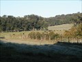 view gallery view galleryW3.5 km | Fox Chase Farm, Philly, PA in Wikipedia Entries Great scenery & walks near parkland used as a farm school. There are a few events each year when you can enjoy the farm grounds & buildings more fully.
The school is nestled between Pennypack Park in Philly & Loimer Park in Montgomery County. posted by: mars888 location: Pennsylvania date approved: 09/21/2013 last visited: 10/21/2013 |
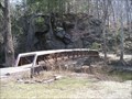
 view gallery view galleryW3.5 km |  Knight's Bridge - Lorimer Park - Abington Twp., PA Knight's Bridge - Lorimer Park - Abington Twp., PA
in Eagle Scout Project Sites This is a very small, pedestrian, covered bridge constructed of wood. It covers a teeny stream bed. It serves no obvious need anymore except for its aesthetic value. It is located in Lorimer Park just over Michael's Foot Bridge and to the right. posted by: Math Teacher location: Pennsylvania date approved: 05/19/2008 last visited: 06/08/2013 |
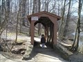 view gallery view galleryW3.5 km | Knight's Bridge - Lorimer Park - Abington Twp., PA in Covered Bridges This is a very small, pedestrian, covered bridge constructed of wood. It covers a teeny stream bed. It serves no obvious need anymore except for its aesthetic value. It is located in Lorimer Park just over Michael's Foot Bridge and to the right. posted by: Math Teacher location: Pennsylvania date approved: 02/18/2010 last visited: 06/08/2013 |
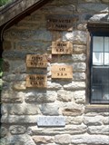 view gallery view galleryW3.5 km |  High Level Markers - Lorimer Park High Level Markers - Lorimer Park
in High Level Marks High level markers in Lorimer Park, Abington, PA posted by: greenducks location: Pennsylvania date approved: 07/12/2012 last visited: 06/08/2013 |
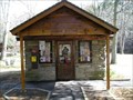 view gallery view galleryW3.5 km |  Lorimer Park - Abington Township, PA Lorimer Park - Abington Township, PA
in Ranger Stations The ranger station is set in the middle of the welcome area of this incredible beautiful park.. I found the park ranger to be very helpful and knowledgeable. He even took a few pictures of my son & I in front of the famous rock outcropping. posted by: Math Teacher location: Pennsylvania date approved: 04/28/2008 last visited: 05/01/2010 |
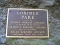 view gallery view galleryW3.5 km | Lorimer Park - Abington Township, PA in Wikipedia Entries Lorimer Park is a 213-acre public park in Abington Township, Pennsylvania. The park, a bequest from the late George Horace Lorimer (Editor-in-Chief of The Saturday Evening Post), is connected to Pennypack Park in Philadelphia County, and the Pennypack Creek runs through both parks. posted by: Math Teacher location: Pennsylvania date approved: 03/31/2008 last visited: 06/08/2013 |
 view gallery view galleryW3.5 km |  Lorimer Park - Abington Township, PA Lorimer Park - Abington Township, PA
in Municipal Parks and Plazas Lorimer Park is a 213-acre public park in Abington Township, Pennsylvania. The park, a bequest from the late George Horace Lorimer (Editor-in-Chief of The Saturday Evening Post), is connected to Pennypack Park in Philadelphia County, and the Pennypack Creek runs through both parks. posted by: Math Teacher location: Pennsylvania date approved: 04/05/2008 last visited: 06/08/2013 |
 view gallery view gallerySW3.5 km |  Bells Corner Toll House on Bustleton Turnpike Bells Corner Toll House on Bustleton Turnpike
in Bygone Toll Houses This was the Bell's Corner toll house of the Bustleton Pike. It was near the intersection of Axe Factory Rd. The Blue Bell Hotel was across the street. Bustleton Pike was laid out in 1697 by John Harper, a Quaker who arrived with William Penn. posted by: mars888 location: Pennsylvania date approved: 09/21/2013 last visited: 10/24/2013 |
 view gallery view gallerySW3.7 km | Rhawnhurst - Philadelphia, PA in Wikipedia Entries Rhawnhurst is a residential neighborhood in the Northeast section of Philadelphia. Once mostly farmland, it is now row homes, a few businesses and several very old houses of worship. There is no noteworthy industry in this neighborhood. posted by: Math Teacher location: Pennsylvania date approved: 07/01/2009 last visited: 06/28/2013 |
 view gallery view gallerySW4 km |  "Rhawnhurst Castor American Legion Post 754" - Philadelphia, PA "Rhawnhurst Castor American Legion Post 754" - Philadelphia, PA
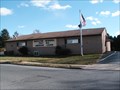
in Legion Posts and Branches Rhawnhurst is a residential neighborhood in the Northeast section of Philly. Similar to surrounding neighborhoods, it has its own post and memorial for its local residents. The memorial sits on the front lawn of this simple, one-story building. posted by: Math Teacher location: Pennsylvania date approved: 06/30/2009 last visited: 05/21/2013 |
 view gallery view gallerySW4 km |  Rhawnhurst-Castor Memorial Post Memorial - Philadelphia, PA Rhawnhurst-Castor Memorial Post Memorial - Philadelphia, PA
in Non-Specific Veteran Memorials This memorial consists of a blue plaque set into a free standing brick wall/facade in front of Rhawnhurst-Castor Memorial Post. This site doubles as Rhawnhurst caterers. This is another residential neighborhood w/ its own identity in Philly. posted by: Math Teacher location: Pennsylvania date approved: 07/01/2009 last visited: 05/21/2013 |
|