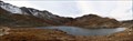
 view gallery view gallery NE2.4 km NE2.4 km
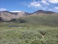
|   Mount Bierstadt Trailhead Mount Bierstadt Trailhead
in Hiking and walking trailheads Mount Bierstadt trailhead is located at 11,065ft above sea level, just off of Guanella Pass. posted by:  Team Laxson Team Laxson location: Colorado date approved: 07/07/2010 last visited: 07/09/2015 |
 view gallery view gallery E5 km E5 km
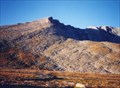
|  Mount Bierstadt Summit Register (14,060) Mount Bierstadt Summit Register (14,060)
in Summit Registers Mount Bierstadt is the 39th tallest peak in Colorado, towering 14,060 feet above sea level. posted by: Team Laxson location: Colorado date approved: 07/06/2010 last visited: 08/16/2020 |
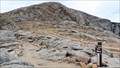
 view gallery view galleryE5 km |  Mount Bierstadt Mount Bierstadt
in Wikipedia Entries Mount Bierstadt is a mountain in the Front Range region of the Rocky Mountains, in Clear Creek County, Colorado. It is one of 54 fourteeners in Colorado. It is located approximately 1.5 miles WSW of Mount Evans. posted by: Team Laxson location: Colorado date approved: 07/08/2010 last visited: 08/16/2020 |
 view gallery view galleryE5 km |  Mount Bierstadt Summit Trail Mount Bierstadt Summit Trail
in Scenic Hikes Mount Bierstadt is the 39th tallest peak in Colorado, towering 14,060 feet posted by: Team Laxson location: Colorado date approved: 07/07/2010 last visited: 09/10/2020 |
 view gallery view galleryE5 km |  Mount Bierstadt Summit (14,060) Mount Bierstadt Summit (14,060)
in Mountain Summits Mount Bierstadt is the 39th tallest peak in Colorado, towering 14,060 feet above sea level. posted by: Team Laxson location: Colorado date approved: 07/06/2010 last visited: 08/16/2020 |
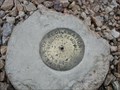
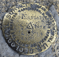 view gallery view galleryE5 km |  KK2029 Bierstadt - Clear Creek County, CO KK2029 Bierstadt - Clear Creek County, CO
in U.S. Benchmarks Survey Disk in Rock Outcrop on the summit of Mount Bierstadt. posted by: animjason location: Colorado date approved: 07/10/2015 last visited: 09/10/2020 |
 view gallery view gallery NW7.1 km NW7.1 km
| US Geological Survey benchmark COLO KII 1924 in U.S. Benchmarks USGS benchmark on Argentine Pass posted by:  jkselby jkselby location: Colorado date approved: 08/13/2009 last visited: never |
 view gallery view galleryE7.2 km | Mount Evans in Mountain Summits A drive-up summit, or an all-day climb! posted by:  Web-ling Web-ling location: Colorado date approved: 10/14/2006 last visited: 07/28/2016 |
 view gallery view galleryE7.4 km | Mount Evans in Wikipedia Entries A drive-up summit, or an all-day climb! posted by: Web-ling location: Colorado date approved: 11/29/2009 last visited: 07/28/2016 |
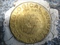
 view gallery view galleryE7.4 km | Mount Evans Benchmark, Colorado in U.S. Benchmarks Near the summit of the mountain which has the highest paved road in the continental US posted by: ronjean location: Colorado date approved: 09/08/2008 last visited: 11/20/2022 |
 view gallery view galleryE7.6 km |  Summit Lake Park 12,830' (3910.5840 m) - Mount Evans, CO Summit Lake Park 12,830' (3910.5840 m) - Mount Evans, CO
in Elevation Signs Summit Lake Park is the highest city park in America. posted by: Outspoken1 location: Colorado date approved: 12/25/2012 last visited: never |
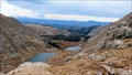
 view gallery view galleryE7.7 km |  Summit Lake, Mt. Evans - Clear Creek County, CO Summit Lake, Mt. Evans - Clear Creek County, CO
in Natural Lakes Summit Lake is found on the drive up the Mount Evans Scenic Byway at nearly 13,000' (3962.4 m). posted by: Outspoken1 location: Colorado date approved: 09/25/2012 last visited: 09/05/2012 |
 view gallery view galleryE7.7 km |  Summit Lake Park - Clear Creek County, CO Summit Lake Park - Clear Creek County, CO
in U.S. National Register of Historic Places Summit Lake is found on the drive up the Mount Evans Scenic Byway at nearly 13,000' (3962.4 m). posted by: Outspoken1 location: Colorado date approved: 09/26/2012 last visited: never |
 view gallery view galleryE7.7 km |  Summit Lake - Clear Creek County, CO Summit Lake - Clear Creek County, CO
in U.S. National Natural Landmarks Summit Lake is found on the drive up the Mount Evans Scenic Byway at nearly 13,000' (3962.4 m). posted by: Outspoken1 location: Colorado date approved: 09/27/2012 last visited: never |
 view gallery view galleryE7.7 km |  Summit Lake Park - Clear Creek County, CO Summit Lake Park - Clear Creek County, CO
in Municipal Parks and Plazas Summit Lake Park is the highest park of the Denver Parks System at nearly 13,000' (3962.4 m). posted by: Outspoken1 location: Colorado date approved: 09/25/2012 last visited: 06/28/2013 |
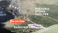
 view gallery view galleryE7.7 km |  Chicago Lakes Basin Overlook, Mt. Evans - Clear Creek County, CO Chicago Lakes Basin Overlook, Mt. Evans - Clear Creek County, CO
in 'You Are Here' Maps This scenic overlook is at nearly 13,000' (3,912 m) near the Summit Lake Park area on the road up Mount Evans. posted by: Outspoken1 location: Colorado date approved: 12/25/2012 last visited: never |
 view gallery view galleryE7.7 km | Mount Evans from Chicago Lake Overlook - Clear Creek County, CO in Hiking and walking trailheads This is one of the many trails to summit Mt. Evans. This trailhead is located at the Summit Lake Park area. posted by: Outspoken1 location: Colorado date approved: 09/25/2012 last visited: 06/28/2013 |
 view gallery view galleryE7.7 km | Chicago Lakes Basin Overlook - Clear Creek County, CO in Scenic Overlooks This scenic overlook is at nearly 13,000' (3,912 m) near the Summit Lake Park area on the road up Mount Evans. posted by: Outspoken1 location: Colorado date approved: 09/25/2012 last visited: never |
 view gallery view galleryE7.7 km | Summit Lake Park, Mt. Evans - Clear Creek County, CO in 'You Are Here' Maps Summit Lake Park is a high alpine tundra city park - it is part of the Denver Mountain Park system. posted by: Outspoken1 location: Colorado date approved: 12/25/2012 last visited: never |
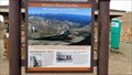 view gallery view galleryE7.7 km |  Summit Lake Park, Mt. Evans - Clear Creek County, CO Summit Lake Park, Mt. Evans - Clear Creek County, CO
in Colorado Historical Markers This series of markers explore flora, fauna and geologic history at Summit Lake Park and nearby Chicago Lakes Basin Overlook. posted by: Outspoken1 location: Colorado date approved: 12/25/2012 last visited: never |
 view gallery view galleryE7.7 km |  HIGHEST -- City Park in America, Denver's Summit Lake Park - Mount Evans, CO HIGHEST -- City Park in America, Denver's Summit Lake Park - Mount Evans, CO
in Superlatives Denver's Mountain Park System includes the highest city park in America - 12,830' (3910.5840 m). It is also the only TREELESS Denver Park. posted by: Outspoken1 location: Colorado date approved: 12/25/2012 last visited: 07/28/2013 |
 view gallery view galleryNW10 km | Grays Peak in Mountain Summits One of the easier Colorado 14ers. posted by: t-xman location: Colorado date approved: 09/10/2005 last visited: 08/19/2010 |
 view gallery view gallery SW10.5 km SW10.5 km
| Bureau of Reclamation - Webster Pass - Colorado in U.S. Benchmarks Bronze disk on a concrete monument at the crest of Webster Pass near Montezuma CO. On the Continental Divide. Cannot find any datasheet for this benchmark, but it is shown on the topo map of the area. posted by: mess50 location: Colorado date approved: 08/03/2007 last visited: 08/30/2016 |
 view gallery view gallery N12.9 km N12.9 km
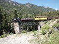
|  Georgetown Loop; Silver Plume Station - Silver Plume, CO Georgetown Loop; Silver Plume Station - Silver Plume, CO
in Scenic Railroads Silver Plume is the western terminus for this historic railroad. posted by: cldisme location: Colorado date approved: 07/03/2010 last visited: 09/27/2019 |
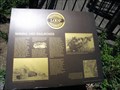 view gallery view galleryN12.9 km | Georgetown Loop Historic Markers - Silver Plume, CO in Colorado Historical Markers This series of marker explores the history of mining, role of geography and nature, in the Georgetown-Silver Plume area. posted by: Outspoken1 location: Colorado date approved: 02/10/2013 last visited: 11/08/2019 |
|