 view gallery view gallery NE0.6 km NE0.6 km
|   Montgomery County AgFair Mural - Gaithersburg MD Montgomery County AgFair Mural - Gaithersburg MD
in Murals The coordinates take you to the Chestnut Avenue gate for the Montgomery County Fairgrounds where this mural can be viewed. It consists of a series of panels representing the themes of the Fairs from 1990 to 1994. posted by:  HaricotVert_52 HaricotVert_52 location: Maryland date approved: 04/19/2009 last visited: 06/13/2010 |
 view gallery view gallery E0.8 km E0.8 km
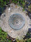
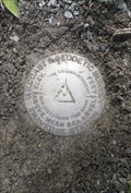
|  GAITHERSBURG OBS MAG STA RESET (JV4127) - Gaithersburg, MD GAITHERSBURG OBS MAG STA RESET (JV4127) - Gaithersburg, MD
in U.S. Benchmarks A Magnetic Station disk located in a park which contains 5 survey marks and is the site of an observatory which was used to measure the wobble of the Earth on its axis. posted by: Ernmark location: Maryland date approved: 05/10/2015 last visited: 05/25/2015 |
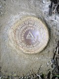 view gallery view galleryE0.8 km | OBSERVATORY (JV4126) - Gaithersburg, MD in U.S. Benchmarks A Triangulation Station disk located in a park which contains 5 survey marks and is the site of an observatory which was used to measure the wobble of the Earth on its axis. posted by: Ernmark location: Maryland date approved: 05/09/2015 last visited: 05/25/2015 |
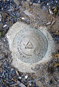 view gallery view galleryE0.8 km | GAITHERSBURG OBS SOUTH (JV2610) - Gaithersburg, MD in U.S. Benchmarks A Traverse Station disk located in a park which contains 5 survey marks and is the site of an observatory which was used to measure the wobble of the Earth on its axis. posted by: Ernmark location: Maryland date approved: 05/10/2015 last visited: 05/25/2015 |
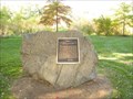
 view gallery view galleryNE0.8 km |  Thomas and Company Cannery - Gaithersburg MD Thomas and Company Cannery - Gaithersburg MD
in U.S. National Register of Historic Places The Thomas Cannery was the first and largest vegetable cannery in Montgomery County, Maryland. It has recently been restored for office and commercial use. posted by: HaricotVert_52 location: Maryland date approved: 05/11/2009 last visited: 06/13/2010 |
 view gallery view galleryE0.8 km | GAITHERSBURG OBS NORTH 2 (JV4125) - Gaithersburg, MD in U.S. Benchmarks A Traverse Station disk located in a park which contains 5 survey marks and is the site of an observatory which was used to measure the wobble of the Earth on its axis. posted by: Ernmark location: Maryland date approved: 05/11/2015 last visited: 05/25/2015 |
 view gallery view gallery SE0.8 km SE0.8 km
|  Vietnam War Memorial, Christman Park, Gaithersburg, MD, USA Vietnam War Memorial, Christman Park, Gaithersburg, MD, USA
in Vietnam War Memorials Park and memorial dedicated to 2LT William J. Christman, USMC, Posthumous Navy Cross recipient, Killed in action, 22 February 1969, AShau Valley, Quang Tri Province, Republic of Vietnam. posted by:  HANSENNI HANSENNI location: Maryland date approved: 11/04/2008 last visited: 06/04/2010 |
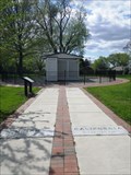
 view gallery view galleryE0.8 km |  Gaithersburg Latitude Observatory Gaithersburg Latitude Observatory
in Astronomical Observatories One of six world-wide latitude observatories built in 1899. The precise nightly star measurements from here were used to prove and monitor the "wobble" of the earth on its north-south axis. Satellites replaced these observatories in 1982. posted by: HaricotVert_52 location: Maryland date approved: 08/13/2016 last visited: 05/25/2015 |
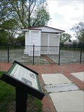 view gallery view galleryE0.8 km | Gaithersburg Latitude Observatory - Gaithersburg, nMD in U.S. National Register of Historic Places This now-unused observatory is one of 6 placed around the world to measure the wobble of the Earth. posted by: Ernmark location: Maryland date approved: 05/04/2015 last visited: 08/12/2016 |
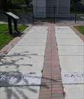 view gallery view galleryE0.8 km |  N 39° 08' N , W 84° 30' - Cincinnati, OH - Gaithersburg, MD N 39° 08' N , W 84° 30' - Cincinnati, OH - Gaithersburg, MD
in Permanent Geographic Coordinates The walkway at a now-unused observatory contains stones with the longitude and elevation of 5 other observatories at the same latitude, which together with this one, were used to measure the wobble of the Earth. posted by: Ernmark location: Maryland date approved: 05/18/2015 last visited: 05/25/2015 |
 view gallery view galleryE0.8 km | N 39° 08' N , W 123° 2' - Ukiah, CA - Gaithersburg, MD in Permanent Geographic Coordinates The walkway at a now-unused observatory contains stones with the longitude and elevation of 5 other observatories at the same latitude, which together with this one, were used to measure the wobble of the Earth. posted by: Ernmark location: Maryland date approved: 05/18/2015 last visited: 10/27/2023 |
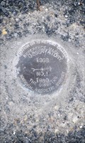 view gallery view galleryE0.8 km | OBSERVATORY RM 1 (JV4124) - Gaithersburg, MD in U.S. Benchmarks A horizontally-adjusted Reference Mark located in a park which contains 5 survey marks and is the site of an observatory which was used to measure the wobble of the Earth on its axis. posted by: Ernmark location: Maryland date approved: 05/11/2015 last visited: 10/26/2023 |
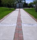 view gallery view galleryE0.8 km | N 39° 08' N , E 141° 12' - Mizusawa, Japan - Gaithersburg, MD in Permanent Geographic Coordinates The walkway at a now-unused observatory contains stones with the longitude and elevation of 5 other observatories at the same latitude, which together with this one, were used to measure the wobble of the Earth. posted by: Ernmark location: Pennsylvania date approved: 05/18/2015 last visited: 10/26/2023 |
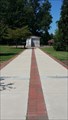
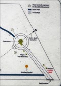 view gallery view galleryE0.8 km |  Observatory Park - Gaithersburg, MD Observatory Park - Gaithersburg, MD
in 'You Are Here' Maps Sign located in a Municipal Park created from the grounds of a former observatory which was used to measure the wobble of the Earth. posted by: Ernmark location: Maryland date approved: 05/13/2015 last visited: 10/26/2023 |
 view gallery view galleryE0.8 km | N 39° 08' N , W 123° 2' - Charjui, Turkestan - Gaithersburg, MD in Permanent Geographic Coordinates The walkway at a now-unused observatory contains stones with the longitude and elevation of 5 other observatories at the same latitude, which together with this one, were used to measure the wobble of the Earth. posted by: Ernmark location: Maryland date approved: 05/18/2015 last visited: 10/26/2023 |
 view gallery view galleryE0.8 km | N 39° 08' N , W 123° 2' - Carloforte, Italy - Gaithersburg, MD in Permanent Geographic Coordinates The walkway at a now-unused observatory contains stones with the longitude and elevation of 5 other observatories at the same latitude, which together with this one, were used to measure the wobble of the Earth. posted by: Ernmark location: Maryland date approved: 05/18/2015 last visited: 10/26/2023 |
 view gallery view galleryE0.8 km |  Observatory Park - Gaithersburg, MD Observatory Park - Gaithersburg, MD
in Municipal Parks and Plazas Municipal Park created from the grounds of a former observatory which was used to measure the wobble of the Earth. posted by: Ernmark location: Maryland date approved: 05/13/2015 last visited: 10/26/2023 |
 view gallery view gallery S1 km S1 km
|  PERFORMANCE Bicycle Shop PERFORMANCE Bicycle Shop
in Bicycle Shops PERFORMANCE Bicycle Shop on Muddy Branch Rd in Gaithersburg is a full-service shop offering bikes, gear, clothing, service and repair. posted by: HaricotVert_52 location: Maryland date approved: 12/29/2008 last visited: 06/04/2010 |
 view gallery view gallery NW1 km NW1 km
|  Flagship Carwash Center - Gaithersburg MD Flagship Carwash Center - Gaithersburg MD
in Coin Operated Self Service Car Washes Even though there is no sign on any main road, this is a very popular local carwash. It always seems to be busy. posted by: HaricotVert_52 location: Maryland date approved: 10/18/2010 last visited: 10/30/2010 |
 view gallery view galleryNW1.1 km |  Bureau Drive McDonald's - Gaithersburg MD Bureau Drive McDonald's - Gaithersburg MD
in McDonald's Restaurants This McDonald's in Gaithersburg is surprisingly busy. It is hidden away behind a shopping plaza and office park and there is no sign for it on any of the nearby roads. posted by: HaricotVert_52 location: Maryland date approved: 01/21/2009 last visited: 06/13/2010 |
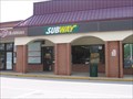 view gallery view galleryNW1.1 km |  Subway - Bureau Drive, Gaithersburg MD Subway - Bureau Drive, Gaithersburg MD
in Subway Restaurants This subway is located in the Diamond Square shopping center along Quince Orchard Road in Gaithersburg MD. posted by: HaricotVert_52 location: Maryland date approved: 06/03/2009 last visited: 08/07/2010 |
 view gallery view gallery N1.1 km N1.1 km
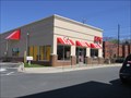
|  KFC - Frederick Avenue, Gaithersburg MD KFC - Frederick Avenue, Gaithersburg MD
in Kentucky Fried Chicken/KFC Restaurants This KFC restaurant in Gaithersburg, MD, has late night hours. posted by: HaricotVert_52 location: Maryland date approved: 04/19/2009 last visited: 06/13/2010 |
 view gallery view galleryN1.1 km |  Montgomery County Fair, Gaithersburg, Maryland Montgomery County Fair, Gaithersburg, Maryland
in Agricultural Fairgrounds The agricultural county fair of Montgomery County. It gives priority to 4-H and FFA.
posted by: Black Dog Trackers location: Maryland date approved: 08/20/2007 last visited: 07/31/2015 |
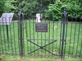 view gallery view gallerySE1.1 km |  DeSellum Family Cemetery - Gaithersburg MD DeSellum Family Cemetery - Gaithersburg MD
in Worldwide Cemeteries Resting place of members of the DeSellum family, some of the earliest settlers of Gaithersburg. posted by: HaricotVert_52 location: Maryland date approved: 05/20/2009 last visited: 06/04/2010 |
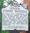 view gallery view galleryE1.1 km |  General Edward Braddock - Gaithersburg, Maryland General Edward Braddock - Gaithersburg, Maryland
in UK Historical Markers Located on the northbound side of route 355 outside of old town Gaithersburg. posted by: flyingmoose location: Maryland date approved: 10/02/2020 last visited: 06/04/2010 |
|