 view gallery view gallery W3.5 km W3.5 km
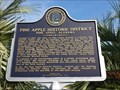
|   Pine Apple, Alabama Historic District Pine Apple, Alabama Historic District
in Alabama Historical Markers Marker describes the history and economics of this small town with an historic district. The town hosts annual "Hunter Appreciation Day" each November and a semi-annual Front Porch Tour. posted by:  hoteltwo hoteltwo location: Alabama date approved: 08/28/2013 last visited: never |
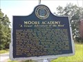 view gallery view galleryW4 km | Moore Academy - Pine Apple, AL in Alabama Historical Markers This former school is one of the 73 properties included in the Pine Apple Historic District that’s listed on the National Register of Historic Places. posted by: hoteltwo location: Alabama date approved: 08/28/2013 last visited: never |
 view gallery view gallery NW4.2 km NW4.2 km
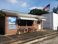
|  Pine Apple, Alabama 36768 Pine Apple, Alabama 36768
in U.S. Post Offices Small town post office located in the Pine Apple Historic District of which several historic buildings are listed in the National Register of Historic Places. posted by: hoteltwo location: Alabama date approved: 08/28/2013 last visited: never |
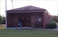
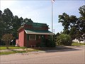 view gallery view galleryNW4.2 km |  Pine Apple, Alabama Pine Apple, Alabama
in City and Town Halls A small town hall for a small town with many historic sites. The name of the town may have come from the areas pine and apple trees. posted by: hoteltwo location: Alabama date approved: 08/29/2013 last visited: never |
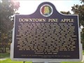 view gallery view galleryNW4.3 km | Downtown Pine Apple, Alabama in Alabama Historical Markers Marker describing the founding and history of Pine Apple. It includes a listing of the early settlers. posted by: hoteltwo location: Alabama date approved: 08/28/2013 last visited: never |
 view gallery view gallery E6.6 km E6.6 km
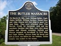
| The Butler Massacre - Forest Home, AL in Alabama Historical Markers Replacement marker describing the history of the naming of Butler County and its namesake. posted by: hoteltwo location: Alabama date approved: 08/28/2013 last visited: 06/15/2019 |
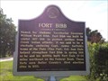 view gallery view galleryE6.6 km | Fort Bibb - Forest Home, AL in Alabama Historical Markers Replacement marker describing the construction and use of Fort Bibb. posted by: hoteltwo location: Alabama date approved: 08/28/2013 last visited: never |
 view gallery view gallery S11.9 km S11.9 km
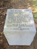
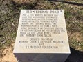
| Old Federal Road - Shackleville, AL in Alabama Historical Markers One of eight stone markers along the Alabama portion of the Federal road established as a postal route by President Jefferson. Located on County Road 38 just west of County Road 7. posted by: hoteltwo location: Alabama date approved: 07/22/2015 last visited: never |
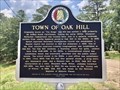 view gallery view galleryNW14.5 km | Town of Oak Hill - Oak Hill, AL in Alabama Historical Markers Marker located at intersection of AL-21 and Dale Drive, provides the settlement history of the town and its churches, schools and commercial beginnings. posted by: hoteltwo location: Alabama date approved: 08/06/2020 last visited: never |
 view gallery view gallery N16.3 km N16.3 km
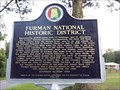
| Furman National Historic District - Furman, AL in Alabama Historical Markers Marker providing the history of the settling of Furman, Alabama, its historic district, and notable citizens. posted by: hoteltwo location: Alabama date approved: 08/28/2013 last visited: never |
 view gallery view galleryN16.7 km | Furman, Alabama 36741 in U.S. Post Offices Furman, also known as Old Snow Hill, is an unincorporated community in Wilcox County, Alabama. posted by: hoteltwo location: Alabama date approved: 08/28/2013 last visited: never |
 view gallery view gallery SW18 km SW18 km
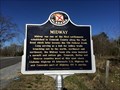
| Midway - Midway, AL in Alabama Historical Markers Marker notes the community started here and is located at the intersection of State, County and U.S. highways. It should not to be confused with the incorporated town of Midway that’s located in Bullock County. posted by: hoteltwo location: Alabama date approved: 03/12/2015 last visited: never |
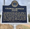 view gallery view galleryE18.3 km | Coleman-Crenshaw House - Greenville, AL in Alabama Historical Markers Marker located near the Mt. Olive Missionary Baptist Church, on Ridge Road at Crenshaw Road, describes one of the counties pioneer families and home. posted by: hoteltwo location: Alabama date approved: 02/17/2019 last visited: never |
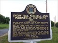 view gallery view galleryNW20 km | Snow Hill Normal and Industrial Institute 1893 - Snow Hill, AL in Alabama Historical Markers History of the founding of the Snow Hill Institute educational institution for African Americans in Alabama’s Black Belt. posted by: hoteltwo location: Alabama date approved: 08/28/2013 last visited: never |
 view gallery view gallerySW22.2 km | Old Federal Road - Midway Alabama in Alabama Historical Markers One of eight stone markers along the Alabama portion of the Federal road established as a postal route by President Jefferson. Located at the intersection of County Road 1 and State Route 83 in Conecuh County. posted by: hoteltwo location: Alabama date approved: 03/24/2015 last visited: never |
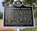 view gallery view galleryE23 km | Ogly-Stroud Massacre - Greenville, AL in Alabama Historical Markers Located northwest of Greenville, at the Old Shiloh Cemetery, along Sherling Lake Road. This marker notes one of the two Indian massacres, that occurred in March, 1818, in Butler County. posted by: hoteltwo location: Alabama date approved: 08/18/2018 last visited: never |
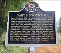 view gallery view galleryE23 km | Gary's Stockade - Greenville, AL in Alabama Historical Markers Due to Indian attacks, a settler built a block house and charged other settlers to use it. An Indian massacre nearby led the government to build a fort, making this one useless. Located northwest of Greenville, at the Old Shiloh Cemetery. posted by: hoteltwo location: Alabama date approved: 08/18/2018 last visited: never |
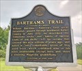 view gallery view galleryE25.6 km | Bartram's Trail - Greenville, AL in Alabama Historical Markers William Bartram traveled the Southeast U.S., including Butler County, from 1773 through 1777. He published observations of plants, animals, geography and people in 1791. Marker located along Sherling Lake Road west of Braggs Road. posted by: hoteltwo location: Alabama date approved: 08/18/2018 last visited: never |
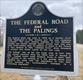 view gallery view galleryE28.2 km | The Federal Road and The Palings - Greenville, AL in Alabama Historical Markers The Federal Road was designated as a postal route through the Creek Indian frontier in lower Alabama. The marker is located at the Fort Dale Cemetery, on Fort Dale Rd, NW of Greenville. posted by: hoteltwo location: Alabama date approved: 02/17/2019 last visited: never |
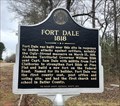 view gallery view galleryE28.2 km | Fort Dale 1818 - Greenville, AL in Alabama Historical Markers Describes the fort built by Captain Dale to protect settlers from Indian attacks during the Creek Wars. The marker is located at the Fort Dale Cemetery, on Fort Dale Rd, NW of Greenville. posted by: hoteltwo location: Alabama date approved: 02/17/2019 last visited: never |
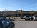 view gallery view galleryE29.6 km |  Cracker Barrel - I-65 Exit 130 - Greenville, Alabama Cracker Barrel - I-65 Exit 130 - Greenville, Alabama
in Cracker Barrel Restaurants This Cracker Barrel is located near I-65, Exit 130 in Greenville, Alabama. This is the Alabama 185 exit. It is on the west side of the interstate. posted by:  xptwo xptwo location: Alabama date approved: 04/02/2012 last visited: 04/30/2021 |
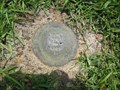 view gallery view galleryE29.8 km |  BU1879 - Alabama Highway Department - Greenville, AL BU1879 - Alabama Highway Department - Greenville, AL
in U.S. Benchmarks This Alabama Highway Department disk is located outside a funeral home in Greenville, Alabama. It was originally monumented in 1980. posted by: xptwo location: Alabama date approved: 08/10/2013 last visited: never |
 view gallery view gallerySW30.1 km | Old Federal Road - Pine Orchard, AL in Alabama Historical Markers One of eight stone markers along the Alabama portion of the Federal road established as a postal route by President Jefferson. Located on County Road 5, south of County Road 42. posted by: hoteltwo location: Alabama date approved: 03/24/2015 last visited: never |
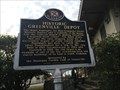 view gallery view galleryE30.6 km | Historic Greenville Depot - Greenville, AL in Alabama Historical Markers This historic train depot, built in 1910, now houses the office of the Greenville Area Chamber of Commerce. posted by: hoteltwo location: Alabama date approved: 12/14/2013 last visited: 06/19/2021 |
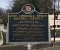 view gallery view galleryE30.6 km | West Commerce Street Historic District - Greenville, AL in Alabama Historical Markers The Greenville West Commerce Street Historic District consists of 8 commercial buildings and the old train depot located next to the Louisville and Nashville Railroad tracks. posted by: hoteltwo location: Alabama date approved: 12/14/2013 last visited: never |
|