 view gallery view gallery NE5.5 km NE5.5 km
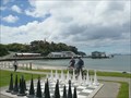
|   Oban Harbor Chess Board - Oban, New Zealand Oban Harbor Chess Board - Oban, New Zealand
in Giant Board Games This Giant Chessboard was found on the beachfront park in Oban, New Zealand posted by:  GT.US GT.US location: South Island, New Zealand date approved: 03/16/2010 last visited: 10/20/2015 |
 view gallery view gallery SE13.8 km SE13.8 km
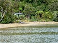
|  Port Adventure Hunters Hut Port Adventure Hunters Hut
in Remote Backcountry Shelters Primarily a Hunters Hut located in Port Adventure on Stewart Island.
Grid reference: Topo50 map sheet CJ10, E1233673, N4778202 posted by: StagsRoar location: South Island, New Zealand date approved: 06/03/2012 last visited: never |
 view gallery view gallery N15.3 km N15.3 km
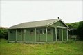
| Bungaree Hut in Remote Backcountry Shelters Bungaree Hut is located on the North East side of Stewart Island posted by: StagsRoar location: South Island, New Zealand date approved: 12/25/2005 last visited: never |
 view gallery view gallery W23.7 km W23.7 km
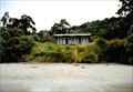
| Masons Bay Hut in Remote Backcountry Shelters Located on Masons Bay, Stewart Island. New Zealand.
Grid reference: Topo50 map sheet CJ08, E1202665, N4789763 posted by: StagsRoar location: South Island, New Zealand date approved: 10/18/2007 last visited: never |
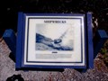 view gallery view galleryNE40.4 km |  England's Glory — Bluff, New Zealand England's Glory — Bluff, New Zealand
in Signs of History The entrance to Bluff Harbour is filled with many stories of shipwrecks. England's Glory is just one of these. posted by: Dunbar Loop location: South Island, New Zealand date approved: 11/22/2009 last visited: never |
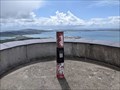 view gallery view galleryNE40.7 km |  The Bluff, 1038 - Bluff Hill, South Island, New Zealand The Bluff, 1038 - Bluff Hill, South Island, New Zealand
in Australia/NZ Benchmarks A deforamation control station located in eth centre of the Bluff Hill lookout posted by:  bucketeer bucketeer location: South Island, New Zealand date approved: 01/28/2023 last visited: never |
 view gallery view galleryNE41.5 km |  46° 36' 54"S, 168° 21' 26"E — Bluff, New Zealand 46° 36' 54"S, 168° 21' 26"E — Bluff, New Zealand
in Permanent Geographic Coordinates This is the southernmost point of State Highway 1, which runs the length of New Zealand. And it is, perhaps, the most photographed point in the country with tourist after tourist lining up to get their picture taken here. posted by: Dunbar Loop location: South Island, New Zealand date approved: 11/09/2009 last visited: 10/20/2015 |
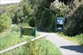 view gallery view galleryNE41.7 km |  Foveaux Walkway and Glory Track — Bluff, New Zealand Foveaux Walkway and Glory Track — Bluff, New Zealand
in Hiking and walking trailheads The starting point of two great walking trails. The Foveaux Walkway runs around the base of Bluff Hill and takes about two to three hours. The Glory walk goes over top the hill and you can loop back on Foveaux Walkway to the start for an hour's walk. posted by: Dunbar Loop location: South Island, New Zealand date approved: 11/10/2009 last visited: 12/13/2014 |
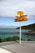
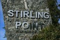
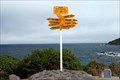 view gallery view galleryNE41.7 km |  Stirling Point Stirling Point
in Direction and Distance Arrows Located at the Southern end of the South Island behind the township & Port of Bluff posted by: StagsRoar location: South Island, New Zealand date approved: 04/30/2006 last visited: 09/08/2006 |
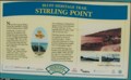 view gallery view galleryNE41.7 km | Sterling Point - Bluff, New Zealand in Signs of History Marker giving history of the Sterling Point area of Bluff, New Zealand. posted by:  BruceS BruceS location: South Island, New Zealand date approved: 01/24/2013 last visited: 12/13/2014 |
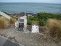 view gallery view galleryNE41.7 km |  William Stirling - Bluff, New Zealand William Stirling - Bluff, New Zealand
in Citizen Memorials Memorial placed on Stirling Point to honor individual who established a whaling station and was early settler in the area. posted by: BruceS location: South Island, New Zealand date approved: 01/24/2013 last visited: 03/13/2013 |
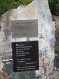 view gallery view galleryNE41.7 km |  Bible Psalm 93-4 - William Stirling Memorial - Bluff, New Zealand Bible Psalm 93-4 - William Stirling Memorial - Bluff, New Zealand
in Etched in Stone Memorial placed on Stirling Point to honor individual who established a whaling station and was early settler in the area and includes a quote from the Bible. posted by: BruceS location: South Island, New Zealand date approved: 01/24/2013 last visited: 03/13/2013 |
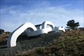 view gallery view galleryNE41.7 km |  The Chain Link The Chain Link
in Abstract Public Sculptures An anchor chain linking the South Island with Stewart Island. posted by: Dunbar Loop location: South Island, New Zealand date approved: 08/16/2009 last visited: 03/13/2013 |
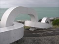 view gallery view galleryNE41.7 km |  Giant anchor chain. Bluff. New Zealand. Giant anchor chain. Bluff. New Zealand.
in Realistic Object Sculptures A giant steel anchor chain lying on the Bluff coast links the South Island to Stewart Island. posted by: Punga and Paua location: South Island, New Zealand date approved: 07/22/2015 last visited: 07/22/2015 |
 view gallery view galleryNE41.7 km | 46° 36' 53" S, 168° 21' 21" E — Bluff, New Zealand in Permanent Geographic Coordinates The Stirling Point entrance sign. posted by: Dunbar Loop location: South Island, New Zealand date approved: 08/17/2009 last visited: 03/13/2013 |
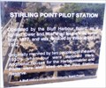 view gallery view galleryNE41.8 km | Stirling Point Pilot Station in Signs of History A brief discussion about the previous and current Stirling Point Pilot Houses. posted by: Dunbar Loop location: South Island, New Zealand date approved: 08/16/2009 last visited: 03/13/2013 |
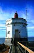 view gallery view galleryNE41.8 km |  Stirling Point Pilot Station Stirling Point Pilot Station
in Octagon Buildings Built in 1912 this octagon building housed pilots to guide ships into Bluff harbour. posted by: Dunbar Loop location: South Island, New Zealand date approved: 09/02/2009 last visited: 09/08/2006 |
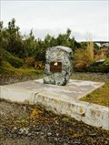
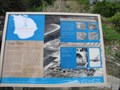 view gallery view galleryNE41.8 km | Tiwai Point - Bluff, New Zealand in Signs of History Historical marker giving history of a point opposite Stirling Point now occupied by an aluminum smelter. Marker located near the Stirling Point Signal Station. posted by: BruceS location: South Island, New Zealand date approved: 01/27/2013 last visited: 02/08/2015 |
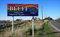 view gallery view galleryNE42.2 km |  Bluff — Where the highway begins… Bluff — Where the highway begins…
in Welcome Signs Bluff is the southern terminus of State Highway 1 which runs the length of New Zealand posted by: Dunbar Loop location: South Island, New Zealand date approved: 08/23/2009 last visited: 12/13/2014 |
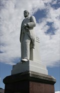 view gallery view galleryNE42.2 km |  Sir Joseph Ward — Bluff, New Zealand Sir Joseph Ward — Bluff, New Zealand
in Statues of Historic Figures Sir Joseph Ward was the 17th Prime Minister of New Zealand serving two terms at the turn of the 20th century. He arrived in Bluff as a boy and worked hard first as a local businessman and then a politician for Bluff and New Zealand. posted by: Dunbar Loop location: South Island, New Zealand date approved: 11/11/2009 last visited: 12/13/2014 |
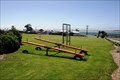 view gallery view galleryNE42.3 km |  Argyle Park Playground — Bluff, New Zealand Argyle Park Playground — Bluff, New Zealand
in Public Playgrounds A simple playground that is by the motor camp in Bluff. posted by: Dunbar Loop location: South Island, New Zealand date approved: 11/10/2009 last visited: never |
 view gallery view galleryNE42.3 km |  War Memorial — Bluff, New Zealand War Memorial — Bluff, New Zealand
in Non-Specific Veteran Memorials A memorial dedicated to all service men and women that served for every country posted by: Dunbar Loop location: South Island, New Zealand date approved: 10/02/2009 last visited: 12/13/2014 |
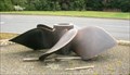 view gallery view galleryNE42.3 km |  A ship's screw — Bluff, New Zealand A ship's screw — Bluff, New Zealand
in Ship Screws and Aircraft Props A ship's screw outside the Bluff Maritime Museum. There is no vessel associated with this screw. posted by: Dunbar Loop location: South Island, New Zealand date approved: 10/04/2009 last visited: 12/13/2014 |
 view gallery view galleryNE42.3 km |  Bluff Maritime Museum - Bluff, New Zealand Bluff Maritime Museum - Bluff, New Zealand
in Maritime Museums Focusing on almost 200 years of history of Bluff harbour posted by: Dunbar Loop location: South Island, New Zealand date approved: 10/02/2009 last visited: 03/13/2013 |
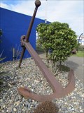 view gallery view galleryNE42.3 km |  Bluff Maritime Museum Anchor - Bluff, New Zealand Bluff Maritime Museum Anchor - Bluff, New Zealand
in Anchors Anchor on display outside the Bluff Maritime Museum in Bluff, New Zealand. posted by: BruceS location: South Island, New Zealand date approved: 01/23/2013 last visited: 12/13/2014 |
|