 view gallery view gallery NW99.6 km NW99.6 km
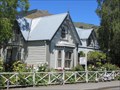
|   Cheviot Hills Homestead - Cheviot, Canterbury, New Zealand Cheviot Hills Homestead - Cheviot, Canterbury, New Zealand
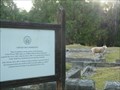
in Preserved Architectural Remnants and Ruins Cheviot Hills Homestead (locally known as Mansion House) burnt down in 1936, leaving only the sandstone foundation that you can see today. posted by:  Trail Blaisers Trail Blaisers location: South Island, New Zealand date approved: 01/18/2014 last visited: never |
 view gallery view galleryNW100.1 km |  Cheviot Hills Reserve - Cheviot, Canterbury, New Zealand Cheviot Hills Reserve - Cheviot, Canterbury, New Zealand
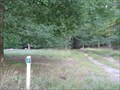
in Municipal Parks and Plazas Cheviot Hills Reserve is managed by Hurunui District Council and is a fine place to walk and geocache (and now waymark!). There are some very large trees. Sheep graze throughout the woodlands. posted by: Trail Blaisers location: South Island, New Zealand date approved: 01/02/2014 last visited: never |
 view gallery view galleryNW100.4 km |  Knox Presbyterian Church - Cheviot, New Zealand Knox Presbyterian Church - Cheviot, New Zealand
in Cobblestone Buildings This stone church is built with stones gathered from near the Hurunui River. It was opened in September 1953. posted by: waiiti20 location: South Island, New Zealand date approved: 02/22/2016 last visited: 02/21/2016 |
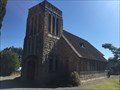
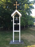 view gallery view galleryNW101.5 km |  St Anthonys Catholic Church - Cheviot, New Zealand St Anthonys Catholic Church - Cheviot, New Zealand
in Bell Towers The picturesque St Anthony's Catholic Church, located on a scenic just on the edge of Cheviot township posted by: waiiti20 location: South Island, New Zealand date approved: 02/19/2016 last visited: 02/19/2016 |
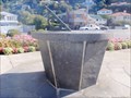
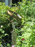 view gallery view gallery SW102.5 km SW102.5 km
|  Armillary Sundial, Akaroa, New Zealand Armillary Sundial, Akaroa, New Zealand
in Sundials On Rue Balgueire in Akaroa is an armillary sundial in an exuberant front garden. This is a standard, garden variety armillary, but not properly oriented to show correct solar time. posted by:  arby101ca arby101ca location: South Island, New Zealand date approved: 12/17/2012 last visited: never |
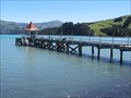 view gallery view gallerySW102.8 km |  Daly's Pier, Akaroa, New Zealand Daly's Pier, Akaroa, New Zealand
in Piers Daly's Wharf is the original pier for the town of Akaroa, dating back almost 150 years. The pier is open to the public for fishing, swimming or boarding the Fox II, the oldest wooden gaff rigged sailing ketch in New Zealand. posted by: arby101ca location: South Island, New Zealand date approved: 01/11/2013 last visited: 01/02/2011 |
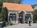 view gallery view gallerySW103.2 km |  Coronation Library, Akaroa New Zealand Coronation Library, Akaroa New Zealand
in New Zealand Historic Places The Coronation Library is an interesting example of the historical places in the town of Akaroa. posted by: arby101ca location: South Island, New Zealand date approved: 01/12/2013 last visited: never |
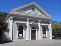 view gallery view gallerySW103.2 km |  The Gaiety, Akaroa, New Zealand The Gaiety, Akaroa, New Zealand
in Concert Halls The Gaiety was originally built as an Oddfellows Hall opening on the 3 April 1879. It has served as the community entertainment hall since for live theatrical performances, movies and musical concerts. Now the finction as a concert hall dominates. posted by: arby101ca location: South Island, New Zealand date approved: 01/07/2013 last visited: never |
 view gallery view gallerySW103.2 km |  La Belle Vila B&B, Akaroa, New Zealand La Belle Vila B&B, Akaroa, New Zealand
in Bed and Breakfast La Belle Vista is a B&B in Akaroa that provides excellent accomodation with a historical ambiance. posted by: arby101ca location: South Island, New Zealand date approved: 01/07/2013 last visited: never |
 view gallery view gallerySW103.2 km |  Lucky Seven, Akaroa, New Zealand Lucky Seven, Akaroa, New Zealand
in Lucky 7 Akaroa is an interesting historical harbour town, on the Banks Peninsula, a two hour drive from Christchurch. The town was founded by French settlers in 1840 and maintains a French flavour, with 63 registered historic places. Tally = 7 department posted by: arby101ca location: South Island, New Zealand date approved: 01/22/2013 last visited: never |
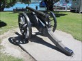 view gallery view gallerySW103.3 km |  Bronze Field Artillery, Akaroa, NZ Bronze Field Artillery, Akaroa, NZ
in Static Artillery Displays At the harbour of Akaroa on the Banks Peninsula is a 4" bronze field artillery piece, perhaps a reminder of the territorial disputes settling New Zealand in the 19th century. posted by: arby101ca location: South Island, New Zealand date approved: 12/09/2012 last visited: never |
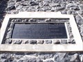
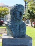 view gallery view gallerySW103.3 km |  Commander Worsley - Akaroa, New Zealand Commander Worsley - Akaroa, New Zealand
in Statues of Historic Figures A bronze bust of Commander Frank Arthur Worsley, DSO and Bar, OBE, RNR, looks out at the sea in a small park near Akoroa's main wharf. He is dressed in a thick woollen hood suitable for Antarctic exploration. The plaque quoted below explains why. posted by: arby101ca location: South Island, New Zealand date approved: 01/08/2013 last visited: never |
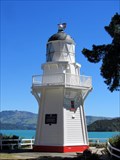
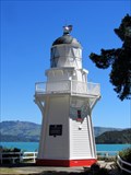 view gallery view gallerySW103.8 km |  Akaroa Head Lighthouse, Akaroa New Zealand Akaroa Head Lighthouse, Akaroa New Zealand
in Coastal Lighthouses The historic Akaroa Head lighthouse built in 1880 was moved in 1980 to current location close to the town of Akaroa. It was replaced with an automated light and moved to preserve the historic lighthouse. posted by: arby101ca location: South Island, New Zealand date approved: 12/18/2012 last visited: never |
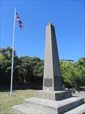 view gallery view gallerySW104.6 km |  Britomart Monument, Akaroa, New Zealand Britomart Monument, Akaroa, New Zealand
in Obelisks The Britomart Monument consists of a 15 foot obelisk engraved to tell the history and a flagpole flying the Union Jack. The monument was erected in 1898 to celebrate Queen Victoria’s Diamond Jubilee. posted by: arby101ca location: South Island, New Zealand date approved: 12/17/2012 last visited: never |
 view gallery view gallery W111.8 km W111.8 km
|  Bernard Hansen — Christchurch, New Zealand Bernard Hansen — Christchurch, New Zealand
in Citizen Memorials Bernard Hansen, the Guardian of Sumner. posted by: Dunbar Loop location: South Island, New Zealand date approved: 04/09/2010 last visited: never |
 view gallery view galleryW112 km | Edmund Green — Christchurch, New Zealand in Citizen Memorials At the south end of the Sumner Beach is this magnificent stone clock tower erected in the memory of Edmund Green who arrived in New Zealand in 1859 with the purpose of developing the first telegraph system in the country. posted by: Dunbar Loop location: South Island, New Zealand date approved: 04/16/2010 last visited: never |
 view gallery view galleryW112 km |  FIRST — Telegraph System in New Zealand — Christchurch, New Zealand FIRST — Telegraph System in New Zealand — Christchurch, New Zealand
in First of its Kind Edmund Green arrived in New Zealand in 1859 to build the nation's first telegraph system. In 1934 his built this clock tower in his honour and "to perpetuate the name of his father". posted by: Dunbar Loop location: South Island, New Zealand date approved: 04/16/2010 last visited: never |
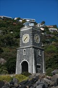 view gallery view galleryW112 km |  Scarborough Clock Tower — Christchurch, New Zealand Scarborough Clock Tower — Christchurch, New Zealand
in Town Clocks Erected in 1934 to the memory of Edmund Green by his son Richard Edward Green, this clock stands over the Sumner Beach and recalls Edmund Green came to New Zealand to establish the first telegraph system. posted by: Dunbar Loop location: South Island, New Zealand date approved: 04/16/2010 last visited: 03/23/2021 |
 view gallery view galleryW112.7 km | Joseph Day — Christchurch, New Zealand in Citizen Memorials A pilot based in Sumner saved some 26 people during his career. posted by: Dunbar Loop location: South Island, New Zealand date approved: 04/09/2010 last visited: 11/10/2009 |
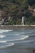
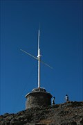
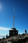 view gallery view galleryW112.7 km |  Joseph Day Memorial Flag Pole — Christchurch, New Zealand Joseph Day Memorial Flag Pole — Christchurch, New Zealand
in Nautical Flag Poles Atop Cave Rock the Joseph Day Memorial recognises a pilot of Sumner, who, in a career spanning from 1869 until 1913, saved 26 people. posted by: Dunbar Loop location: South Island, New Zealand date approved: 04/09/2010 last visited: 03/24/2024 |
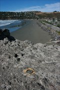 view gallery view galleryW112.7 km |  CAVE ROCK — Christchurch, New Zealand CAVE ROCK — Christchurch, New Zealand
in Australia/NZ Benchmarks Located at the top of Cave Rock this benchmark overlooks Sumner Beach. posted by: Dunbar Loop location: South Island, New Zealand date approved: 04/09/2010 last visited: 03/24/2024 |
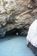 view gallery view galleryW112.7 km | ") Cave Rock — Christchurch, New Zealand Cave Rock — Christchurch, New Zealand
in Cave Entrances (Natural) Cave Rock is a large rock on the Sumner foreshore feature a large sea cave where people can walk through without bending. posted by: Dunbar Loop location: South Island, New Zealand date approved: 04/17/2010 last visited: 03/24/2024 |
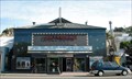 view gallery view galleryW112.8 km |  Hollywood Cinema — Christchurch, New Zealand Hollywood Cinema — Christchurch, New Zealand
in Vintage Movie Theaters The Hollywood Cinema feature three screens and is very popular with the residents of Sumner. Many of the restaurants and cafes along Marriner Street offer dinner-and-movie meals timed for your flick. posted by: Dunbar Loop location: South Island, New Zealand date approved: 04/13/2010 last visited: never |
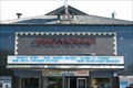 view gallery view galleryW112.8 km |  Hollywood Cinema — Christchurch, New Zealand Hollywood Cinema — Christchurch, New Zealand
in Neon Signs The Hollywood 3 Cinema in the Sumner suburb of Christchurch features a simple neon sign. posted by: Dunbar Loop location: South Island, New Zealand date approved: 04/13/2010 last visited: never |
 view gallery view galleryW112.8 km | Sumner Sundial — Christchurch, New Zealand in Sundials A simple sundial in a roadside reserve in Sumner. posted by: Dunbar Loop location: South Island, New Zealand date approved: 04/13/2010 last visited: never |
|