 view gallery view gallery W23.2 km W23.2 km
|   Apsley Falls, NSW, Australia Apsley Falls, NSW, Australia
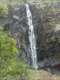
in Waterfalls Apsley Falls are a two-tiered cascade, that drops a total of 123 m, with the longest drop being 65 m. Discovered in 1818 by John Oxley, who named the Apsley River, which descends through a sheer sided gorge. posted by:  Grahame Cookie Grahame Cookie location: New South Wales, Australia date approved: 08/14/2015 last visited: 07/24/2022 |
 view gallery view galleryW24.3 km |  Apsley Falls, NSW, Australia Apsley Falls, NSW, Australia
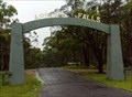
in Freestanding Arches This freestanding arch off the Oxley Highway is for the entry road to Apsley Falls, a pair of waterfalls (65 m and 58 m high), about a kilometre away, in the Oxley Wild Rivers National Park. posted by: Grahame Cookie location: New South Wales, Australia date approved: 07/16/2015 last visited: 05/03/2023 |
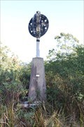
 view gallery view gallery SE25.1 km SE25.1 km
|  Melville trig, Yarrowitch, NSW Melville trig, Yarrowitch, NSW
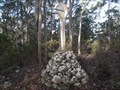
in Australian Trig Points About a kilometre west of Racecourse Trail (or Youdales Trail), in the Werrikimbe NP and Yarrowitch regions is this rock cairn trig.
Official code: TS3054. Elevation: +/- 1,050 metres. posted by: Grahame Cookie location: New South Wales, Australia date approved: 11/24/2016 last visited: never |
 view gallery view gallerySE26.2 km |  Kunderang Wilderness UR Here, Werrikimbe NP, NSW, Australia Kunderang Wilderness UR Here, Werrikimbe NP, NSW, Australia
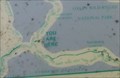
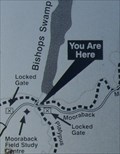
in 'You Are Here' Maps At the junction of Racecourse Trail, and Youdales West Trail, is a dilapidated map from the National Parks and Wildlife Service, showing where you are in the Kunderang Wilderness - Werrikimbe National Park. posted by: Grahame Cookie location: New South Wales, Australia date approved: 10/24/2016 last visited: never |
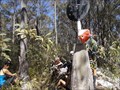 view gallery view gallerySE26.4 km | Drain trig, Kunderang Wilderness Area, Werrikimbe, NSW in Australian Trig Points Situated not far off a dirt track leading into the Kunderang Wilderness Area, on the northern part of the Werrikimbe National Park is this concrete pedestal trig, with intact post, vanes, and name plate. Official Code: TS6304 posted by: Grahame Cookie location: New South Wales, Australia date approved: 11/16/2015 last visited: never |
 view gallery view gallerySE27.7 km | URHere, Platypus Pools Walk, Werrikimbe NP, NSW, Australia in 'You Are Here' Maps Just over the rise of the Mooraback Camping area, in the Werrikimbe National Park (below the Service Hut), is the start of the Platypus Pools Walk. Keep your eyes open for kangaroos as well. posted by: Grahame Cookie location: New South Wales, Australia date approved: 03/21/2016 last visited: never |
 view gallery view gallery S28.3 km S28.3 km
|  Yarrowitch Church, NSW, Australia Yarrowitch Church, NSW, Australia
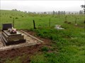
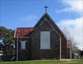
in Churchyard Cemeteries The small country Church in the locality of Yarrowitch has a few headstones out the back. posted by: Grahame Cookie location: New South Wales, Australia date approved: 11/14/2016 last visited: never |
 view gallery view galleryS28.3 km |  Yarrowitch, NSW, Australia Yarrowitch, NSW, Australia
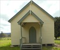
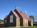
in Country Churches This quaint church is at the locality of Yarrowitch, just off of the Oxley Highway, about 48 km east of Walcha. posted by: Grahame Cookie location: New South Wales, Australia date approved: 11/09/2016 last visited: never |
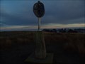
 view gallery view gallery N35.1 km N35.1 km
| Raspberry Trig - Styx River State Forest NSW in Australian Trig Points An intact Trig point on a 4wd track in the Styx River State Forest. Official COde: TS6380. posted by:  John1041 John1041 location: New South Wales, Australia date approved: 08/19/2018 last visited: 12/16/2018 |
 view gallery view galleryW35.2 km |  Oxley Rural Fire Brigade Oxley Rural Fire Brigade
in Firehouses This Rural Fire Brigade is another volunteer brigade, south of Walcha, on the Brackendale road. posted by: Grahame Cookie location: New South Wales, Australia date approved: 12/18/2016 last visited: never |
 view gallery view galleryW35.6 km | Walcha GS, Walcha, NSW in Australian Trig Points 'Right' beside Brackendale Road, actually a few hundred metres into the property, is this beautiful, white-painted, concrete pedestal trig, with intact post, vanes and nameplate. Official Code: TS6273 posted by: Grahame Cookie location: New South Wales, Australia date approved: 01/20/2016 last visited: never |
 view gallery view gallery SW35.7 km SW35.7 km
| Porters, Mummel Gulf NP, NSW in Australian Trig Points Previously called Great Dividing Range Area on GCA, actually has nameplate of Porters. Behind the enclosed radio towers. Official Code: TS5651 posted by: Grahame Cookie location: New South Wales, Australia date approved: 11/29/2014 last visited: never |
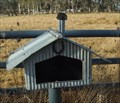 view gallery view gallerySW38.6 km |  Homestead, Brackendale, NSW, Australia Homestead, Brackendale, NSW, Australia
in Themed Homemade Mailboxes South of Walcha, on Brackendale Rd is this 'corrugated iron' letterbox, styled to look like a homestead. posted by: Grahame Cookie location: New South Wales, Australia date approved: 10/29/2015 last visited: never |
 view gallery view gallerySW38.6 km | Ben Nevis, Brackendale, NSW, Australia in Themed Homemade Mailboxes South of Walcha, almost opposite Lakes Rd on Brackendale Road is this black, beef Angus cattle shaped letter box for the Ben Nevis Angus cattle property. posted by: Grahame Cookie location: New South Wales, Australia date approved: 10/29/2015 last visited: never |
 view gallery view galleryW38.8 km |  Walcha LPO, NSW, 2354 Walcha LPO, NSW, 2354
in Australia Post Offices The LPO in the "Open Air Sculpture Gallery" town posted by: blingg location: New South Wales, Australia date approved: 07/30/2022 last visited: 08/13/2023 |
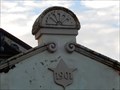 view gallery view galleryW38.8 km |  1901 - Library - Walcha, NSW, Australia 1901 - Library - Walcha, NSW, Australia
in Dated Buildings and Cornerstones This former Council Chambers is now the local Walcha Library and History Centre, built in 1901. posted by: Grahame Cookie location: New South Wales, Australia date approved: 04/27/2024 last visited: never |
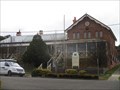 view gallery view galleryW38.8 km |  Walcha Courthouse, Apsley St, Walcha, NSW, Australia Walcha Courthouse, Apsley St, Walcha, NSW, Australia
in Australian Heritage Sites Walcha courthouse posted by: blingg location: New South Wales, Australia date approved: 07/21/2022 last visited: 08/13/2023 |
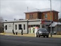
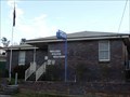 view gallery view galleryW38.8 km |  Police Station - Walcha, NSW, Australia Police Station - Walcha, NSW, Australia
in Police Stations This is the Police Station for the country town of Walcha. posted by: Grahame Cookie location: New South Wales, Australia date approved: 04/15/2024 last visited: never |
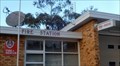 view gallery view galleryW38.8 km | Fire Station | Fire + Rescue in Firehouses This brick building is the Firehouse for the Fire & Rescue NSW retained fire fighters of Walcha. posted by: Grahame Cookie location: New South Wales, Australia date approved: 04/28/2024 last visited: never |
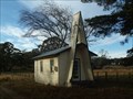 view gallery view gallerySW38.9 km | Brackendale, NSW, Australia in Country Churches South of Walcha, on Brackendale Road is this lonely church. posted by: Grahame Cookie location: New South Wales, Australia date approved: 09/25/2015 last visited: never |
 view gallery view galleryW38.9 km | Langford, Nowendoc Rd, Walcha, NSW, Australia in Australian Heritage Sites Langford is historically significant, as it was on the flat near the Apsley River that John Oxley set up his camp on 8 September 1818. posted by: blingg location: New South Wales, Australia date approved: 07/27/2022 last visited: 08/13/2023 |
 view gallery view galleryW38.9 km |  Walcha Prime Meats, Walcha, NSW, Australia Walcha Prime Meats, Walcha, NSW, Australia
in Time and Temperature Signs The Old Style butcher has 'modernised' and included a Time, and Temperature LED display on posted by: Grahame Cookie location: New South Wales, Australia date approved: 07/23/2017 last visited: 07/23/2022 |
 view gallery view galleryW39.1 km | St Andrews Anglican Church (former), Walcha, NSW, Australia in This Old Church The oldest church in Walcha posted by: blingg location: New South Wales, Australia date approved: 07/23/2022 last visited: 08/12/2023 |
 view gallery view galleryW39.1 km | St Andrews Anglican Church (former), South St, Walcha, NSW, Australia in Australian Heritage Sites The oldest church in Walcha posted by: blingg location: New South Wales, Australia date approved: 07/23/2022 last visited: 08/13/2023 |
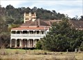
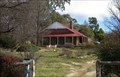 view gallery view galleryW39.4 km | St Andrews Rectory (former) including Garden and Trees, Fitzroy St, Walcha, NSW, Australia in Australian Heritage Sites The former Anglican rectory posted by: blingg location: New South Wales, Australia date approved: 07/23/2022 last visited: 08/13/2023 |
|