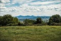
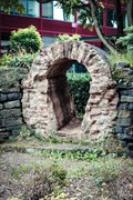
 view gallery view gallery W0.5 km W0.5 km
|   Aussicht vom Blutpfad, Bornheim, NRW, Germany Aussicht vom Blutpfad, Bornheim, NRW, Germany
in Scenic Overlooks Scenic view from "Blutpfad" near Bornheim. posted by:  argus1972 argus1972 location: Nordrhein-Westfalen, Germany date approved: 08/01/2017 last visited: 04/15/2019 |
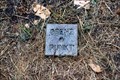 view gallery view gallery S0.8 km S0.8 km
|  Grenzpunkt Heimatblick - Bonn/Bornheim, NRW, Germany Grenzpunkt Heimatblick - Bonn/Bornheim, NRW, Germany
in European Historic Survey Stones, Monuments and Benchmarks Geodetic survey stone below the "Heimatblick". posted by: Maisi2 location: Nordrhein-Westfalen, Germany date approved: 08/10/2016 last visited: 08/27/2019 |
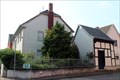
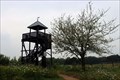 view gallery view galleryW0.8 km |  Aussichtsturm Bornheim-Botzdorf - Bornheim, NRW, Germany Aussichtsturm Bornheim-Botzdorf - Bornheim, NRW, Germany
in Look-Out Towers The look-out tower offers panoramic views of the Rhine Valley from Cologne to the Siebengebirge and the Ville. posted by: Maisi2 location: Nordrhein-Westfalen, Germany date approved: 07/24/2016 last visited: 03/02/2024 |
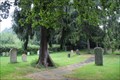 view gallery view galleryS0.8 km |  Jüdischer Friedhof Alfter - Bonn, NRW, Germany Jüdischer Friedhof Alfter - Bonn, NRW, Germany
in Worldwide Cemeteries Little inactive Jewish Cemetery in Alfter (district of Bonn). posted by: Maisi2 location: Nordrhein-Westfalen, Germany date approved: 07/24/2016 last visited: 08/27/2019 |
 view gallery view gallery N1 km N1 km
|  Altrömische Wasserleitung vor dem Rathaus - Bornheim, NRW, Germany Altrömische Wasserleitung vor dem Rathaus - Bornheim, NRW, Germany
in Ancient Roman Civilization A section of the Roman "Eifelkanal" was put up in front of the town hall of Bornheim. posted by: argus1972 location: Nordrhein-Westfalen, Germany date approved: 07/31/2017 last visited: 12/16/2023 |
 view gallery view galleryN1.3 km |  Schillerstraße - GERMAN CLASSIC EDITION - Bornheim, NRW, Germany Schillerstraße - GERMAN CLASSIC EDITION - Bornheim, NRW, Germany
in Monopoly in the Real World Schillertraße in Bornheim / Rhein-Sieg-Kreis / NRW / Germany. posted by: Maisi2 location: Nordrhein-Westfalen, Germany date approved: 07/24/2016 last visited: 12/16/2023 |
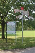
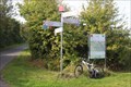
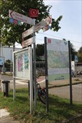 view gallery view gallery SE1.4 km SE1.4 km
|  4 - Alfter - DE - RadRegionRheinland 4 - Alfter - DE - RadRegionRheinland
in Cycling Routes Knotenpunkt 4 liegt in Alfter an der Kreuzung Bahnhofstraße / Im Benden. posted by: Narayan, location: Nordrhein-Westfalen, Germany date approved: 11/21/2023 last visited: never |
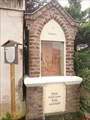 view gallery view gallery NW1.9 km NW1.9 km
|  Stationenweg Bornheim, NRW, Germany Stationenweg Bornheim, NRW, Germany
in Outdoor Stations of the Cross Kreuzweg über 14 Stationen von Bornheim hinauf nach Brenig.---Outdoor Stations of the Cross with 14 stations from Bornheim up to Brenig. posted by: Maisi2 location: Nordrhein-Westfalen, Germany date approved: 07/23/2017 last visited: 09/18/2018 |
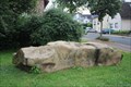 view gallery view galleryNW1.9 km |  Driftblock an der Klippe - Brenig (Bornheim), NRW, Germany Driftblock an der Klippe - Brenig (Bornheim), NRW, Germany
in Rock and Mineral Displays Drift block "An der Klippe" in Brenig (Bornheim), NRW, Germany. posted by: Maisi2 location: Nordrhein-Westfalen, Germany date approved: 07/30/2016 last visited: 09/18/2018 |
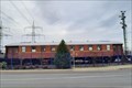 view gallery view gallery E1.9 km E1.9 km
|  DSG Speisewagen 555 - Bornheim, NRW, Germany DSG Speisewagen 555 - Bornheim, NRW, Germany
in Static Train Cars DSG Speisewagen 555, Baureihe WR4üe 36/49 in Bornheim. posted by: FamilieFrohne location: Nordrhein-Westfalen, Germany date approved: 02/01/2021 last visited: never |
 view gallery view galleryE2.1 km |  Statue of Liberty - Bornheim, NRW, Germany Statue of Liberty - Bornheim, NRW, Germany
in Statues of Liberty DE: Diese Freiheitsstatue befindet sich vor dem amerikanischen Restaurant "Miss PeppeR" in Bornheim-Alfter.
EN: This statue of liberty is in front of the american restaurant "Miss PeppeR" in the Alfter district of Bornheim. posted by: FamilieFrohne location: Nordrhein-Westfalen, Germany date approved: 01/03/2021 last visited: never |
 view gallery view galleryE2.1 km |  Miss PeppeR Bornheim - Bornheim, NRW, Germany Miss PeppeR Bornheim - Bornheim, NRW, Germany
in Burger Shops - Regional Chains DE: Filiale der amerikanischen Restaurantkette "Miss PeppeR" in Bornheim-Alfter.
EN: Branch of the American style restaurant chain "Miss PeppeR" in Bornheim-Alfter. posted by: FamilieFrohne location: Nordrhein-Westfalen, Germany date approved: 01/09/2021 last visited: never |
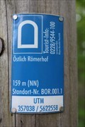 view gallery view gallery SW2.3 km SW2.3 km
|  Östlich Römerhof - Bornheim, Germany - 159 m Östlich Römerhof - Bornheim, Germany - 159 m
in Elevation Signs DE: Höhenmeterschild am Wanderweg Römerweg.
EN: Elevation sign at the hiking trail Römerweg. posted by: Narayan, location: Nordrhein-Westfalen, Germany date approved: 07/23/2018 last visited: 09/20/2019 |
 view gallery view gallery NE2.4 km NE2.4 km
|  Burger King - Bornheim - Bornheim, NRW, Germany Burger King - Bornheim - Bornheim, NRW, Germany
in Burger King Restaurants DE: Burger King Restaurant in der Nähe der Autobahn 555 Abfahrt Bornheim.
EN: Burger King restaurant near the Autobahn 555, exit Bornheim. posted by: FamilieFrohne location: Nordrhein-Westfalen, Germany date approved: 01/10/2021 last visited: never |
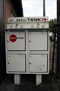 view gallery view galleryW2.4 km |  Akku-Tanke - Brenig (Bornheim), Germany Akku-Tanke - Brenig (Bornheim), Germany
in Electric Bike Charging Stations Charging station for E-Bikes at the Water Tower in Brenig (Bornheim), NRW, Germany. posted by: Maisi2 location: Nordrhein-Westfalen, Germany date approved: 07/24/2016 last visited: 07/24/2019 |
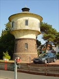
 view gallery view galleryW2.4 km |  Wasserturm Brenig Wasserturm Brenig
in Water Towers Der Wasserturm in Brenig posted by: roli_29 location: Nordrhein-Westfalen, Germany date approved: 05/16/2008 last visited: 07/24/2019 |
 view gallery view gallerySW2.7 km |  Golfanlage Römerhof - Bornheim, Germany Golfanlage Römerhof - Bornheim, Germany
in Public and Private Golf Courses DE: Golfplatz zwischen Bornheim und Heimerzheim.
EN: Golf course between Bornheim and Heimerzheim. posted by: Narayan, location: Nordrhein-Westfalen, Germany date approved: 05/02/2018 last visited: 09/20/2019 |
 view gallery view galleryE2.7 km | 70 - Bonn-Tannenbusch - DE - RadRegionRheinland in Cycling Routes Knotenpunkt 70 liegt im Grüngürtel bei Bonn-Tannenbusch am Buschdorfer Weg. posted by: Narayan, location: Nordrhein-Westfalen, Germany date approved: 11/21/2023 last visited: never |
 view gallery view gallerySE2.7 km | 71 - Alfter - DE - RadRegionRheinland in Cycling Routes Knotenpunkt 71 liegt zwischen Bonn und Alfter an der Landstraße K12 und dem Weg Am Bähnchen. posted by: Narayan, location: Nordrhein-Westfalen, Germany date approved: 11/21/2023 last visited: never |
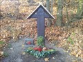 view gallery view galleryN3.1 km |  Ahrweiler (s) Kreuz Ahrweiler (s) Kreuz
in Christian Crosses Ein Wegekreuz unweit der L281. posted by: maacs location: Nordrhein-Westfalen, Germany date approved: 11/22/2011 last visited: 04/18/2018 |
 view gallery view galleryS3.2 km | Alfter-Gilsdorf Water tower in Water Towers The old water tower of Alfter Gilsdorf is monument of the art of building at former times posted by: metasokol location: Nordrhein-Westfalen, Germany date approved: 09/23/2005 last visited: 08/25/2020 |
 view gallery view galleryS3.2 km |  Turmstation Alfter-Gielsdorf - Alfter, Germany Turmstation Alfter-Gielsdorf - Alfter, Germany
in Historic Transformer Sub-Stations Buildings DE: Ehemalige Turmstation am westlichen Rand von Alfter-Gielsdorf.
EN: Former sub-station building on the western edge of Alfter-Gielsdorf. posted by: Narayan, location: Nordrhein-Westfalen, Germany date approved: 07/18/2018 last visited: 08/25/2020 |
 view gallery view gallerySW3.4 km | Historische Grenzsteine am Kamelleboom - Kottenforst, Germany in European Historic Survey Stones, Monuments and Benchmarks DE: Sammlung von historischen Grenzsteinen im Kottenforst.
EN: Collection of historical boundary stones in the forest Kottenforst. posted by: Narayan, location: Nordrhein-Westfalen, Germany date approved: 03/11/2019 last visited: never |
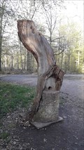 view gallery view gallerySW3.4 km |  Kamelleboom - Kottenforst, Germany Kamelleboom - Kottenforst, Germany
in Urban Legends and Superstitions DE: Alter Grenzbaum, um den sich die Legende rankt, er produziere Süßigkeiten für Kinder.
EN: Old border tree around which the legend is spread, it produces candy for children. posted by: Narayan, location: Nordrhein-Westfalen, Germany date approved: 03/09/2019 last visited: never |
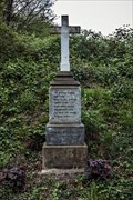 view gallery view galleryNE3.4 km | "Unglückskreuz" Bornheim-Uedorf, NRW, Germany in Christian Crosses A cross to the memory of a deadly car accident. posted by: argus1972 location: Nordrhein-Westfalen, Germany date approved: 04/19/2017 last visited: 03/14/2018 |
|