 view gallery view gallery NW4.8 km NW4.8 km
|   DO - Rue des Sablières - Coutiches ,France DO - Rue des Sablières - Coutiches ,France
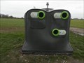
in Places for Recycling [EN] Recycling point for glass. [FR] Point de recyclage pour le verre. posted by:  pmaupin pmaupin location: Hauts-de-France, France date approved: 03/20/2020 last visited: 03/08/2020 |
 view gallery view gallery N5.1 km N5.1 km
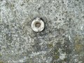
|  Benchmark Pont sur le "Courant de Coutiches" - Coutiches, France Benchmark Pont sur le "Courant de Coutiches" - Coutiches, France
in French Benchmarks Le repère cylindre se situe sur le parapet coté Coutiches posted by: geotrouvtou59 location: Hauts-de-France, France date approved: 05/24/2020 last visited: 05/21/2020 |
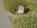 view gallery view galleryN5.3 km |  Borne d’entrée d’agglomération - Coutiches, France Borne d’entrée d’agglomération - Coutiches, France
in Milestones EN - Location or agglomeration entrance terminals.
FR - Bornes de localisation ou d’entrée d’agglomération. posted by: geotrouvtou59 location: Hauts-de-France, France date approved: 05/26/2020 last visited: 05/24/2020 |
 view gallery view gallery NE5.3 km NE5.3 km
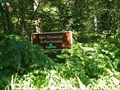
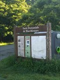
|  Forêt domaniale de Marchiennes - Marchiennes, France Forêt domaniale de Marchiennes - Marchiennes, France
in Public Access Lands FR - Propriété de l'abbaye de Marchiennes jusqu'en 1793 où elle devient propriété de l'État.
EN - Property of Marchiennes Abbey until 1793 when it became state property. posted by: geotrouvtou59 location: Hauts-de-France, France date approved: 08/23/2020 last visited: 08/23/2020 |
 view gallery view galleryNE5.3 km |  Forêt domaniale de Marchiennes - Marchiennes, France Forêt domaniale de Marchiennes - Marchiennes, France
in Wikipedia Entries FR - Propriété de l'abbaye de Marchiennes jusqu'en 1793 où elle devient propriété de l'État.
EN - Property of Marchiennes Abbey until 1793 when it became state property. posted by: geotrouvtou59 location: Hauts-de-France, France date approved: 07/30/2020 last visited: 07/28/2020 |
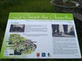
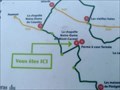
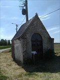
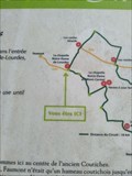
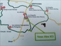 view gallery view galleryNW5.6 km |  Vous Etes Ici : La chapelle Notre-Dame-des-Fièvres - Coutiches, France Vous Etes Ici : La chapelle Notre-Dame-des-Fièvres - Coutiches, France
in 'You Are Here' Maps EN - Coutiches chapels circuit
FR - Circuit des chapelles Coutiches posted by: geotrouvtou59 location: Hauts-de-France, France date approved: 05/24/2020 last visited: 05/21/2020 |
 view gallery view galleryN5.6 km | ") Le Circuit des Chapelles - La chapelle Notre-Dame-de-Foy - Coutiches, France Le Circuit des Chapelles - La chapelle Notre-Dame-de-Foy - Coutiches, France
in Histoires de France (French historical markers) EN - The chapel was erected against a blockhouse around 1952 by the Hecquet-Lubrez family.
FR - La chapelle est érigée contre un blockhaus vers 1952 par la famille Hecquet-Lubrez. posted by: geotrouvtou59 location: Hauts-de-France, France date approved: 05/26/2020 last visited: 03/08/2020 |
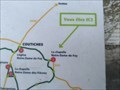 view gallery view galleryN5.6 km | Vous Etes Ici : La chapelle Notre-Dame-de-Foy - Coutiches, France in 'You Are Here' Maps EN - Coutiches chapels circuit
FR - Circuit des chapelles Coutiches posted by: geotrouvtou59 location: Hauts-de-France, France date approved: 05/24/2020 last visited: 05/21/2020 |
 view gallery view galleryN5.6 km |  La chapelle Notre-Dame-de-Foy - Coutiches, France La chapelle Notre-Dame-de-Foy - Coutiches, France
in Waychapels [EN] Chapel built in 1952, dedicated to Notre-Dame-de- Foy for priestly vocations.
[FR] Chapelle construite en 1952, dédiée à Notre-Dame-de-Foy pour les vocations sacerdotales. posted by: pmaupin location: Hauts-de-France, France date approved: 06/05/2020 last visited: 03/08/2020 |
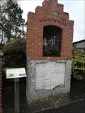
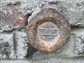
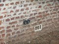
 view gallery view galleryN5.8 km | Benchmark - Au lieu-dit "Le Molinel", au n°58 - Coutiches, France in French Benchmarks Le Repère Cylindrique du Nivellement Général se situe sur le mur de façade de la grange côté "Coutiches, face à la route. posted by: pmaupin location: Hauts-de-France, France date approved: 03/09/2020 last visited: 05/23/2020 |
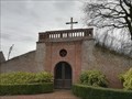 view gallery view galleryNW5.8 km | L'Oratoire - Coutiches, France in Waychapels [EN] In 1758, Antoine Constant de Hamel, Lord of Coutiches, ceded a plot of land for the construction of this Oratory (Chapel and Calvary).
[FR] En 1758, Antoine Constant de Hamel, seigneur de Coutiches, cède une parcelle de terrain pour la construction de cet Oratoire (Chapelle et Calvaire). posted by: pmaupin location: Hauts-de-France, France date approved: 06/05/2020 last visited: 03/08/2020 |
 view gallery view galleryNW5.8 km | Le Circuit des Chapelles - Le calvaire - Coutiches, France in Histoires de France (French historical markers) EN - Antoine Constant de Hamel, Lord of Coutiches, ceded a plot of land for the construction of a calvary.
FR - Antoine Constant de Hamel, seigneur de Coutiches, cède une parcelle de terrain pour la construction d'un calvaire. posted by: geotrouvtou59 location: Hauts-de-France, France date approved: 05/26/2020 last visited: 03/08/2020 |
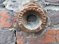
 view gallery view galleryNW6.1 km | Benchmark - Pont sur le"Courant de Coutiches" - Coutiches, France in French Benchmarks Le Repère Cylindrique du Nivellement Général se situe sur le parapet amont du pont, face à la route. posted by: pmaupin location: Hauts-de-France, France date approved: 03/09/2020 last visited: 05/23/2020 |
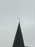 view gallery view galleryN6.3 km | Benchmark - Point Géodésique - Clocher de l'Église Notre-Dame-de-Foy - Coutiches, France in French Benchmarks Repère géodésique du point 1, à la base de la croix du clocher de l'église avec un Azimut de la prise de vue égal à 121 gr. posted by: pmaupin location: Hauts-de-France, France date approved: 03/09/2020 last visited: 05/23/2020 |
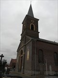
 view gallery view galleryN6.3 km |  Église Notre-Dame-de-Foy - Coutiches, France Église Notre-Dame-de-Foy - Coutiches, France
in Roman Catholic Churches [EN] Notre-Dame-de-Foy Church in Coutiches, neo-Romanesque and rebuilt in 1823 by Boulet, architect in Douai.
[FR] Église Notre-Dame-de-Foy de Coutiches, néo-romane et reconstruite en 1823 par Boulet, architecte à Douai. posted by: pmaupin location: Hauts-de-France, France date approved: 03/20/2020 last visited: 05/23/2020 |
 view gallery view galleryN6.3 km | Église Notre-Dame-de-Foy - Coutiches, France in This Old Church [EN] Notre-Dame-de-Foy Church in Coutiches, neo-Romanesque and rebuilt in 1823 by Boulet, architect in Douai. [FR] Église Notre-Dame-de-Foy de Coutiches, néo-romane et reconstruite en 1823 par Boulet, architecte à Douai. posted by: pmaupin location: Hauts-de-France, France date approved: 03/20/2020 last visited: 05/23/2020 |
 view gallery view galleryNE6.4 km | Vous Etes Ici : Forêt domaniale de Marchiennes - Marchiennes, France in 'You Are Here' Maps FR - Propriété de l'abbaye de Marchiennes jusqu'en 1793 où elle devient propriété de l'État.
EN - Property of Marchiennes Abbey until 1793 when it became state property. posted by: geotrouvtou59 location: Hauts-de-France, France date approved: 07/31/2020 last visited: 07/28/2020 |
 view gallery view galleryNW6.8 km | Vous Etes Ici : La chapelle Notre-Dame-du-Mont-Carmel - Coutiches, France in 'You Are Here' Maps EN - Coutiches chapels circuit
FR - Circuit des chapelles Coutiches posted by: geotrouvtou59 location: Hauts-de-France, France date approved: 05/22/2020 last visited: 05/21/2020 |
 view gallery view galleryNW6.8 km | La chapelle Notre-Dame-du-Mont-Carmel - Coutiches, France in Waychapels EN - Coutiches chapels circuit
FR - Circuit des chapelles Coutiches posted by: geotrouvtou59 location: Hauts-de-France, France date approved: 06/05/2020 last visited: 06/03/2020 |
 view gallery view galleryNE7.6 km | Benchmark Repère de nivellement BD - 215 Rue Albert Ricquier à BEUVRY-LA-FORET in French Benchmarks Benchmark du Nord
A 230 M AU NORD-OUEST DU CARREFOUR AVEC LA D.126, AU NO 724 ET 726 RUE ALBERT RICQUIER posted by: geotrouvtou59 location: Hauts-de-France, France date approved: 03/18/2017 last visited: 03/18/2017 |
 view gallery view galleryNE7.6 km | Benchmark Repère de nivellement BD - 216 Rue Albert Ricquier à BEUVRY-LA-FORET in French Benchmarks Benchmark du Nord
A 230 M AU NORD-OUEST DU CARREFOUR AVEC LA D.126, AU NO 724 ET 726 RUE ALBERT RICQUIER posted by: geotrouvtou59 location: Hauts-de-France, France date approved: 03/18/2017 last visited: 03/18/2017 |
 view gallery view galleryNW7.9 km | Vous Etes Ici : La chapelle Notre-Dame-de-Lourdes - Coutiches, France in 'You Are Here' Maps EN - Coutiches chapels circuit
FR - Circuit des chapelles Coutiches posted by: geotrouvtou59 location: Hauts-de-France, France date approved: 05/24/2020 last visited: 05/21/2020 |
 view gallery view gallery SW8.7 km SW8.7 km
|  Centre Historique Minier, Lawerde, France Centre Historique Minier, Lawerde, France
in Mines Le musée minier propose une immersion dans une mine de charbon / The mining museum offers an immersion in a coal mine posted by: GwenanDu location: Hauts-de-France, France date approved: 02/15/2020 last visited: 06/25/2020 |
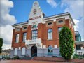 view gallery view gallery W9 km W9 km
|  Hôtel de ville - Waziers (Nord), France Hôtel de ville - Waziers (Nord), France
in Art Deco - Art Nouveau [FR] L’Hôtel de ville de Waziers a été construit au début des années 1930 sous la direction de Jean Goniaux. [EN] The town hall of Waziers was constructed at the beginning of the 1930s under the direction of Jean Goniaux. posted by: RakeInTheCache location: Hauts-de-France, France date approved: 05/24/2021 last visited: never |
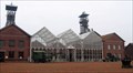
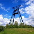 view gallery view galleryW9.3 km |  Chevalement de la fosse n°9 - Roost-Warendin (Nord), France, ID=1360-033 Chevalement de la fosse n°9 - Roost-Warendin (Nord), France, ID=1360-033
in World Heritage Sites [FR] Le chevalement est l'un des derniers vestiges de la Fosse 9 de l'Escarpelle, fermée en 1990. [EN] The headframe is one of the last vestiges of the l'Escarpelle number 9 mine. posted by: RakeInTheCache location: Hauts-de-France, France date approved: 05/23/2021 last visited: never |
|