 view gallery view gallery NW6.1 km NW6.1 km
|   Cimetière allemand de La Cambe - Normandie - France Cimetière allemand de La Cambe - Normandie - France
in Veteran Cemeteries [FR] Le cimetière militaire allemand de La Cambe fut inauguré le 21 Septembre 1961. [EN] Within a clearing dotted with trees and small dark stone crosses lie the remains of more than 21,000 German soldiers, sailors and airmen. posted by:  RakeInTheCache RakeInTheCache location: Normandie, France date approved: 10/02/2009 last visited: 08/30/2021 |
 view gallery view gallery W8.9 km W8.9 km
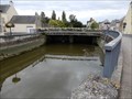
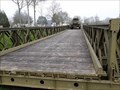
| ") Le pont au Douai - Isigny sur Mer, France Le pont au Douai - Isigny sur Mer, France
in Histoires de France (French historical markers) the Douet bridge with its doors to hold back the tide.
le pont du Douet avec ses portes pour retenir la marée. posted by: sara et gege location: Normandie, France date approved: 11/04/2020 last visited: 07/23/2021 |
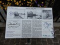
 view gallery view galleryW8.9 km |  Deux nouvelles portes à flots ont été installées à Isigny-sur-Mer, France Deux nouvelles portes à flots ont été installées à Isigny-sur-Mer, France
in News Article Locations The tidal gates below the bridge.
Les portes à marée en dessous du pont. posted by: sara et gege location: Normandie, France date approved: 11/04/2020 last visited: 07/23/2021 |
 view gallery view galleryW9 km |  Plaque Liberation de la ville - Isigny sur Mer, France Plaque Liberation de la ville - Isigny sur Mer, France
in World War II Memorials / Monuments A plaque for the liberation of the city next to the bridge.
Une plaque pour la libération de la ville a coté du pont. posted by: sara et gege location: Normandie, France date approved: 11/04/2020 last visited: 07/23/2021 |
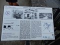
 view gallery view galleryW9 km | Les Guideaux - Isigny sur Mer, France in Histoires de France (French historical markers) the port of Isigny along the Aure.
le port d'Isigny le long de l'Aure. posted by: sara et gege location: Normandie, France date approved: 11/04/2020 last visited: 07/23/2021 |
 view gallery view galleryW9 km |  Eglise St Georges - Isigny sur Mer, France Eglise St Georges - Isigny sur Mer, France
in Medieval Churches [FR] La construction de l'église Saint-Georges remonte au XIIIe siècle.
[EN] The construction of St. George's Church dates back to the 13th century. posted by: Marcus14123 location: Normandie, France date approved: 12/28/2018 last visited: 12/27/2018 |
 view gallery view gallery NE10.8 km NE10.8 km
| Overlord Museum - Colleville sur Mer - France in News Article Locations Overlord Museum retrace cette période du Débarquement allié jusqu'à la libération de Paris.
Overlord Museum chronicles the period of the Allied landing until the liberation of Paris. posted by: Alfouine location: Normandie, France date approved: 07/30/2017 last visited: 10/29/2022 |
 view gallery view galleryNE10.8 km |  Overlord Museum - Colleville sur Mer - France Overlord Museum - Colleville sur Mer - France
in War and Military Museums Overlord Museum retrace cette période du Débarquement allié jusqu'à la libération de Paris.
Overlord Museum chronicles the period of the Allied landing until the liberation of Paris. posted by: Alfouine location: Normandie, France date approved: 08/03/2017 last visited: 03/25/2023 |
 view gallery view galleryNE10.8 km |  Overlord Museum.Colleville-sur-Mer. France Overlord Museum.Colleville-sur-Mer. France
in Bailey Bridges Un pont Bailey installé à l'Overlord Museum /A Bailey Bridge at the Overlord Museum posted by: celene37 location: Normandie, France date approved: 04/15/2018 last visited: 10/27/2022 |
 view gallery view gallery N10.8 km N10.8 km
|  You Are Here - Pointe Du Hoc, France You Are Here - Pointe Du Hoc, France
in 'You Are Here' Maps You Are Here [French: VOUS ETES ICI] in front of Pointe Du Hoc Memorial and Museum. posted by: ToRo61 location: Normandie, France date approved: 09/01/2014 last visited: 11/05/2022 |
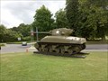 view gallery view galleryNE10.8 km |  Sherman M4 - Colleville sur Mer - France Sherman M4 - Colleville sur Mer - France
in Military Ground Equipment Displays Un exemplaire de char Sherman utilisé pendant la deuxième guerre mondiale lors de l'opération Overlord.
A copy of Sherman tank used during World War II during Operation Overlord. posted by: Alfouine location: Normandie, France date approved: 07/29/2017 last visited: 10/28/2022 |
 view gallery view galleryN10.8 km |  Visitor Center at Pointe du Hoc - Normandy - France Visitor Center at Pointe du Hoc - Normandy - France
in Tourist Information Centers - Visitor Centers The visitor center at the Pointe du Hoc seems quite new but unlike the one at the American Cemetery, it has yet to find its mission in life. (As of 2009) posted by: RakeInTheCache location: Normandie, France date approved: 09/29/2009 last visited: 06/22/2022 |
 view gallery view galleryN10.8 km |  World Peace Monument - Grandcamp-Maisy, France World Peace Monument - Grandcamp-Maisy, France
in Doves of peace The Peace Monument made by the Chinese artist Yao Yuan was unveiled on June 3rd, 2004. posted by: Walking Boots location: Normandie, France date approved: 10/03/2022 last visited: 10/26/2022 |
 view gallery view galleryN10.8 km |  World Peace Statue - Grandcamp-Maisy, France World Peace Statue - Grandcamp-Maisy, France
in Peace Memorials The Peace Monument made by the Chinese artist Yao Yuan was unveiled on June 3rd, 2004. posted by: Walking Boots location: Normandie, France date approved: 07/08/2022 last visited: 10/26/2022 |
 view gallery view galleryN10.9 km |  Orientation Table - Pointe Du Hoc, France Orientation Table - Pointe Du Hoc, France
in Orientation Tables This table describes assault and commemorates the American Second Ranger Battalion who fought there on 6 June 1944 as part of the D-Day landings in World War II. posted by: ToRo61 location: Normandie, France date approved: 09/01/2014 last visited: 06/22/2022 |
 view gallery view galleryN11.1 km | Pointe du Hoc (Calvados, Normandy, France) in World War II Sites ...today quiet cliff covered by grass with concrete ruins and offering great vista over Canal, but in June 1944, during Operation Overlord, Point du Hoc was witness of brave attack of the United States Army Rangers. posted by: Dorcadion Team location: Normandie, France date approved: 06/10/2009 last visited: 06/22/2022 |
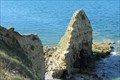 view gallery view galleryN11.1 km |  La Pointe du Hoc - Cricqueville-en-Bessin, France La Pointe du Hoc - Cricqueville-en-Bessin, France
in Wikipedia Entries [EN] It consists of a cliff 25 to 30 meters high preceded by a needle that advances into the sea and it overlooks a pebble beach about ten meters wide at its feet.
[FR]Elle se compose d'une falaise de 25 à 30 mètres de haut précédée d'une aiguille qui s'avance dans la mer et elle surplombe une plage de galets d'une dizaine de mètres de large à ses pieds. posted by: pmaupin location: Normandie, France date approved: 08/04/2018 last visited: 06/22/2022 |
 view gallery view galleryN11.1 km |  La Pointe du Hoc - Cricqueville-en-Bessin, France La Pointe du Hoc - Cricqueville-en-Bessin, France
in Official Local Tourism Attractions [EN] It consists of a cliff 25 to 30 meters high preceded by a needle that advances into the sea and it overlooks a pebble beach about ten meters wide at its feet. [FR]Elle se compose d'une falaise de 25 à 30 mètres de haut précédée d'une aiguille qui s'avance dans la mer et elle surplombe une plage de galets d'une dizaine de mètres de large à ses pieds. posted by: pmaupin location: Normandie, France date approved: 10/15/2018 last visited: 06/22/2022 |
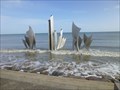
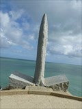
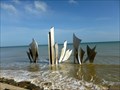 view gallery view galleryNE11.1 km |  Les Braves - Omaha Beach - Vierville-sur-Mer, France Les Braves - Omaha Beach - Vierville-sur-Mer, France
in Abstract Public Sculptures Les Braves is an abstract sculpture located on Omaha Beach in the town of Vierville-sur-Mer on the coast of Normandy, France. posted by:  neoc1 neoc1 location: Normandie, France date approved: 04/24/2013 last visited: 05/18/2023 |
 view gallery view galleryNE11.1 km |  Omaha Beach - Normandy, France Omaha Beach - Normandy, France
in Battlefields The World War II battle of Omaha Beach took place on June 6, 1944 during the allied invasion of German occupied France by American troops. posted by: neoc1 location: Normandie, France date approved: 12/27/2019 last visited: 05/18/2023 |
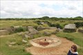 view gallery view galleryN11.1 km | Pointe-du-Hoc Battlefield - Cricqueville-en-Bessin, Basse-Normandie, France in Battlefields During WWII D-Day Landings, US Forces bombed and climbed Pointe-du-Hoc to take over a German fortification. // Pendant WWII, les forces américaines ont bombardé et monta Pointe-du-Hoc de prendre en charge une fortification allemande. posted by: Trail Blaisers location: Normandie, France date approved: 07/20/2015 last visited: 06/22/2022 |
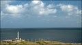
 view gallery view galleryN11.3 km |  Pointe Du Hoc, France Pointe Du Hoc, France
in Scenic Overlooks Pointe du Hoc is a promontory with a 100 ft cliff overlooking the English Channel on the coast of Normandy in northern France. posted by: ToRo61 location: Normandie, France date approved: 09/02/2014 last visited: 06/22/2022 |
 view gallery view galleryN11.3 km |  Rangers Lead the Way - Pointe-du-Hoc, France Rangers Lead the Way - Pointe-du-Hoc, France
in There's a Book About It The book 'Rangers Lead the Way – Pointe-du-Hoc D-Day 1944' describes a
legendary raid of the US Army 2nd Rangers Battalion during World War II. posted by: ToRo61 location: Normandie, France date approved: 12/14/2014 last visited: 06/22/2022 |
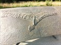
 view gallery view galleryN11.3 km | Ranger Commandoes 116th U.S. Infantry - Pointe du Hoc, Normandy, France in Specific Veteran Memorials A granite monument in the form of a grappling hook honors the Ranger Commandos of the 116th Infantry under the command of Colonel James E. Rudder. posted by: neoc1 location: Normandie, France date approved: 03/22/2017 last visited: 06/22/2022 |
 view gallery view galleryN11.3 km | Pointe du Hoc Ranger Monument - Pointe Du Hoc, France in World War II Memorials / Monuments A granite monument in the form of a grappling hook honors the Ranger Commandos of the 116th Infantry under the command of Colonel James E. Rudder. posted by: neoc1 location: Normandie, France date approved: 04/29/2013 last visited: 06/22/2022 |
|