 view gallery view gallery NE6.6 km NE6.6 km
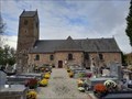
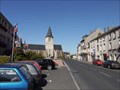
|   Église Saint-Sauveur - Saint-Sauveur-la-Pommeraye, France Église Saint-Sauveur - Saint-Sauveur-la-Pommeraye, France
in Roman Catholic Churches [EN] 16th century church with its listed altarpiece in a small village in Normandy.
[FR] Église du XVIe siècle avec son retable classé dans un petit village de Normandie posted by:  pmaupin pmaupin location: Normandie, France date approved: 11/05/2022 last visited: 11/03/2022 |
 view gallery view galleryNE6.6 km | Église Saint-Sauveur - Saint-Sauveur-la-Pommeraye, France in This Old Church [EN] 16th century church with its listed altarpiece in a small village in Normandy. [FR] Église du XVIe siècle avec son retable classé dans un petit village de Normandie posted by: pmaupin location: Normandie, France date approved: 11/03/2022 last visited: 11/03/2022 |
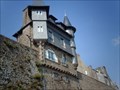
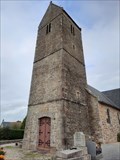 view gallery view galleryNE6.6 km |  Le Clocher de l'Église Saint-Sauveur - Saint-Sauveur-la-Pommeraye, France Le Clocher de l'Église Saint-Sauveur - Saint-Sauveur-la-Pommeraye, France
in Bell Towers [EN] 16th century church with its listed altarpiece in a small village in Normandy. [FR] Église du XVIe siècle avec son retable classé dans un petit village de Normandie posted by: pmaupin location: Normandie, France date approved: 11/04/2022 last visited: 11/04/2022 |
 view gallery view gallery SW7.1 km SW7.1 km
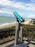
|  Cliff top binoculars, Carolles, Manche, France Cliff top binoculars, Carolles, Manche, France
in Coin-Op Binoculars Clifftop binoculars near Carolles, Manche. There are views towards Granville to the North and West out to sea. posted by:  Team Sieni Team Sieni location: France date approved: 10/26/2009 last visited: 01/22/2012 |
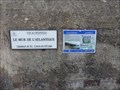
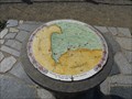 view gallery view gallerySW7.1 km |  Table d'orientation, Carolles, Manche, France Table d'orientation, Carolles, Manche, France
in Orientation Tables An enamelled table describing the South-Westerly view out to sea towards the Northern coast of Britanny, and towards Granville in the North.
posted by: Team Sieni location: France date approved: 10/24/2009 last visited: 01/22/2012 |
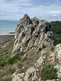 view gallery view gallerySW7.7 km |  Le rocher du diable - Carolles - France Le rocher du diable - Carolles - France
in Geological Devilish Locations Le rocher du Diable, chaise du diable ou chapeau de Napoléon, est une curiosité naturelle située à Carolles.
Culminant à 70 mètres, dans les falaises de Carolles, en bordure du GR 223, il domine la vallée du Lude et la baie du Mont Saint Michel. posted by: Alfouine location: Normandie, France date approved: 08/30/2021 last visited: never |
 view gallery view gallery NW7.9 km NW7.9 km
|  Office de Tourisme Donville sur Mer, France Office de Tourisme Donville sur Mer, France
in Tourist Information Centers - Visitor Centers the tourist office is next to the town hall.
l'office de Tourisme est a coté de la mairie. posted by: sara et gege location: Normandie, France date approved: 10/31/2020 last visited: 09/09/2021 |
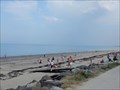 view gallery view galleryNW8.5 km |  Plage de Donville sur Mer, France Plage de Donville sur Mer, France
in Beaches a very beautiful and large beach.
une tres belle et grande plage. posted by: sara et gege location: Normandie, France date approved: 11/03/2020 last visited: 09/09/2021 |
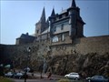 view gallery view galleryNW8.5 km |  Enceinte de la Haute-Ville - Grandville, France Enceinte de la Haute-Ville - Grandville, France
in Monuments Historiques Français FR - Les remparts établis au 15e siècle lors de la fondation de la ville.
EN - The ramparts established in the 15th century when the city was founded. posted by: geotrouvtou59 location: Normandie, France date approved: 04/06/2020 last visited: 01/03/2006 |
 view gallery view galleryNW8.5 km |  Enceinte de la Haute-Ville - Grandville, France Enceinte de la Haute-Ville - Grandville, France
in Wikipedia Entries FR - Les remparts établis au 15e siècle lors de la fondation de la ville.
EN - The ramparts established in the 15th century when the city was founded. posted by: geotrouvtou59 location: Normandie, France date approved: 04/06/2020 last visited: 01/03/2006 |
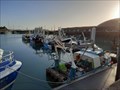 view gallery view galleryNW8.5 km |  Port de pêche de Granville - Granville, France Port de pêche de Granville - Granville, France
in Commercial Fishing Ports [EN] The fishing port of Granville is the second largest fishing port in the Channel.
[FR] Le port de pêche de Granville est le deuxième port de pêche de la Manche. posted by: pmaupin location: Normandie, France date approved: 11/27/2022 last visited: 11/27/2022 |
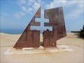
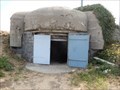
 view gallery view galleryNW9 km |  Mur de l Atlantique pointe du Roc - Granville, France Mur de l Atlantique pointe du Roc - Granville, France
in World War II Sites a blockhauss from the Atlantic Wall to Pointe du Roc.
un blockhauss du mur de l'Atlantique à la pointe du Roc. posted by: sara et gege location: Normandie, France date approved: 10/29/2020 last visited: 09/20/2021 |
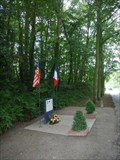
 view gallery view galleryNW9 km | Monument aux Résistants pointe du Roc - Granville, France in World War II Memorials / Monuments A monument in homage to resistance fighters.
Un monument en hommage aux résistants. posted by: sara et gege location: Normandie, France date approved: 10/30/2020 last visited: 09/20/2021 |
 view gallery view galleryNW9 km |  Granville. Le nouveau monument d’hommage aux Français libres sera inauguré mardi 23 juillet, France Granville. Le nouveau monument d’hommage aux Français libres sera inauguré mardi 23 juillet, France
in News Article Locations A monument in homage to resistance fighters.
Un monument en hommage aux résistants. posted by: sara et gege location: Normandie, France date approved: 10/29/2020 last visited: 09/21/2021 |
 view gallery view galleryNW9 km | Batterie d'artillerie du Roc - Granville France in Monuments Historiques Français the advanced defense battery.
la batterie de defense de la pointe. posted by: sara et gege location: Normandie, France date approved: 10/29/2020 last visited: 09/20/2021 |
 view gallery view galleryNW9.2 km | Phare de Granville, France in Wikipedia Entries the Pointe du Roc lighthouse.
le phare de la pointe du Roc. posted by: sara et gege location: Normandie, France date approved: 10/29/2020 last visited: 09/20/2021 |
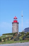 view gallery view galleryNW9.2 km | Phare du Cap Lihou- Granville, France in Monuments Historiques Français the Pointe du Roc lighthouse.
le phare de la pointe du Roc. posted by: sara et gege location: Normandie, France date approved: 10/29/2020 last visited: 09/20/2021 |
 view gallery view gallery N9.7 km N9.7 km
| US Memorial, Bréhal, Manche, France in World War II Memorials / Monuments Memorial to Charles Stone, US airman shot down on D-Day, and to Arthur Muthig and Berlin Fenton of the 86th Cavalry Reconnaissance Squadron, killed on 30th of July 1944, the day of the liberation of Bréhal. posted by: Team Sieni location: France date approved: 07/16/2011 last visited: 01/22/2012 |
 view gallery view galleryN11.7 km |  Chanteloup, Manche, Normandy Chanteloup, Manche, Normandy
in Sundials Walking through the village of Chanteloup, in Normandy I spotted this sundial on a residential property. posted by: Team Sieni location: France date approved: 04/09/2007 last visited: 01/22/2012 |
 view gallery view galleryN13.8 km | L'Église de Notre Dame, Cérences, Manche, France in This Old Church L'Église de Notre Dame in Cérences was built in the 12 century, and significantly modified in the 18th. The date 1757 is inscribed over one of the doors. posted by: Team Sieni location: France date approved: 09/06/2009 last visited: 01/22/2012 |
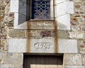 view gallery view galleryN13.8 km |  1757 - L'Église de Notre Dame, Cérences, Manche, France 1757 - L'Église de Notre Dame, Cérences, Manche, France
in Dated Buildings and Cornerstones L'Église de Notre Dame Cérences was built in the 12 century, and significantly modified in the 18th. The date 1757 is inscribed over one of the doors. posted by: Team Sieni location: France date approved: 09/06/2009 last visited: 01/22/2012 |
 view gallery view gallery S15.6 km S15.6 km
| Tombelaine - Genêts, France in Wikipedia Entries [EN] Tombelaine is a granite islet located in the bay of Mont-Saint-Michel, on the right bank of the coastal river Sée, a few kilometers north of Mont Saint-Michel.
[FR] Tombelaine est un îlot granitique situé dans la baie du Mont-Saint-Michel, sur la rive droite du fleuve côtier de la Sée, à quelques kilomètres au nord du mont Saint-Michel. posted by: pmaupin location: Normandie, France date approved: 07/08/2020 last visited: 05/16/2023 |
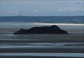 view gallery view galleryS15.6 km | Ilot de Tombelaine - Genêts, France in Monuments Historiques Français [FR] Tombelaine est un îlot granitique situé dans la baie du Mont-Saint-Michel, sur la rive droite du fleuve côtier de la Sée, à quelques kilomètres au nord du mont Saint-Michel.
[EN] Tombelaine is a granite islet located in the bay of Mont-Saint-Michel, on the right bank of the coastal river Sée, a few kilometers north of Mont Saint-Michel. posted by: pmaupin location: Normandie, France date approved: 07/08/2020 last visited: 05/16/2023 |
 view gallery view galleryS15.6 km |  Rocher Tombelaine - Genêts, France Rocher Tombelaine - Genêts, France
in Satellite Imagery Oddities [EN] Tombelaine is a granite islet located in the bay of Mont-Saint-Michel, on the right bank of the coastal river Sée, a few kilometers north of Mont Saint-Michel. [FR] Tombelaine est un îlot granitique situé dans la baie du Mont-Saint-Michel, sur la rive droite du fleuve côtier de la Sée, à quelques kilomètres au nord du mont Saint-Michel. posted by: pmaupin location: Normandie, France date approved: 07/08/2020 last visited: 05/16/2023 |
 view gallery view gallery SE16.1 km SE16.1 km
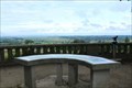
| Table d'orientation au Jardin des Plantes - Avranches, France in Orientation Tables [EN] A beautiful orientation table on the belvedere of the Jardin des Plantes d'Avranches.
[FR] Une belle table d'orientation sur le belvédère du Jardin des Plantes d'Avranches. posted by: pmaupin location: Normandie, France date approved: 07/26/2020 last visited: 08/29/2021 |
|