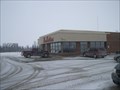
 view gallery view gallery W4.2 km W4.2 km
|   Tim Hortons Parkhill Ontario Tim Hortons Parkhill Ontario
in Tim Horton's Restaurants Tim Hortons establishment located just outside of Parkhill Ontario posted by:  Knightwatchman Knightwatchman location: Ontario, Canada date approved: 01/02/2009 last visited: 12/04/2011 |
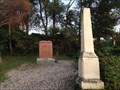
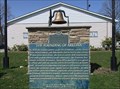
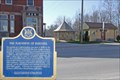 view gallery view galleryW4.3 km |  The Founding of Parkhill The Founding of Parkhill
in Ontario Provincial Plaques Parkhill owes its beginning to the coming of the Great Western railway. In 1859, the Grand Trunk Railway completed a line from St. Mary's to Point Edward. The following year the first Post Office and store were opened at the present site of Parkhill. posted by:  Hard Oiler Hard Oiler location: Ontario, Canada date approved: 04/19/2006 last visited: 11/22/2022 |
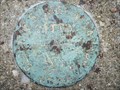 view gallery view galleryW4.5 km |  Parkhill Geodetic Survey Marker 27U1706 Parkhill Geodetic Survey Marker 27U1706
in Canadian Benchmarks Fundamental Benchmark mounted on the top of a concrete tablet. posted by: Cargoman location: Ontario, Canada date approved: 12/30/2008 last visited: 03/13/2020 |
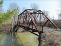
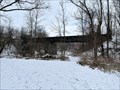 view gallery view gallery E7.1 km E7.1 km
|  Ailsa Craig Rail Bridge - Aisla Craig, ON Ailsa Craig Rail Bridge - Aisla Craig, ON
in Railroad Bridges Former railroad bridge in Ailsa Craig posted by: stinger503 location: Ontario, Canada date approved: 02/23/2024 last visited: never |
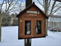 view gallery view galleryE7.4 km |  Ailsa Craig Lions Box Exchange - Ailsa Craig, ON Ailsa Craig Lions Box Exchange - Ailsa Craig, ON
in Free Community Book Exchanges Community Book Exchange at Lions Park posted by: stinger503 location: Ontario, Canada date approved: 02/23/2024 last visited: never |
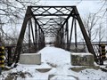
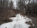 view gallery view gallery SE7.9 km SE7.9 km
|  The Nairn Bridge The Nairn Bridge
in Orphaned Bridges A narrow one-lane bridge with iron sides and a cement deck over a stream. An abandon piece or road, equally narrow winds down the hill, over the bridge and off out to the west. The road dead ends on both sides of the valley. posted by: DNStephens location: Ontario, Canada date approved: 03/22/2011 last visited: 03/24/2011 |
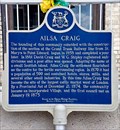 view gallery view galleryE7.9 km | "AILSA CRAIG" in Ontario Provincial Plaques Named after a small island off the coast of Scotland, Ailsa Craig owes its existence to the Grand Trunk Railroad when it was extended from St Mary's to Sarnia in 1858 posted by: Hard Oiler location: Ontario, Canada date approved: 07/29/2007 last visited: 10/15/2022 |
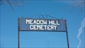 view gallery view gallery NW8 km NW8 km
|  Meadow Hill Cemetery Meadow Hill Cemetery
in Worldwide Cemeteries A small cemetery along W Corner Drive - Parkhill posted by: 3Nish location: Ontario, Canada date approved: 11/09/2011 last visited: never |
 view gallery view gallerySE8.2 km | McTaggart Cemetery - Ailsa Craig, ON in Worldwide Cemeteries Small pioneer cemetery near Ailsa Craig posted by: stinger503 location: Ontario, Canada date approved: 08/03/2018 last visited: never |
 view gallery view gallery SW11.4 km SW11.4 km
| River Road Bridge - Middlesex County, Ontario in Orphaned Bridges This abandoned bridge is located on River Dr. near Kerwood Rd.(CR6)in a very rural area between the communities of Thedford and Ailsa Craig in Middlesex County, posted by: DougandSandra location: Ontario, Canada date approved: 05/09/2014 last visited: 10/15/2012 |
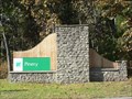
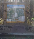 view gallery view galleryW13.2 km |  Joany's Woods Trail Head Joany's Woods Trail Head
in Hiking and walking trailheads This trailhead is located at the end of a No Winter Maintenance Road. posted by: 3Nish location: Ontario, Canada date approved: 11/05/2011 last visited: 12/14/2011 |
 view gallery view gallery N15.4 km N15.4 km
|  Starlite Drive-In Theatre; Shipka, Ontario, Canada Starlite Drive-In Theatre; Shipka, Ontario, Canada
in Drive-In Movie Theaters A still thriving drive-in located in Shipka near Grand Bend Ontario. posted by: Hard Oiler location: Ontario, Canada date approved: 04/19/2006 last visited: 09/30/2012 |
 view gallery view galleryW15.8 km |  River Road Bridge - Thedford, ON River Road Bridge - Thedford, ON
in Truss Bridges Old Truss Bridge crossing the Ausable posted by: stinger503 location: Ontario, Canada date approved: 02/26/2024 last visited: never |
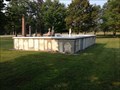
 view gallery view galleryW16.6 km | Pinehill Cemetery, Lambton County in Worldwide Cemeteries Established in 1853, by the early pioneer settlers. It has been expanded 4 times. In 1975, Fred Walden donated a 2 acre extention. A memorial to the pioneers was erected by the Walden Family in 1992. posted by: 3-Bearss location: Ontario, Canada date approved: 08/12/2010 last visited: 10/16/2008 |
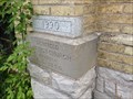 view gallery view galleryE16.6 km |  1890 - Denfield Baptist Church, Denfield, ON 1890 - Denfield Baptist Church, Denfield, ON
in Dated Buildings and Cornerstones Historic church building in Denfield posted by: stinger503 location: Ontario, Canada date approved: 07/22/2022 last visited: never |
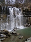 view gallery view gallerySW16.9 km |  Rock Glen Falls - Arkona, Ontario Rock Glen Falls - Arkona, Ontario
in Waterfalls The Rock Glen Falls are located in the Rock Glen Conservation Area - 8680 Rock Glen Road, Arkona, Ontario.
An entry fee will need to be paid to enter the park. posted by: brenda&&rew location: Ontario, Canada date approved: 02/27/2010 last visited: 12/22/2022 |
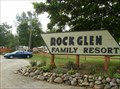 view gallery view gallerySW16.9 km |  Rock Glen Family Resort - Arkona, Ontario Rock Glen Family Resort - Arkona, Ontario
in Campgrounds A Family Campground and Resort in Arkona, Ontario. posted by: allie_gator2006 location: Ontario, Canada date approved: 09/15/2010 last visited: 12/25/2012 |
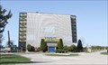
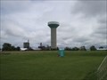
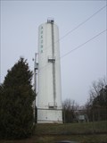 view gallery view gallerySW17.9 km |  Arkona Standpipe Arkona Standpipe
in Water Towers Small town...Big standpipe. posted by: Cargoman location: Ontario, Canada date approved: 02/14/2009 last visited: never |
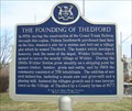 view gallery view galleryW18.2 km | The Founding of Thedford in Ontario Provincial Plaques This plaque recognizes the founding of Thedford when, in 1859, the Grand Trunk Railway finished the rail line from St Mary’s to Point Edward and established a station stop near here. posted by: Hard Oiler location: Ontario, Canada date approved: 04/19/2006 last visited: 12/25/2012 |
 view gallery view gallerySE18.2 km | Poplar Hill Cemetery - Poplar Hill, ON in Worldwide Cemeteries Main cemetery for the Poplar Hill community posted by: stinger503 location: Ontario, Canada date approved: 08/06/2018 last visited: 04/28/2021 |
 view gallery view gallerySE18.3 km | Hume Cemetery - Coldstream, ON in Worldwide Cemeteries Small pioneer cemetery near Coldstream posted by: stinger503 location: Ontario, Canada date approved: 08/03/2018 last visited: 04/24/2022 |
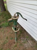 view gallery view gallerySE18.3 km |  Water Pump - Poplar Hill Cemetery - Middlesex County, Ontario Water Pump - Poplar Hill Cemetery - Middlesex County, Ontario
in Hand Operated Water Pumps A hand-operated water pump on the grounds of the Poplar Hill Cemetery, about 25 km West of London, Ontario near Poplar Hill. posted by: m0bean location: Ontario, Canada date approved: 08/20/2022 last visited: never |
 view gallery view gallerySW18.3 km | The Founding of Arkona in Ontario Provincial Plaques This plaque recognizes the founding of Arkona, a small farming community situated on what was once an important road junction halfway between London and Sarnia. posted by: Hard Oiler location: Ontario, Canada date approved: 04/19/2006 last visited: 12/22/2022 |
 view gallery view galleryE18.7 km | Lucan Water Tower in Water Towers Concrete water tower near Lucan Community Centre. posted by: Cargoman location: Ontario, Canada date approved: 06/30/2008 last visited: 08/04/2016 |
 view gallery view galleryNW18.8 km |  The Pinery Provincial Park - Ontario The Pinery Provincial Park - Ontario
in State/Provincial Parks The Pinery is an Ontario Provincial Park, it is rated one of the top five in Ontario. posted by: NFJK location: Ontario, Canada date approved: 09/26/2012 last visited: 08/16/2016 |
|