 view gallery view gallery S31.5 km S31.5 km
|   Jireh, WY Jireh, WY
in Ghost Towns A Wyoming Historical Marker commemorates the now-vanished town of Jireh, as well as the college that was established there. Located on the south side of US 18/20, almost fifeen miles west of Lusk. posted by:  QuarrellaDeVil QuarrellaDeVil location: Wyoming date approved: 10/12/2015 last visited: 05/03/2019 |
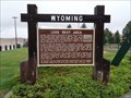
 view gallery view galleryS31.5 km |  Jireh Jireh
in Wyoming Historical Markers Wyoming Historical Marker noting the establishment of the Jireh settlement, which grew into a college and a town. Located on the south side of US 18/20, almost fifteen miles west of Lusk. posted by: QuarrellaDeVil location: Wyoming date approved: 09/30/2015 last visited: 05/03/2019 |
 view gallery view gallery SE35.4 km SE35.4 km
|  CNW 10380 - Lusk, WY CNW 10380 - Lusk, WY
in Train Cabooses A CNW caboose on roadside display in a small Wyoming town. posted by:  Telomere Telomere location: Wyoming date approved: 11/01/2016 last visited: never |
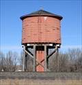 view gallery view gallerySE36 km |  Lusk RR Water Tank, Lusk, WY Lusk RR Water Tank, Lusk, WY
in Water Towers Along side the railroad, an old tank made of redwood. posted by: ronjean location: Wyoming date approved: 11/27/2017 last visited: never |
 view gallery view gallerySE36 km | Cheyenne-Deadwood Trail - Lusk, WY in Wyoming Historical Markers A historical marker at the rest area on the south side of US 18/20, a little over two miles southwest of Lusk, provides some history of the Cheyenne-Deadwood Trail, which passed right through where you're standing. posted by: QuarrellaDeVil location: Wyoming date approved: 05/24/2020 last visited: never |
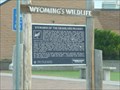
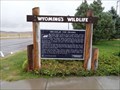 view gallery view gallerySE36 km | Breaks in the Prairie - Lusk, WY in Wyoming Historical Markers A Wyoming's Wildlife marker at the rest area on the south side of US 18/20, a little over two miles southwest of Lusk, provides some background about the wildlife you'll see in the area. posted by: QuarrellaDeVil location: Wyoming date approved: 05/24/2020 last visited: never |
 view gallery view gallerySE36 km |  Breaks in the Prairie - Lusk, WY Breaks in the Prairie - Lusk, WY
in Flora and Fauna Information Signs A Wyoming's Wildlife sign at the rest area on the south side of US 18/20, a little over two miles southwest of Lusk, provides some background about the wildlife you'll see in the area. posted by: QuarrellaDeVil location: Wyoming date approved: 05/25/2020 last visited: never |
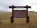
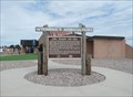
 view gallery view gallerySE36 km | Lusk Rest Area - Lusk, WY in Wyoming Historical Markers Wyoming Historical Marker at the rest area on the south side of US 18/20, a little over two miles southwest of Lusk, providing some history of this, Wyoming's first roadside beautification area, still blazing trails in the 21st century. posted by: QuarrellaDeVil location: Wyoming date approved: 05/22/2020 last visited: never |
 view gallery view gallerySE36 km |  Wyoming's FIRST Roadside Beautification Area - Lusk, WY Wyoming's FIRST Roadside Beautification Area - Lusk, WY
in First of its Kind A Wyoming Historical Marker at the rest area on the south side of US 18/20, a little over two miles southwest of Lusk, notes this as Wyoming's first roadside beautification area, still blazing trails in the 21st century. posted by: QuarrellaDeVil location: Wyoming date approved: 05/22/2020 last visited: never |
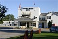 view gallery view gallerySE36.2 km |  The Covered Wagon Motel -- Lusk WY The Covered Wagon Motel -- Lusk WY
in Covered Wagons Blasterz LOVE the Covered Wagon Motel in Lusk - we stay here everytime we are in the area. posted by: Benchmark Blasterz location: Wyoming date approved: 02/22/2013 last visited: 02/02/2013 |
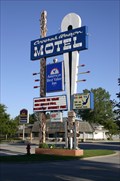 view gallery view gallerySE36.2 km |  The Covered Wagon Motel -- Lusk WY The Covered Wagon Motel -- Lusk WY
in Recommended Accommodation The Covered Wagon is a historic motel now part of the America's Best Value Inn group. posted by: Benchmark Blasterz location: Wyoming date approved: 02/12/2013 last visited: 08/08/2009 |
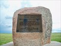 view gallery view gallerySE39.8 km | Texas Trail Monument - Lusk, WY in Wyoming Historical Markers A simple monument describing the early cattle history of this part of Wyoming. posted by: cldisme location: Wyoming date approved: 07/14/2014 last visited: never |
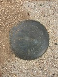
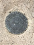
 view gallery view gallery NW49.7 km NW49.7 km
|  T40N R68W S28 S27 S34 S33 - Converse County, Wyoming T40N R68W S28 S27 S34 S33 - Converse County, Wyoming
in Public Land Survey Marks A section corner marker in the vicinity of Dull Center in northern Converse County. posted by: Tom.dog location: Wyoming date approved: 04/08/2024 last visited: never |
 view gallery view gallery NE51.2 km NE51.2 km
| Cows, Wildlife and Gold in Wyoming Historical Markers This Wyoming Historical Marker is one of two at the Mule Creek Junction Rest Area at Hwy 18 & 85 about 45 miles north of Lusk, Wyoming. posted by: PeterNoG location: Wyoming date approved: 11/09/2016 last visited: 09/30/2016 |
 view gallery view galleryNE51.2 km | Stewards of the Grassland Prairies in Wyoming Historical Markers This Wyoming Historical Marker is one of two at the Mule Creek Junction Rest Area at Hwy 18 & 85 about 45 miles north of Lusk, Wyoming. posted by: PeterNoG location: Wyoming date approved: 11/09/2016 last visited: 09/30/2016 |
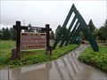
 view gallery view galleryNE51.2 km |  Highway 18 & 85 Rest Area, Mule Creek Junction, Wyoming Highway 18 & 85 Rest Area, Mule Creek Junction, Wyoming
in Blue Star Memorial Highway Markers The Blue Star Memorial Marker Program was adopted in 1945 by National Garden Clubs, Inc. (formerly National Council Of State Garden Clubs, Inc.), to honor the men and women of the Armed Forces of WWII. posted by: MNSearchers location: Wyoming date approved: 08/11/2006 last visited: 07/22/2007 |
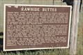 view gallery view galleryS51.8 km | Rawhide Buttes - Lusk, WY in Wyoming Historical Markers This location served as a stage station for 11 years. posted by: Go Boilers! location: Wyoming date approved: 08/04/2016 last visited: never |
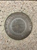
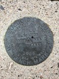
 view gallery view gallery SW52.3 km SW52.3 km
|  SYBRANT NO 2 - Converse County, Wyoming SYBRANT NO 2 - Converse County, Wyoming
in U.S. Benchmarks Reference mark 2 for USGS benchmark SYBRANT (NQ0535). posted by: Tom.dog location: Wyoming date approved: 01/07/2023 last visited: never |
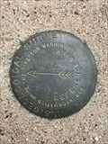
 view gallery view gallerySW52.3 km | SYBRANT (NQ0535) - Converse County, Wyoming in U.S. Benchmarks A USGS benchmark on top of a hill to the north of Douglas, Wyoming. posted by: Tom.dog location: Wyoming date approved: 01/07/2023 last visited: never |
 view gallery view gallerySW52.3 km | SYBRANT NO 1 - Converse County, Wyoming in U.S. Benchmarks Reference mark 1 for USGS benchmark SYBRANT (NQ0535). posted by: Tom.dog location: Wyoming date approved: 01/07/2023 last visited: never |
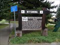
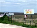 view gallery view galleryNE56.6 km |  Wyoming - South Dakota on Rt. 18 Wyoming - South Dakota on Rt. 18
in Border Crossings Open range area on the Great Plains. The southeast corner of this intersection is also a boundary in SD for the Buffalo Gap National Grassland. posted by: Algoma! location: South Dakota date approved: 06/04/2009 last visited: 09/30/2016 |
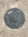
 view gallery view galleryNW57.1 km | BILL NO 1 - Converse County, Wyoming in U.S. Benchmarks Reference mark 1 for USGS benchmark BILL (OU0415). posted by: Tom.dog location: Wyoming date approved: 01/08/2023 last visited: never |
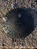
 view gallery view galleryNW57.1 km | BILL (OU0415) - Converse County, Wyoming in U.S. Benchmarks This USGS benchmark is located at the top of a rise adjacent to State Highway 59, about 2.9 miles to the northwest of the beautiful "blink-and-you'll-miss-it" town of Bill, Wyoming. posted by: Tom.dog location: Wyoming date approved: 01/08/2023 last visited: never |
 view gallery view galleryNW57.1 km | BILL NO 2 - Converse County, Wyoming in U.S. Benchmarks Reference mark 2 for USGS benchmark BILL (OU0415). posted by: Tom.dog location: Wyoming date approved: 01/08/2023 last visited: never |
 view gallery view galleryNW58.3 km | J 57 (OU0221) - Converse County, Wyoming in U.S. Benchmarks A benchmark on the north side of USFS Road 961 a short distance west of WY State Highway 59. posted by: Tom.dog location: Wyoming date approved: 10/21/2022 last visited: never |
|