 view gallery view gallery NW10.5 km NW10.5 km
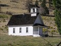
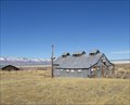
|   Harris School, Summer Lake, OR, USA Harris School, Summer Lake, OR, USA
in Former Schools Picturesque one-room school which served the Summer Lake area. posted by:  Volcanoguy Volcanoguy location: Oregon date approved: 10/02/2007 last visited: 10/02/2007 |
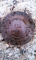
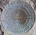
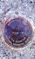
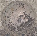
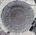 view gallery view galleryNW11.1 km |  NY0186 - USCGS T72, OR NY0186 - USCGS T72, OR
in U.S. Benchmarks U.S. Coast & Geodetic Survey bench mark T72. posted by: Volcanoguy location: Oregon date approved: 09/30/2007 last visited: 09/30/2007 |
 view gallery view gallery N12.2 km N12.2 km
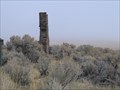
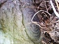
|  Lonely Chimney near Summer Lake, Oregon Lonely Chimney near Summer Lake, Oregon
in Lonely Chimneys Lonely chimney somewhere along Highway 31 in Oregon posted by:  fishingwishing fishingwishing location: Oregon date approved: 12/29/2008 last visited: never |
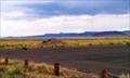
 view gallery view galleryN14.3 km |  Outback Scenic Byway - Jack Lake Interpretive Site Outback Scenic Byway - Jack Lake Interpretive Site
in National Scenic Byways Scenic Byway Interpretive Site at the Jack Lake. posted by: Volcanoguy location: Oregon date approved: 05/25/2008 last visited: 05/25/2008 |
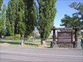
 view gallery view galleryN14.3 km |  Harris Schoolhouse Harris Schoolhouse
in Oregon Historical Markers Two of the six signs at this location. posted by: Volcanoguy location: Oregon date approved: 10/01/2007 last visited: 10/01/2007 |
 view gallery view gallery SE14.3 km SE14.3 km
|  Summer Lake Hot Springs - Summer Lake, OR Summer Lake Hot Springs - Summer Lake, OR
in Hot Springs Hot springs in an old 'cowboy bathhouse'... posted by: fishingwishing location: Oregon date approved: 03/12/2008 last visited: 06/07/2021 |
 view gallery view gallerySE15.4 km | NY0198 - USCGS 'J 72' BM - Lake County, OR in U.S. Benchmarks This NGS benchmark is located just off Hwy 31 in Lake County, OR. posted by: NW_history_buff location: Oregon date approved: 08/31/2013 last visited: never |
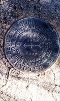
 view gallery view gallerySE15.4 km | NY0985 - NGS 'WORLOW RESET' Horizontal Control Mark - Lake County, OR in U.S. Benchmarks This NGS control mark is located just north of Hwy 31 in Lake County, OR. posted by: NW_history_buff location: Oregon date approved: 09/03/2013 last visited: never |
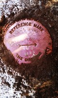
 view gallery view gallerySE15.4 km | CD8886 - NGS Reference Mark 1 - Lake County, OR in U.S. Benchmarks This NGS reference mark is located just north of Hwy 31 in Lake County, OR. posted by: NW_history_buff location: Oregon date approved: 09/03/2013 last visited: never |
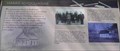
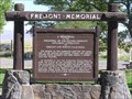 view gallery view galleryN15.9 km | Fremont Memorial in Oregon Historical Markers The Fremont Memorial at Summer Lake posted by: Volcanoguy location: Oregon date approved: 10/01/2007 last visited: 10/01/2007 |
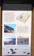 view gallery view galleryN15.9 km | Broken Bedrock in Oregon Historical Markers Two of the four signs at this kiosk at the Summer Lake Rest Area. posted by: Volcanoguy location: Oregon date approved: 10/01/2007 last visited: 10/01/2007 |
 view gallery view galleryN15.9 km | Outback Scenic Byway - Summer Lake Interpretive Site in National Scenic Byways Scenic Byway Interpretive Kiosk at the Summer Lake Rest Area. posted by: Volcanoguy location: Oregon date approved: 05/25/2008 last visited: 05/25/2008 |
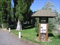
 view gallery view galleryN16.1 km |  Summer Lake Rest Area, Oregon Summer Lake Rest Area, Oregon
in Highway Rest Areas The Summer Lake Rest Area on Ore. Hwy. 31. posted by: Volcanoguy location: Oregon date approved: 10/01/2007 last visited: 10/01/2007 |
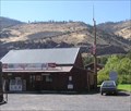 view gallery view galleryN16.1 km |  Summer Lake, OR, 97640 Summer Lake, OR, 97640
in U.S. Post Offices The Summer Lake, OR Post Office. posted by: Volcanoguy location: Oregon date approved: 09/29/2007 last visited: 09/29/2007 |
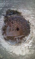
 view gallery view galleryN20.3 km | PB0599 - USCGS W72, OR in U.S. Benchmarks U.S. Coast & Geodetic Survey bench mark W72. posted by: Volcanoguy location: Oregon date approved: 09/30/2007 last visited: 09/30/2007 |
 view gallery view gallerySE20.3 km |  Paisley State Airport - Paisley, OR Paisley State Airport - Paisley, OR
in Airports The Paisley State Airport is located a couple of miles NW of Paisley, OR. posted by: NW_history_buff location: Oregon date approved: 09/20/2013 last visited: 06/07/2021 |
 view gallery view gallerySE21.6 km | NY0200 - Reference Mark 4 - Lake County, OR in U.S. Benchmarks This NGS Reference Mark is located just west of the junction of Hwy 31 and Red House Rd in Lake County, OR. posted by: NW_history_buff location: Oregon date approved: 08/27/2013 last visited: never |
 view gallery view gallerySE21.6 km | NY0200 - Reference Mark 5 - Lake County, OR in U.S. Benchmarks This NGS Reference Mark is located just west of the junction of Hwy 31 and Red House Rd in Lake County, OR. posted by: NW_history_buff location: Oregon date approved: 08/27/2013 last visited: never |
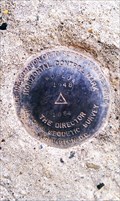
 view gallery view gallerySE21.7 km |  NY0200 - USCGS Azimuth Mark - Lake County, OR NY0200 - USCGS Azimuth Mark - Lake County, OR
in Azimuth Benchmarks This NGS mark is located just north of Red House Rd in Lake County, OR. posted by: NW_history_buff location: Oregon date approved: 08/30/2013 last visited: never |
 view gallery view gallerySE21.7 km | NY0200 - USCGS Azimuth Mark - Lake County, OR in U.S. Benchmarks This NGS mark is located just north of Red House Rd in Lake County, OR. posted by: NW_history_buff location: Oregon date approved: 08/27/2013 last visited: never |
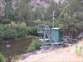 view gallery view gallerySE21.9 km |  Chewaucan River near Paisley, OR, 97758 Chewaucan River near Paisley, OR, 97758
in River Gauges USGS River Gauge on Chewaucan River above Paisley. posted by: Volcanoguy location: Oregon date approved: 10/15/2007 last visited: 10/15/2007 |
 view gallery view gallerySE21.9 km |  Barn Mural, Paisley, Oregon Barn Mural, Paisley, Oregon
in Murals Mural on barn building south of Mill Street. posted by: Volcanoguy location: Oregon date approved: 10/14/2007 last visited: 10/14/2007 |
 view gallery view gallerySE22.2 km | OSHD Blank Paisley, OR in U.S. Benchmarks Blank Oregon State Highway Department benchmark in Paisley. posted by: Volcanoguy location: Oregon date approved: 10/02/2007 last visited: 03/03/2013 |
 view gallery view gallerySE22.4 km | OSHD Z 694 - Paisley, OR in U.S. Benchmarks This benchmark is located at the Chewaucan Bridge in Paisley, OR. posted by: NW_history_buff location: Oregon date approved: 09/12/2012 last visited: never |
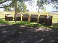
 view gallery view gallerySE22.5 km |  GOOD FOOD Tree - Paisley, OR GOOD FOOD Tree - Paisley, OR
in Omnivorous Trees This omnivorous tree is located in front of the Homestead Restaurant and Mercantile Store in downtown Paisley, OR. posted by: NW_history_buff location: Oregon date approved: 09/14/2012 last visited: never |
|