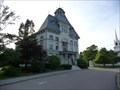
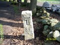
 view gallery view gallery S0.2 km S0.2 km
|   Topsfield, MA Topsfield, MA
in City and Town Halls Located at 8 West Common Street, Topsfield, MA? posted by:  nomadwillie nomadwillie location: Massachusetts date approved: 06/18/2010 last visited: 04/21/2011 |
 view gallery view galleryS0.2 km |  Town Hall Clock - Topfield MA Town Hall Clock - Topfield MA
in Town Clocks 8 West Common Street, Topsfield, MA? posted by: nomadwillie location: Massachusetts date approved: 06/16/2010 last visited: 05/30/2010 |
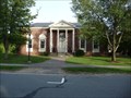 view gallery view galleryS0.2 km |  Topsfield Public Library - Topsfield MA Topsfield Public Library - Topsfield MA
in Libraries Located at 1 S Common St, Topsfield, MA? posted by: nomadwillie location: Massachusetts date approved: 06/16/2010 last visited: 04/21/2011 |
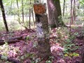
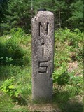 view gallery view gallery NW0.8 km NW0.8 km
|  Danvers-Newburyport railroad, B25N15 Danvers-Newburyport railroad, B25N15
in Milestones A concrete post indicating 25 miles to Boston and 15 miles to Newburyport on the abandon RR route. The rails and sleepers are long gone, and an electric power line now uses the right-of-way. posted by:  bctrail bctrail location: Massachusetts date approved: 06/18/2011 last visited: never |
 view gallery view galleryS1.4 km |  Oldest - Agricultural Fair in America Oldest - Agricultural Fair in America
in First of its Kind The Topsfield Fair, America's oldest agricultural fair, was first established in 1818 as a means to exchange agricultrural ideas and had its first demonstrations and competitions in 1820. posted by: NorStar location: Massachusetts date approved: 10/15/2008 last visited: 10/04/2008 |
 view gallery view galleryS1.4 km |  Topsfield Fairgrounds, Topsfield, MA Topsfield Fairgrounds, Topsfield, MA
in Agricultural Fairgrounds The Topsfield fairgrounds has been the permanent location of the Topsfield Fair, a county-type fair, since 1910. posted by: NorStar location: Massachusetts date approved: 10/12/2008 last visited: 04/21/2011 |
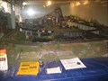 view gallery view galleryS1.6 km |  O-Scale Layout - Grange Building, Topsfield Fair, Topsfield, MA O-Scale Layout - Grange Building, Topsfield Fair, Topsfield, MA
in Model Railroads This train layout is located in a corner of the Grange Farm and Fair Museum in Topsfield, MA. posted by: NorStar location: Massachusetts date approved: 10/13/2008 last visited: 10/04/2008 |
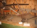 view gallery view galleryS1.6 km |  Agricultural Equip. at Grange Farm and Fair Museum, Topsfield, MA Agricultural Equip. at Grange Farm and Fair Museum, Topsfield, MA
in Old Agricultural Equipment The exhibits at the Grange Farm and Fair Museum in Topsfield, MA, has an assortment of farm equipment, tools and carriages inside an exhibition building. posted by: NorStar location: Massachusetts date approved: 10/13/2008 last visited: never |
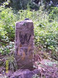
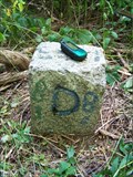
 view gallery view gallery W2.1 km W2.1 km
|  Boxford-Topsfield 3 (B-T3) Boxford-Topsfield 3 (B-T3)
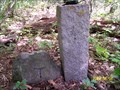
in Public Land Survey Marks A granite post marking one point on the boundary line between the towns of Boxford and Topsfield, Massachusetts. It is located on Lockwood Lane, near the I-95 overpass. posted by: bctrail location: Massachusetts date approved: 06/29/2009 last visited: never |
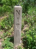 view gallery view gallery SE2.3 km SE2.3 km
| Danvers-Newburyport railroad, B23N17 in Milestones A concrete post indicating 23 miles to Boston and 17 miles to Newburyport on the abandon RR route. The rails and most of the sleepers have been removed, and an electric power line now uses the right-of-way. posted by: bctrail location: Massachusetts date approved: 06/19/2011 last visited: never |
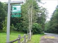
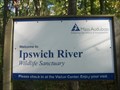 view gallery view gallerySE2.3 km |  Mass Audubon Ipswich River Wildlife Sanctuary Mass Audubon Ipswich River Wildlife Sanctuary
in Public Access Lands At 2,265 acres, Mass Audubon's largest sanctuary contains ten miles of trails and eight miles of canoeing on the Ipswich River. Seventy percent of the acreage is wetlands. posted by: bctrail location: Massachusetts date approved: 10/09/2010 last visited: 10/17/2011 |
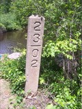 view gallery view gallerySE2.6 km | Danvers-Newburyport railroad, B23.02 in Milestones A concrete post indicating 23.02 miles from the Ipswich River bridge to Boston on the abandon RR route. The rails and sleepers have been removed, and an electric power line now uses the right-of-way. posted by: bctrail location: Massachusetts date approved: 06/19/2011 last visited: 01/19/2013 |
 view gallery view gallery E2.6 km E2.6 km
|  Boardwalks, Ipswich River Wildlife Sanctuary, Massachusetts Audubon - Topsfield, MA Boardwalks, Ipswich River Wildlife Sanctuary, Massachusetts Audubon - Topsfield, MA
in Non-Coastal Boardwalks This sanctuary, part of the network of sanctuaries run by Massachusetts Audubon, has several boardwalks posted by: NorStar location: Massachusetts date approved: 03/19/2017 last visited: never |
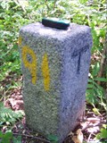
 view gallery view gallery SW2.9 km SW2.9 km
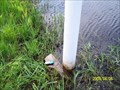
|  MY6025: 4849 (MAGS/NGS, Boxford, MA) MY6025: 4849 (MAGS/NGS, Boxford, MA)
in U.S. Benchmarks A MAGS standard disk, located in Boxford, MA.
The NGS PID# is MY6025.
The MHD ID# is 3361. posted by: NH2beers location: Massachusetts date approved: 06/30/2011 last visited: never |
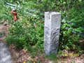
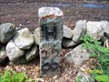
 view gallery view gallerySE3.1 km |  Topsfield-Wenham 2 (T-W2) Topsfield-Wenham 2 (T-W2)
in U.S. Historic Survey Stones and Monuments A granite post marking one point on the boundary line between the towns of Topsfield and Wenham, Essex County, Massachusetts. It is located in the Massachusetts Audubon Ipswich River Wildlife Sanctuary, on Perkins Island. posted by: bctrail location: Massachusetts date approved: 08/09/2009 last visited: never |
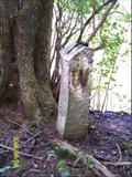 view gallery view gallerySE3.1 km | Topsfield-Wenham 1 WM (T-W1 WM) in U.S. Historic Survey Stones and Monuments A granite post marking one point on the boundary line between the towns of Topsfield and Wenham, Essex County, Massachusetts. It is located in the Massachusetts Audubon Ipswich River Wildlife Sanctuary. It is on the north end of Perkins Island. posted by: bctrail location: Massachusetts date approved: 08/10/2009 last visited: never |
 view gallery view gallerySE3.2 km | Topsfield-Wenham 3 (T-W3) in U.S. Historic Survey Stones and Monuments A granite post marking one point on the boundary line between the towns of Topsfield and Wenham, Essex County, Massachusetts. It is on the Salem-Beverly Waterway Canal. posted by: bctrail location: Massachusetts date approved: 08/06/2009 last visited: 01/19/2013 |
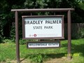 view gallery view galleryE3.4 km |  Bradley Palmer State Park, Topsfield and Hamilton, MA Bradley Palmer State Park, Topsfield and Hamilton, MA
in State/Provincial Parks This 721-acre former estate provides recreation for adults and kids of all ages. It features miles of serene forest trails, acres of meadows and spectacular rhododendrons. posted by: bctrail location: Massachusetts date approved: 07/07/2009 last visited: 08/30/2016 |
 view gallery view gallerySE3.4 km | Topsfield-Wenham 4 (T-W4) in U.S. Historic Survey Stones and Monuments A granite post marking one point on the boundary line between the towns of Topsfield and Wenham, Essex County, Massachusetts. It is near the old RR bed. posted by: bctrail location: Massachusetts date approved: 08/06/2009 last visited: 01/19/2013 |
 view gallery view gallerySE3.7 km | Danvers-Topsfield 2 (D-T2) in U.S. Historic Survey Stones and Monuments A granite post marking one point on the boundary line between the Towns of Danvers and Topsfield, Massachusetts. posted by: bctrail location: Massachusetts date approved: 07/06/2010 last visited: never |
 view gallery view galleryE3.7 km | Hamilton-Topsfield 11 (H-T11) in Public Land Survey Marks A granite post marking one point on the boundary line between the towns of Hamilton and Topsfield, Massachusetts. posted by: bctrail location: Massachusetts date approved: 07/05/2009 last visited: never |
 view gallery view gallerySE3.7 km | Danvers-Topsfield-Wenham (D-T-W) in U.S. Historic Survey Stones and Monuments A granite post marking the three way junction point of the boundary lines between the towns of Danvers, Topsfield, and Wenham, Essex County, Massachusetts.It is at the intersection of Routes 35 and 97. posted by: bctrail location: Massachusetts date approved: 07/06/2010 last visited: never |
 view gallery view galleryE3.9 km | Hamilton-Topsfield #02 (HT-02) in Public Land Survey Marks A granite post marking one point on the boundary line between the towns of Hamilton and Topsfield, Massachusetts. It is located in Bradley Palmer State Park. posted by: bctrail location: Massachusetts date approved: 06/29/2009 last visited: never |
 view gallery view gallery NE3.9 km NE3.9 km
| Willowdale Meadow in Public Access Lands Located in Topsfield, Massachusetts, and surrounded by Willowdale State Forest, this 8.7 acre parcel, now conserved, was the last remaining buildable parcel in the area. posted by: bctrail location: Massachusetts date approved: 07/17/2009 last visited: 08/30/2016 |
 view gallery view galleryE3.9 km | Hamilton-Topsfield #10A (HT-10A) in Public Land Survey Marks A granite post marking one point on the boundary line between the towns of Hamilton and Topsfield, Massachusetts. It is located on Asbury Street. posted by: bctrail location: Massachusetts date approved: 06/30/2009 last visited: never |
|