 view gallery view gallery NE1.6 km NE1.6 km
|   Deer Island, Southern End - Boston, MA Deer Island, Southern End - Boston, MA
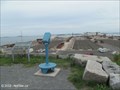
in Coin-Op Binoculars This is quite possibly the best mainland view of the Boston Harbor Islands and the Atlantic Ocean with binoculars. posted by:  NorStar NorStar location: Massachusetts date approved: 09/04/2012 last visited: never |
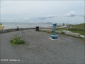
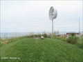
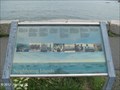 view gallery view galleryNE1.6 km |  Boston Harbor Islands Orientation Table, Deer Island South Point - Boston, MA Boston Harbor Islands Orientation Table, Deer Island South Point - Boston, MA
in Orientation Tables This table is located at the southern point of Deer Island where there is a commanding panoramic view of the Boston Harbor Islands. posted by: NorStar location: Massachusetts date approved: 09/08/2012 last visited: never |
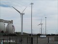 view gallery view galleryNE1.8 km |  Trio of Wind Turbines at Deer Island - Boston, MA Trio of Wind Turbines at Deer Island - Boston, MA
in Windmills The three wind turbines are part of an effort by the Deer Island Sewage Treatment facility to generate as much of their own electricity as they can to run the operations. posted by: NorStar location: Massachusetts date approved: 08/29/2012 last visited: never |
 view gallery view gallery N1.8 km N1.8 km
|  You Are Here - Deer Island, By Ferry Dock - Boston, MA You Are Here - Deer Island, By Ferry Dock - Boston, MA
in 'You Are Here' Maps This fading sign is located by the passenger ferry dock for Deer Island, where you can walk around the sewage treatment center with spectacular views of the city and ocean. posted by: NorStar location: Massachusetts date approved: 09/01/2012 last visited: never |
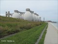
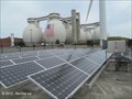 view gallery view galleryN1.8 km |  Deer Island Sewage Treatment Facility - Boston, MA Deer Island Sewage Treatment Facility - Boston, MA
in Solar Power There are 736 kwatts worth of solar voltaic arrays that, with the wind and other sources, reduce the electricity demands made by this sewage treatment facility on the grid. posted by: NorStar location: Massachusetts date approved: 09/06/2012 last visited: never |
 view gallery view galleryN1.8 km |  The Deer Island Sewage Treatment Plant - Boston, MA The Deer Island Sewage Treatment Plant - Boston, MA
in Wastewater Treatment Facilities The Deer Island Sewage Treatment Plant, the capstone of a project to clean up Boston Harbor and improve the waterworks infrastructure and run by the MWRA, handles sewage from 43 communities that are part of the Greater Boston Metropolitan area. posted by: NorStar location: Massachusetts date approved: 09/02/2012 last visited: 09/15/2013 |
 view gallery view gallery SW1.9 km SW1.9 km
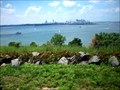
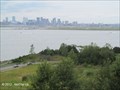
|  Spectacle Island, MA - Overlooking Boston Harbor and the City of Boston Spectacle Island, MA - Overlooking Boston Harbor and the City of Boston
in Scenic Overlooks Spectacle Island is one of the Boston Harbor Islands. It offers wonderful panoramic views of Boston Harbor and the City of Boston. posted by:  neoc1 neoc1 location: Massachusetts date approved: 06/03/2011 last visited: 09/13/2014 |
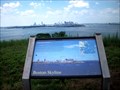
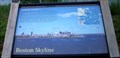 view gallery view gallerySW1.9 km | Spectacle Island Orientation Table of the Boston Skyline - Boston, MA in Orientation Tables Spectacle Island is one of the Boston Harbor Islands. It offers wonderful panoramic views of Boston Harbor and the City of Boston. posted by: neoc1 location: Massachusetts date approved: 07/05/2011 last visited: never |
 view gallery view gallerySW1.9 km |  Boston, MA - Cityscape from Spectacle Island Boston, MA - Cityscape from Spectacle Island
in Cityscapes Cityscape of Boston from the high point on Spectacle Island. posted by: neoc1 location: Massachusetts date approved: 06/02/2011 last visited: 09/13/2014 |
 view gallery view gallerySW2.1 km |  Spectacle Island - Boston Harbor Islands, MA Spectacle Island - Boston Harbor Islands, MA
in State Park Passport Locations Spectacle Island is a pair of drumlins connected by a spit of land in Boston Harbor. posted by: neoc1 location: Massachusetts date approved: 06/01/2011 last visited: 09/15/2013 |
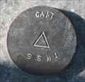 view gallery view gallerySW2.1 km |  CA/T SSW1 CA/T SSW1
in U.S. Benchmarks Central Artery/Tunnel mark SSW1. posted by:  Shorelander Shorelander location: Massachusetts date approved: 09/06/2007 last visited: 09/09/2017 |
 view gallery view gallerySW2.3 km | CA/T SSW2 - Spectacle Island, Boston Harbor, MA in U.S. Benchmarks CA/T Marker on Seawall, stamped SSW2, south of visitor center, Spectacle Island posted by: bebkm location: Massachusetts date approved: 07/10/2006 last visited: 09/09/2017 |
 view gallery view galleryN2.4 km | Boston and Logan Airport from Deer Island Drumlin - Boston, MA in Cityscapes Spectacular views of Boston and Logan International Airport are available from the top of a drumlin at Deer Island. posted by: NorStar location: Massachusetts date approved: 09/06/2012 last visited: never |
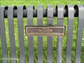 view gallery view galleryN2.4 km |  Joe Griffith Bench at Deer Island - Boston, MA Joe Griffith Bench at Deer Island - Boston, MA
in Dedicated Benches This bench is dedicated by the people from his company to Joe Griffith, "A World Class Tunneler." posted by: NorStar location: Massachusetts date approved: 08/29/2012 last visited: never |
 view gallery view galleryN2.4 km | Binoculars, Deer Island Drumlin - Boston, MA in Coin-Op Binoculars How much would you pay to have a binocular view of one of the largest sewage treatment plants in the country? A dollar? Fifty cents?...Free? posted by: NorStar location: Massachusetts date approved: 09/04/2012 last visited: never |
 view gallery view galleryN2.4 km |  New Rest Haven Cemetery, Deer Island - Boston, MA New Rest Haven Cemetery, Deer Island - Boston, MA
in Worldwide Cemeteries The New Rest Haven Cemetery is located on a drumlin overlooking Deer Island and is where graves of people from the prison, school and hospital previously located on Deer Island were relocated. posted by: NorStar location: Massachusetts date approved: 09/04/2012 last visited: never |
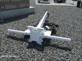 view gallery view galleryN2.4 km |  Anchor, Deer Island National Park and Recreational Area - Boston, MA Anchor, Deer Island National Park and Recreational Area - Boston, MA
in Anchors This anchor is located at the entrance to Deer Island, both a huge sewage treatment facility and a part of the Boston Harbor Islands National Park and Recreation Area (really!). posted by: NorStar location: Massachusetts date approved: 08/28/2012 last visited: 10/12/2012 |
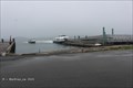 view gallery view gallery SE3.4 km SE3.4 km
|  Boston Harbor Islands Ferry Dock at Georges Island - Boston, MA Boston Harbor Islands Ferry Dock at Georges Island - Boston, MA
in Ferries and Ferry Landings This dock is where the Boston Harbor Islands Ferry (and other boats) land, and serves as a hub to ferries and taxis to the other Boston Harbor Islands. posted by: NorStar location: Massachusetts date approved: 09/16/2015 last visited: 05/16/2022 |
 view gallery view gallerySE3.4 km |  Visitor Center - Georges Island - Boston, MA Visitor Center - Georges Island - Boston, MA
in History Museums The Visitor Center contains signs and artifact displays of the history of Georges Island. posted by: NorStar location: Massachusetts date approved: 09/18/2015 last visited: 05/16/2022 |
 view gallery view gallery E3.4 km E3.4 km
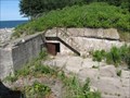
|  Fort Standish Fort Standish
in World War II Sites A WWII coastal defense fortification in Boston Harbor, Massachusetts. posted by: Shorelander location: Massachusetts date approved: 09/21/2007 last visited: 09/15/2013 |
 view gallery view gallerySE3.4 km |  Escape! - Fort Warren - Georges Island - Boston, MA Escape! - Fort Warren - Georges Island - Boston, MA
in Massachusetts Historical Markers Ft. Warren, used during the Civil War as a prison for Confederate soldiers, politicians and Union deserters, was a secure facility with changeable currents in the channels and often stormy weather. posted by: NorStar location: Massachusetts date approved: 10/21/2015 last visited: 09/28/2022 |
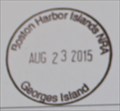 view gallery view gallerySE3.4 km |  Boston Harbor Islands Recreation Area - Georges Island - Boston, MA Boston Harbor Islands Recreation Area - Georges Island - Boston, MA
in NPS Passport Cancellation Stations The stamp is located within the brick building on the island that houses exhibits about the island. posted by: NorStar location: Massachusetts date approved: 03/07/2016 last visited: 05/16/2022 |
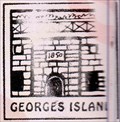 view gallery view gallerySE3.4 km | Georges Island - Boston Harbor Islands, MA in State Park Passport Locations Georges Island is the site of historic Fort Warren posted by: neoc1 location: Massachusetts date approved: 06/03/2011 last visited: 09/15/2013 |
 view gallery view gallerySE3.4 km | MY0014 - TIDAL 7 STA 32 - Boston, MA in U.S. Benchmarks The survey disk TIDAL 7 STA 32 is set on the wall of a brick building that currently holds exhibits about Georges Island and Boston Harbor. posted by: NorStar location: Massachusetts date approved: 08/30/2015 last visited: 08/27/2016 |
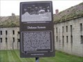 view gallery view gallerySE3.4 km |  Defense System (Fort Warren)-Georges Island, MA Defense System (Fort Warren)-Georges Island, MA
in Signs of History From this vantage point it is possible to see the principal elements of Ft. Warren’s defense system. These are based on the 17th century, military theories developed by Louis XIV’s chief engineer, Sebastien de Vauban. posted by: Don.Morfe location: Massachusetts date approved: 11/29/2019 last visited: 09/28/2021 |
|