 view gallery view gallery SW1.4 km SW1.4 km
|   Crystal Spring Crystal Spring
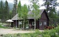
in Spring Houses A wooden spring house in Allenspark. posted by:  Jeremy Jeremy location: Colorado date approved: 09/22/2005 last visited: never |
 view gallery view gallery W4.5 km W4.5 km
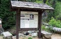
|  Wild Basin, Rocky Mountain National Park - Rocky Mountains National Park, CO Wild Basin, Rocky Mountain National Park - Rocky Mountains National Park, CO
in Wikipedia Entries Wild Basin is a scenic area in the southeastern part of Rocky Mountains National Park. The area is known for the creeks, waterfalls and wildflowers. posted by:  hummerstation hummerstation location: Colorado date approved: 11/06/2014 last visited: never |
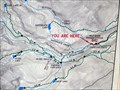 view gallery view galleryW4.5 km |  You Are Here - Wild Basin - Rocky Mountains National Park You Are Here - Wild Basin - Rocky Mountains National Park
in 'You Are Here' Maps You Are Here map to provide orientation to the many trails in the Wild Basin area. posted by: hummerstation location: Colorado date approved: 07/25/2014 last visited: never |
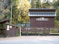
 view gallery view galleryW4.5 km |  Wild Basin Ranger Station - Rocky Mountains National Park, CO Wild Basin Ranger Station - Rocky Mountains National Park, CO
in Ranger Stations Wild Basin Ranger Station provides information about Wild Basin and Rocky Mountain National Park, back-country permits, and offices for the law enforcement rangers. posted by: hummerstation location: Colorado date approved: 11/11/2014 last visited: never |
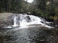 view gallery view galleryW5 km |  Copeland Falls, Rocky Mountain National Park Copeland Falls, Rocky Mountain National Park
in Waterfalls Less than 1/2 mile from the Wild Basin Trailhead in Rocky Mountain National Park, St. Vrain Creek cascades down the canyon through Upper and Lower Copeland Falls. Coordinates are just below Upper Copeland Falls. Photos taken 23 August 2012. posted by: EvilWickedMochaScout location: Colorado date approved: 08/24/2012 last visited: never |
 view gallery view gallery N5.3 km N5.3 km
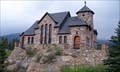
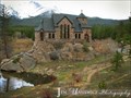
| Chapel on the Rock - Allenspark, CO in Wikipedia Entries The Chapel on the Rock was built in 1935 by Monsignor Joseph Bosetti with the intention of utilizing the symbolism of the strength of the rock that the chapel sits on. posted by: hummerstation location: Colorado date approved: 12/24/2014 last visited: never |
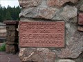 view gallery view galleryN5.3 km |  MCMXXXV (1935) - Saint Catherine of Siena Chapel - Allenspark, CO MCMXXXV (1935) - Saint Catherine of Siena Chapel - Allenspark, CO
in Dated Buildings and Cornerstones The Chapel on the Rock was built in 1935 by Monsignor Joseph Bosetti with the intention of utilizing the symbolism of the strength of the rock that the chapel sits on. posted by: hummerstation location: Colorado date approved: 12/24/2014 last visited: never |
 view gallery view galleryN5.3 km |  Saint Malo - Chapel on the Rock - Allenspark, CO Saint Malo - Chapel on the Rock - Allenspark, CO
in Roman Catholic Churches The Chapel on the Rock (officially, Saint Catherine of Siena's Chapel) is a popular tourist landmark in Allenspark, Colorado visited by thousands every year. posted by: ArmyFamily4 location: Colorado date approved: 04/17/2011 last visited: 06/07/2014 |
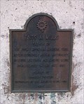 view gallery view galleryN9 km |  Enos A. Mills - Rocky Mountains National Park, CO Enos A. Mills - Rocky Mountains National Park, CO
in Colorado Historical Markers The Enos A. Mills historical marker overlooks the area homesteaded by Mr. Mills. posted by: hummerstation location: Colorado date approved: 11/08/2014 last visited: never |
 view gallery view galleryN9 km |  Enos A. Mills - Estes Park, CO Enos A. Mills - Estes Park, CO
in Citizen Memorials The Enos A. Mills memorial overlooks the area homesteaded by Mr. Mills. posted by: hummerstation location: Colorado date approved: 11/10/2014 last visited: never |
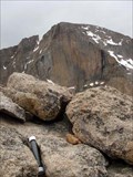
 view gallery view galleryN9.7 km |  Twin Sisters Peak - North Summit Register Twin Sisters Peak - North Summit Register
in Summit Registers Summit Register at the Northern of the two Twin Sisters Summit. posted by: Team Laxson location: Colorado date approved: 10/21/2008 last visited: never |
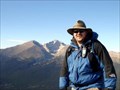
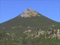
 view gallery view galleryN9.7 km |  Twin Sisters Twin Sisters
in Mountain Summits Fantastic views of other mountains as well as the flatlands. posted by:  Flying Cacher Flying Cacher location: Colorado date approved: 07/18/2006 last visited: 06/03/2011 |
 view gallery view gallery NW9.7 km NW9.7 km
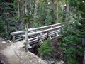
|  Longs Peak Trail Footbridge/Waterfall Crossing Longs Peak Trail Footbridge/Waterfall Crossing
in Hiking Path Footbridges A nice wooden footbridge along the Longs Peak Trail. The bridge is 2.2 miles from the trailhead. posted by: Team Laxson location: Colorado date approved: 07/25/2009 last visited: 08/11/2011 |
 view gallery view gallery SE10.1 km SE10.1 km
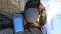
|  T2NR72W - Roosevelt National Forest Boundary Marker T2NR72W - Roosevelt National Forest Boundary Marker
in U.S. Benchmarks Located on border of Roosevelt National Forest and Overland Drive (Private Road). posted by: huggy_d1 location: Colorado date approved: 11/08/2009 last visited: never |
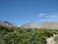
 view gallery view galleryNW10.5 km |  Longs Peak Trail Longs Peak Trail
in Scenic Hikes The Longs Peak trail will take you through a variety of landscapes, from Forests, meadows, boulders, and those who brave it, the summit of Longs Peak. posted by: Team Laxson location: Colorado date approved: 07/21/2010 last visited: 10/10/1999 |
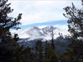
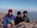
 view gallery view galleryNW10.5 km | Longs Peak Summit Register (14,259) in Summit Registers Longs Peak is the highest mountain in the Rocky Mountain National Park, and dominates the skyline for much of Norther Colorado.
This summit register rests 14,259 above sea level. posted by: Team Laxson location: Colorado date approved: 07/21/2010 last visited: 10/02/1988 |
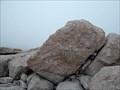
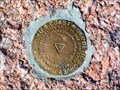 view gallery view galleryNW10.5 km | LONGS PEAK (LL1346) - Boulder County, Colorado in U.S. Benchmarks A triangulation station on the summit of Longs Peak. posted by: Tom.dog location: Colorado date approved: 11/28/2022 last visited: never |
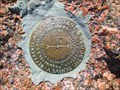 view gallery view galleryNW10.5 km | LONGS PEAK NO 1 - Boulder County, Colorado in U.S. Benchmarks Reference mark 1 for triangulation station LONGS PEAK. posted by: Tom.dog location: Colorado date approved: 11/28/2022 last visited: never |
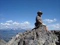
 view gallery view galleryNW10.5 km | Longs Peak in Mountain Summits It was a long hike, but rewarding one. posted by: TeamJLB location: Colorado date approved: 11/20/2005 last visited: 03/15/2020 |
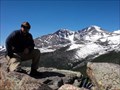
 view gallery view galleryNW10.5 km | Mt. Lady Washington (13,281) in Mountain Summits A grueling 13 mile (roundtrip) hike up to quite possibly the best view of Long's Peak in Colorado. posted by: Team Laxson location: Colorado date approved: 07/20/2009 last visited: never |
 view gallery view galleryNW10.5 km | Mt. Lady Washington (13,281) in Scenic Hikes A beautiful hike in Colorado's high country, the hike to the summit of Mt. Lady Washington will offer you the best view of Longs Peak in Colorado, waterfall crossings, a forest of trees, wildlife, wildflowers, and a wide variety of other posted by: Team Laxson location: Colorado date approved: 07/25/2009 last visited: never |
 view gallery view galleryNW10.5 km | Mt. Lady Washington Summit Register (13,281) in Summit Registers The summit register for Mt. Lady Washington is located at 13,281 feet above sea level, and offers those who conquer this mountain one of the best views of Longs Peak in Colorado. posted by: Team Laxson location: Colorado date approved: 07/25/2009 last visited: never |
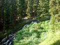
 view gallery view galleryN11.3 km | Bridge over Alpine Brook via Storm Pass in Hiking Path Footbridges This footbridge takes you over Alpine Brook, a brook fed by melting snow from Colorado mountains. posted by: Team Laxson location: Colorado date approved: 07/06/2010 last visited: never |
 view gallery view galleryNW11.3 km | Estes Cone (11,007) via Lily Lake Trailhead in Scenic Hikes The hike to Estes Cone from the Lily Lake trailhead will take you over the Alpine Brook, a small waterfall, and give you an opportunity to view the Front Range of Colorado. posted by: Team Laxson location: Colorado date approved: 06/02/2010 last visited: 08/11/2011 |
 view gallery view galleryNW11.3 km | Estes Cone (11,007) / Rocky Mountain National Park in Mountain Summits Estes Cone summits at 11,007ft above sea level, and gives you stunning view of Longs Peak, Meeker, and Twin Sister mountains. posted by: Team Laxson location: Colorado date approved: 07/06/2010 last visited: 06/26/2010 |
|