The summit register for Longs peak lies just below the benchmark on Longs, resting at 14,259 ft above sea level. This one will not be easy to visit as it requires planning, stamina, a little courage, and about 10-14 hours of hiking. For the masses, the best time to hike to the summit is mid-July through early September.
Long's Peak stands proudly as Colorado's northernmost fourteener. It is unquestionably the monarch of the Front Range and northern Colorado. It is not only the highest peak in Rocky Mountain National Park and Boulder County, but it is also the 15th highest peak in Colorado. It's close proximity to Denver and its pure majesty make it the most popular climbing mountain in the state.
Routes up the mountain range from the Class 3 Keyhole to extremely technical, with some routes requiring rappelling gear.

A little History
Longs Peak and its southern neighbor, Mt. Meeker (13,911 ft.), were called
Nesotaieux (The Two Guides) by the Arapaho Indians and were known as
Les Deux Orielles (The Two Ears) by early French fur traders. The mountain takes its name from Major Stephen H. Long (1784-1864), whose expedition made the first recorded sighting of the peak on June 30, 1820.
At least 57 people have died climbing or hiking Longs Peak. According to the National Park Service, one person, on average, dies every year attempting to climb the mountain. At of July 20th, 2010, there have been three confirmed deaths on Longs this year, the most recent occurring just 2 day ago.
Agnes Vaille froze to death at the base of the North Face January 12, 1925. To commemorate her loss, and that of Herbert Sortland who froze to death during a rescue attempt, a stone shelter was constructed near the keyhole.

The Hike
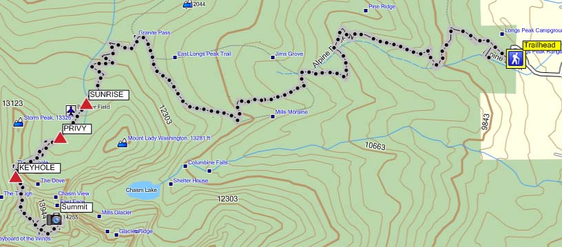
The hike itself is impressive, nearly 15 miles round trip, with just under 1 mile of elevation gain (5,100 ft). Starting elevation at the Longs Peak Ranger station is around 9,400, and the trail is all uphill from there. Along the way, you'll cross the Alpine Brook, hike through the forest, and have the opportunity to see a variety of different wildlife. The high elevations offer perfect perching spots for 280 bird species, including the three-toed woodpecker, pygmy nuthatch, mountain chickadee, brown-capped rosy finch, and pygmy owl.
Trailhead
The trailhead is west of Colorado 7 and can be reached from the north or the south. For the northern approach, drive 9.2 miles south from the intersection of US 36 and CO 7 to the turnoff for the Ranger Station. For the southern approach, drive north 10 miles from the junction of CO 7 and CO 72 on the Peak to Peak Highway to the Ranger Station turnoff. From the turnoff drive west 1 mile to the trailhead.