 view gallery view gallery SW8.4 km SW8.4 km
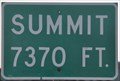
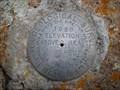
|   Loa Summit ~ Elevation 7370 Feet Loa Summit ~ Elevation 7370 Feet
in Elevation Signs This Elevation Sign is located on the southwest side of Utah Highway 24 northwest of Loa, Utah. posted by:  brwhiz brwhiz location: Utah date approved: 05/20/2013 last visited: 09/02/2022 |
 view gallery view gallery W15.9 km W15.9 km
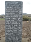
|  In Memory of Known and Unknown - Glenwood, UT, USA In Memory of Known and Unknown - Glenwood, UT, USA
in Graves of the Unknown This Marker for the Known and Unknown is located in the Glenwood Pioneer Cemetery, Glenwood, Utah. posted by:  Chasing Blue Sky Chasing Blue Sky location: Utah date approved: 05/09/2011 last visited: 04/25/2011 |
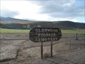 view gallery view galleryW15.9 km |  Glenwood Pioneer Cemetery - Glenwood, UT, USA Glenwood Pioneer Cemetery - Glenwood, UT, USA
in Worldwide Cemeteries A Pioneer Cemetery on the south end of Glenwood, Utah. posted by: Chasing Blue Sky location: Utah date approved: 05/10/2011 last visited: 04/25/2011 |
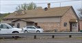
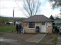 view gallery view galleryW15.9 km |  Glenwood, Utah 84730 Glenwood, Utah 84730
in U.S. Post Offices The local Post Office in the town of Glenwood, Utah. posted by: Chasing Blue Sky location: Utah date approved: 04/30/2011 last visited: 12/17/2011 |
 view gallery view galleryW16.1 km |  Glenwood, UT, USA Glenwood, UT, USA
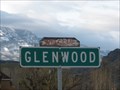
in People-Named Places The Town of Glenwood, Utah is named after Robert Wilson Glenn, an early Pioneer in the area. posted by: Chasing Blue Sky location: Utah date approved: 05/02/2011 last visited: 04/25/2011 |
 view gallery view galleryW16.1 km |  Glenwood, UT, USA Glenwood, UT, USA
in Wikipedia Entries Glenwood, Utah is located in central Utah, in Sevier County. It is located directly east of the county seat in Richfield. posted by: Chasing Blue Sky location: Utah date approved: 12/18/2012 last visited: 04/25/2011 |
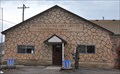
 view gallery view galleryW16.1 km |  Glenwood, UT Glenwood, UT
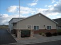
in City and Town Halls The Town Hall of Glenwood, Utah is located at 175 East 300 North. posted by: Chasing Blue Sky location: Utah date approved: 05/01/2011 last visited: 04/25/2011 |
 view gallery view galleryW16.1 km |  ZCMI Co-Op Building - Glenwood, UT ZCMI Co-Op Building - Glenwood, UT
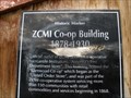
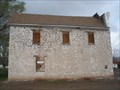
in Utah Historical Markers The ZCMI Co-Op Building is located at 15 West Center Street in Glenwood, Utah. posted by: Chasing Blue Sky location: Utah date approved: 05/01/2011 last visited: 04/25/2011 |
 view gallery view galleryW16.1 km |  Glenwood Cooperative Store - Glenwood, UT Glenwood Cooperative Store - Glenwood, UT
in U.S. National Register of Historic Places The Glenwood Cooperative Store is located at 15 West Center Street in Glenwood, Utah. posted by: Chasing Blue Sky location: Utah date approved: 05/01/2011 last visited: 04/25/2011 |
 view gallery view galleryW16.1 km | Glenwood Cooperative Mercantile - Glenwood, UT in Utah Historical Markers The Glenwood Cooperative Mercantile is located at 15 West Center Street in Glenwood, Utah. posted by: Chasing Blue Sky location: Utah date approved: 05/01/2011 last visited: 04/25/2011 |
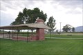
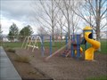 view gallery view galleryW16.1 km |  Glenwood Town Park Playground - Glenwood, UT Glenwood Town Park Playground - Glenwood, UT
in Public Playgrounds The playground at the Town Park in Glenwood, Utah. posted by: Chasing Blue Sky location: Utah date approved: 04/30/2011 last visited: 04/25/2011 |
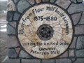 view gallery view galleryW16.4 km |  Peterson Mill Millstone - Glenwood, UT, USA Peterson Mill Millstone - Glenwood, UT, USA
in Millstones This millstone is set into the base of an historical marker for the Glenwood United Order, located at the north end of Glenwood, Utah. posted by: Chasing Blue Sky location: Utah date approved: 12/18/2012 last visited: 09/10/2022 |
 view gallery view galleryW16.4 km |  Glenwood United Order - 77 Glenwood United Order - 77
in D.U.P. Historic Markers A D.U.P. monument at the north end of Glenwood, Utah on Highway 119. posted by: Chasing Blue Sky location: Utah date approved: 04/27/2011 last visited: 11/15/2019 |
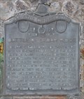
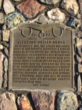 view gallery view galleryW16.4 km | Glenwood United Order in Utah Historical Markers On October 2, 1874, the Latter-day Saints living in this locality organized a modern order of Enoch called the United Order, established under counsel and instruction of Brigham Young. Families placed their land, cattle, sheep...... posted by: JacobBarlow location: Utah date approved: 01/13/2008 last visited: 10/05/2021 |
 view gallery view gallery S16.6 km S16.6 km
|  Fish Lake - JN0377 - Sevier County, UT Fish Lake - JN0377 - Sevier County, UT
in U.S. Benchmarks This Benchmark is at Fish Lake Hightop, which is the high point of Sevier County, Utah. As one would infer, it is in the mountain ridge west of, and overlooking, Fish Lake. posted by: Chasing Blue Sky location: Utah date approved: 10/05/2012 last visited: 09/04/2011 |
 view gallery view galleryS16.6 km |  Fish Lake Hightop - Sevier County, UT Fish Lake Hightop - Sevier County, UT
in Mountain Summits Fish Lake Hightop is the high point in Sevier County, Utah. As one would infer, it is at the top of the mountain ridge west of, and overlooking, Fish Lake. posted by: Chasing Blue Sky location: Utah date approved: 10/06/2012 last visited: 09/04/2011 |
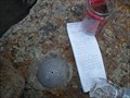 view gallery view galleryS16.6 km |  Fish Lake Hightop Summit Register - Sevier County, UT Fish Lake Hightop Summit Register - Sevier County, UT
in Summit Registers This register is at Fish Lake Hightop, which is the high point in Sevier County, Utah. As one would infer, it is in the mountain ridge west of, and overlooking, Fish Lake. posted by: Chasing Blue Sky location: Utah date approved: 10/18/2012 last visited: 09/04/2011 |
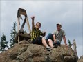 view gallery view galleryS16.6 km |  Fish Lake Hightop - Sevier County, UT Fish Lake Hightop - Sevier County, UT
in Geographic High Points Fish Lake Hightop is the high point in Sevier County, Utah. As one would infer, it is at the top of the mountain ridge west of, and overlooking, Fish Lake. posted by: Chasing Blue Sky location: Utah date approved: 10/07/2012 last visited: 09/04/2011 |
 view gallery view galleryS16.9 km |  You Are Here - Fish Lake Hightop Trailhead - Sevier County, UT You Are Here - Fish Lake Hightop Trailhead - Sevier County, UT
in 'You Are Here' Maps This "You Are Here" map is on the Fish Lake Hightop Trailhead marker along the Fish Lake Hightop Plateau that overlooks Fish Lake, in Sevier County, Utah. posted by: Chasing Blue Sky location: Utah date approved: 10/11/2012 last visited: 09/04/2011 |
 view gallery view gallery NW17.4 km NW17.4 km
| Sigurd, Utah 84657 in U.S. Post Offices The Sigurd Post Office serves about 120 households from its location at 20 S Main Street, at the junction Main Street with Utah Highway 24. posted by: brwhiz location: Utah date approved: 06/10/2011 last visited: 12/17/2011 |
 view gallery view galleryNW17.4 km | Sigurd, Utah in Wikipedia Entries Sigurd is a small agricultural town of about 450 inhabitants located in northeastern Sevier County. posted by: brwhiz location: Utah date approved: 06/11/2011 last visited: never |
 view gallery view galleryNW17.9 km | Battle of Cedar Ridge in Utah Historical Markers On April 5, 1868, a company of 23 men under the leadership of Frederick Olson of Spring City were on their way to Monroe with the intention of resettling that locality. When at Cedar Ridge near Rocky Ford, now within the limits of Vermillion.... posted by: JacobBarlow location: Utah date approved: 01/13/2008 last visited: 01/14/2008 |
 view gallery view galleryNW17.9 km |  Battle of Cedar Ridge Battle of Cedar Ridge
in Battlefields The only remaining evidence of this battlefield is a Daughters of Utah Pioneers historic marker in the immediate vicinity of the place where the battle took place. posted by: brwhiz location: Utah date approved: 11/20/2012 last visited: never |
 view gallery view galleryNW17.9 km | Battle of Cedar Ridge ~ 159 in D.U.P. Historic Markers This Daughters of Utah Pioneers Historical Marker is mounted on a stone monument on the west side of Utah Highway 24, just south of Vermillion, Utah. posted by: brwhiz location: Utah date approved: 11/17/2012 last visited: never |
 view gallery view galleryNW17.9 km |  Town Park ~ Sigurd, Utah Town Park ~ Sigurd, Utah
in Municipal Parks and Plazas This Municipal Park is located at approximately 55 N State Street in Sigurd, Utah. posted by: brwhiz location: Utah date approved: 03/14/2013 last visited: never |
|