 view gallery view gallery 0 km 0 km
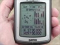
|   N37 W97 4.8 miles SE of Arkansas City, Cowley County, Kansas, USA N37 W97 4.8 miles SE of Arkansas City, Cowley County, Kansas, USA
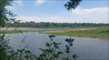
in Confluence Spots Another cow pasture posted by:  txoilgas txoilgas location: Kansas date approved: 01/16/2009 last visited: 04/22/2018 |
 view gallery view gallery W1 km W1 km
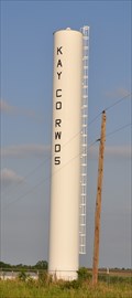
|  Kay County Rural Water District Column Kay County Rural Water District Column
in Water Towers This Water Column is located on the south side of 332nd Road, also known as State Line Road, just east of 3360 Road northeast of Newkirk, Oklahoma. posted by: brwhiz location: Oklahoma date approved: 02/22/2013 last visited: 11/17/2019 |
 view gallery view gallery NE1.9 km NE1.9 km
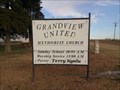
|  Grandview United Methodist Church - Bolton, KS Grandview United Methodist Church - Bolton, KS
in Country Churches Grandview United Methodist Church, with a congregation of 14, is several miles from the nearest (small) town - in rural southwest Cowley County, Kansas posted by: The Snowdog location: Kansas date approved: 07/10/2020 last visited: never |
 view gallery view gallery NW2.7 km NW2.7 km
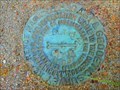
|  BOLTON AZ MK (HF1323) - Cowley County, Kansas BOLTON AZ MK (HF1323) - Cowley County, Kansas
in U.S. Benchmarks The azimuth mark for triangulation station BOLTON/BOLTON 2. posted by: Tom.dog location: Kansas date approved: 11/17/2022 last visited: 11/09/2018 |
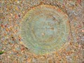 view gallery view galleryNW2.7 km |  BOLTON AZ MK (HF1323) - Cowley County, Kansas BOLTON AZ MK (HF1323) - Cowley County, Kansas
in Azimuth Benchmarks The azimuth mark for triangulation station BOLTON/BOLTON 2. posted by: Tom.dog location: Kansas date approved: 07/02/2023 last visited: 11/13/2018 |
 view gallery view galleryNW3.4 km | BOLTON 2 NO 3 - Cowley County, Kansas in U.S. Benchmarks Reference mark 3 for triangulation station BOLTON 2. posted by: Tom.dog location: Kansas date approved: 11/17/2022 last visited: 11/13/2018 |
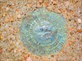 view gallery view galleryNW3.4 km | BOLTON 2 NO 4/5 - Cowley County, Kansas in U.S. Benchmarks Once RM4 for triangulation station BOLTON 2, this mark has been re-designated as RM5 for the same station. posted by: Tom.dog location: Kansas date approved: 11/17/2022 last visited: never |
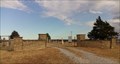 view gallery view galleryNE3.5 km |  Springside Cemetery - Arkansas City, KS Springside Cemetery - Arkansas City, KS
in Worldwide Cemeteries A small cemetery southeast of Arkansas City, Kansas posted by: The Snowdog location: Kansas date approved: 02/29/2020 last visited: never |
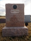 view gallery view galleryNE3.5 km |  John T. Boss - Arkansas City, KS John T. Boss - Arkansas City, KS
in Graves Mentioning a Cause of Death Major John T. Boss was killed in action near Chateau Thierry, France, in July 1918. posted by: The Snowdog location: Kansas date approved: 03/08/2020 last visited: never |
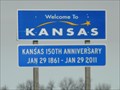 view gallery view galleryW4 km |  OK-KS on US 77 OK-KS on US 77
in Border Crossings A quiet border crossing on US Hwy 77 between Oklahoma and Kansas on a 4-lane divided highway. posted by: PeterNoG location: Kansas date approved: 04/27/2011 last visited: 04/24/2021 |
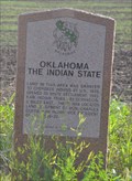 view gallery view galleryW4 km |  Oklahoma - The Indian State Oklahoma - The Indian State
in Oklahoma Historical Markers This Oklahome Historical marker is one of several located in a turnout on the west side of US Highway 77 just south of the Kansas/Oklahoma border north of Newkirk, Oklahoma. posted by: brwhiz location: Oklahoma date approved: 02/23/2013 last visited: 04/24/2021 |
 view gallery view galleryW4 km | Opening of the Cherokee Strip in Oklahoma Historical Markers This Oklahome Historical marker is one of several located in a turnout on the west side of US Highway 77 just south of the Kansas/Oklahoma border north of Newkirk, Oklahoma. posted by: brwhiz location: Oklahoma date approved: 02/23/2013 last visited: 11/09/2018 |
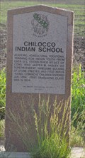 view gallery view galleryW4 km | Chilocco Indian School in Oklahoma Historical Markers This Oklahome Historical marker is one of several located in a turnout on the west side of US Highway 77 just south of the Kansas/Oklahoma border north of Newkirk, Oklahoma. posted by: brwhiz location: Oklahoma date approved: 02/23/2013 last visited: 11/09/2018 |
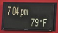 view gallery view gallery SW4.2 km SW4.2 km
|  First Council Casino ~ Newkirk, Oklahoma First Council Casino ~ Newkirk, Oklahoma
in Time and Temperature Signs The large monument sign for the casino on Highway 77 displays time and temperature as well as a wealth of other information. posted by: brwhiz location: Oklahoma date approved: 06/01/2012 last visited: 04/28/2021 |
 view gallery view gallerySW4.3 km |  First Council Casino ~ Newkirk, Oklahoma First Council Casino ~ Newkirk, Oklahoma
in Casinos This is the first casino you encounter as you enter Oklahoma from Kansas on US Highway 77. posted by: brwhiz location: Oklahoma date approved: 06/01/2012 last visited: 04/24/2021 |
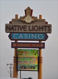 view gallery view gallerySW5 km | Native Lights Casino ~ Newkirk, Oklahoma in Casinos This casino is owned and operated by the Tonkawa Tribe of Native Americans. posted by: brwhiz location: Oklahoma date approved: 06/01/2012 last visited: 04/24/2021 |
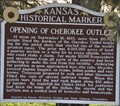
 view gallery view galleryNW5.1 km |  Opening of Cherokee Outlet ~ Arkansas City, Kansas, USA Opening of Cherokee Outlet ~ Arkansas City, Kansas, USA
in Human Migration Monuments This Historical Marker, commemorating the largest land rush in the Oklahoma Territory, is located in a small park between US Highway 77 and 61st Lane (Lovers Lane) at 306th Road just south of Arkansas City, Kansas. posted by: brwhiz location: Kansas date approved: 02/23/2013 last visited: 02/04/2017 |
 view gallery view galleryNW5.1 km |  Opening of Cherokee Outlet Opening of Cherokee Outlet
in Kansas Historical Markers This Kansas Historical Marker, that replaced an earlier version in 2012, is located in a small park between US Highway 77 and 61st Lane (Lovers Lane) at 306th Road just south of Arkansas City, Kansas. posted by: brwhiz location: Kansas date approved: 02/23/2013 last visited: 02/04/2017 |
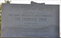 view gallery view galleryNW5.1 km | The Cherokee Strip in Kansas Historical Markers This Historical Marker is located in a turnout off of Quaker Haven Camp Road on the west side of US Highway just south of Arkansas City, Kansas. posted by: brwhiz location: Kansas date approved: 02/23/2013 last visited: 11/09/2018 |
 view gallery view galleryNW5.1 km | The Cherokee Strip ~ Arkansas City, Kansas, USA in Human Migration Monuments This Historical Marker, commemorating the largest land rush in the Oklahoma Territory, is located in a turnout off of Quaker Haven Camp Road on the west side of US Highway just south of Arkansas City, Kansas. posted by: brwhiz location: Kansas date approved: 02/23/2013 last visited: 11/09/2018 |
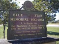 view gallery view galleryNW5.3 km |  Hwy. 77 North bound - Arkansas City, KS Hwy. 77 North bound - Arkansas City, KS
in Blue Star Memorial Highway Markers Wayside on south side of town posted by: beagle39z location: Kansas date approved: 10/03/2007 last visited: 02/04/2017 |
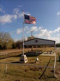 view gallery view galleryNW6.8 km |  Veterans Memorial - Arkansas City, KS Veterans Memorial - Arkansas City, KS
in Non-Specific Veteran Memorials A memorial to all veterans, with two individuals named on additional plaques. posted by: The Snowdog location: Kansas date approved: 12/27/2018 last visited: never |
 view gallery view gallery E6.8 km E6.8 km
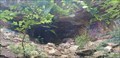
|  Belle Starr Falls - Newkirk, OK Belle Starr Falls - Newkirk, OK
in Waterfalls This small waterfall is just below a cave reputed to be a hideout used by notorious outlaw Belle Starr - northeast of Newkirk, Oklahoma. posted by: The Snowdog location: Oklahoma date approved: 06/29/2023 last visited: never |
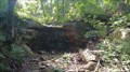
 view gallery view galleryE6.8 km | ") Belle Starr Cave - Newkirk, OK Belle Starr Cave - Newkirk, OK
in Cave Entrances (Natural) This shallow natural cave was reputed to be a hideout used by the notirious outlaw Belle Starr - northeast of Newkirk, Oklahoma. posted by: The Snowdog location: Oklahoma date approved: 06/28/2023 last visited: never |
 view gallery view galleryE6.9 km |  CONFLUENCE - Arkansas River and Otter Creek CONFLUENCE - Arkansas River and Otter Creek
in River Origins, Destinations and Confluences Otter Creek joins the Arkansas River at this location - just north of the Oklahoma-Kansas State line on the Arkansas River. posted by: The Snowdog location: Kansas date approved: 06/30/2023 last visited: never |
|