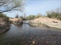
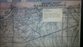
 view gallery view gallery E0 km E0 km
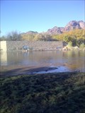
|   CONFLUENCE - Salt River and Verde River - Tonto National Forest, Arizona CONFLUENCE - Salt River and Verde River - Tonto National Forest, Arizona
in River Origins, Destinations and Confluences This is the confluence of the Salt River and the Verde River. posted by:  rjmcdonough1 rjmcdonough1 location: Arizona date approved: 03/03/2016 last visited: never |
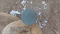
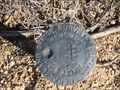
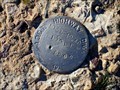
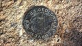 view gallery view galleryE0.8 km |  U.S. Geological Survey Benchmark 1343 Phnx U.S. Geological Survey Benchmark 1343 Phnx
in U.S. Benchmarks U.S. Geological Survey elevation benchmark 1343. This benchmark was determined by spirit leveling during a survey documented in 1904. The benchmark is noted on a USGS Topo Map dated 1904. posted by:  Azbarite Azbarite location: Arizona date approved: 12/30/2015 last visited: never |
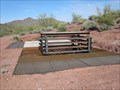
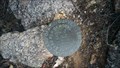
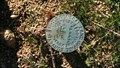
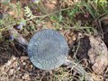 view gallery view gallery S1 km S1 km
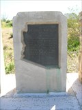
| U.S.General Land Office Survey 192.30 in U.S. Benchmarks This benchmark is located in the Tonto National Forest outside Phoenix, Arizona. posted by: rjmcdonough1 location: Arizona date approved: 03/01/2016 last visited: never |
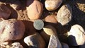
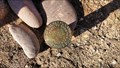 view gallery view gallery SW1 km SW1 km
| General Land Office Disk T2NR7E Section 5,6,7,8 in U.S. Benchmarks General Land Office disk marker at intersection of sections 5,6,7,8. Approximately 1 mile north of Bush Hwy and approximately 1700 feet west of Phon D. Sutton Rd. in Salt River Recreation Area near Mesa, AZ. posted by: Azbarite location: Arizona date approved: 12/22/2015 last visited: never |
 view gallery view gallery SE1.4 km SE1.4 km
| General Land Office Disk T2NR7E S4, S8, S9 in U.S. Benchmarks General Land Office disk marker at intersection of sections 4,8,9. Located approximately 100 feet west of hiking trail running north from horse trailer parking lot to top of Coon Bluff. posted by: Azbarite location: Arizona date approved: 04/01/2017 last visited: never |
 view gallery view gallerySW1.8 km |  Arizona Dam - Mesa, AZ Arizona Dam - Mesa, AZ
in Remains of Settlements An abandoned dam on the Salt River originally used to divert water into Phoenix's northern canals. Completed around 1890, washed out in 1905 and replaced with the Granite Reef Dam 2 miles downstream. posted by: Azbarite location: Arizona date approved: 01/04/2016 last visited: never |
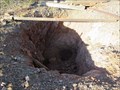
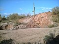
 view gallery view gallerySE1.8 km |  Arizona Barite Arizona Barite
in Mines An abandoned shaft and strip mine which extracted barite ore. Located on Coon Bluff in the Salt River Recreation Area northeast of Mesa, AZ. AKA; Granite Reef, Macco, Chrisman Barite, Mesa Barite Claims. posted by: Azbarite location: Arizona date approved: 12/25/2015 last visited: never |
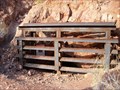 view gallery view galleryE1.9 km | ") Old Mine Mouth in Tonto National Forest - Maricopa County Arizona Old Mine Mouth in Tonto National Forest - Maricopa County Arizona
in Cave Entrances (Artificial) This old mine entrance has been reworked to allow bats to occupy the mine. posted by: rjmcdonough1 location: Arizona date approved: 12/11/2014 last visited: 02/11/2018 |
 view gallery view gallerySE2.6 km | Surprise Venture Shaft Mine (per AZGS) in Mines This is the site of an abandoned shaft mine listed as Surprise Venture with the Arizona Geological Survey. It is located south of Bush Hwy in the Salt River Recreation Area. AKA Big Red Mining Co. posted by: Azbarite location: Arizona date approved: 12/26/2015 last visited: never |
 view gallery view galleryE2.7 km | Remains of Sanchez Homestead in Remains of Settlements A site containing numerous artifacts indicative of rural homesteading. The area is marked "Sanchez" on the 1932 General Land Office Survey map. It is located in the Salt River Recreation Area near Mesa, AZ. posted by: Azbarite location: Arizona date approved: 12/29/2015 last visited: never |
 view gallery view galleryE2.7 km | General Land Office Disk T2NR7E S3 S4 North Corner in U.S. Benchmarks General Land Office disk marker at north corner of T2NR7E sect. 3,4. Located approximately 0.66 mile NNE of horse trailer parking area on Coon Bluff Rd. in Salt River Recreation Area near Mesa, AZ posted by: Azbarite location: Arizona date approved: 12/24/2015 last visited: never |
 view gallery view galleryS2.7 km | General Land Office Disk T2NR7E Sections 8,9,16,17 in U.S. Benchmarks General Land Office disk marker at intersection of sections 8,9,16,17. Approximately 0.75 mile south of Bush Hwy/Phone D Sutton Rd. intersection and approximately 170' south of "Wild Horse" bike trail in Salt River Recreation Area near Mesa, AZ. posted by: Azbarite location: Arizona date approved: 12/24/2015 last visited: never |
 view gallery view galleryE2.7 km | General Land Office Disk T2NR7E S3,S4,S9,S10 in U.S. Benchmarks General Land Office Disk at intersection of T2NR7E sections 3,4,9,10. It is located approximately 20 ft west of the Coon Bluff and Bush Highway intersection in Salt River Recreation Area near Mesa, Arizona. posted by: Azbarite location: Arizona date approved: 04/01/2017 last visited: never |
 view gallery view gallerySE2.7 km | Surprise Venture Surface Mine (Big Red) in Mines This is the site of an abandoned surface mine listed as Surprise Venture with the Arizona Geological Survey. It is located south of Bush Hwy in the Salt River Recreation Area. AKA Big Red Mining Co. posted by: Azbarite location: Arizona date approved: 12/25/2015 last visited: never |
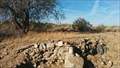 view gallery view galleryS3.1 km | Surprise Venture Mill Site in Mines This is the site of an abandoned mill associated with a mine listed as Surprise Venture with the Arizona Geological Survey. It is located south of Bush Hwy in the Salt River Recreation Area. AKA Big Red Mining Co. posted by: Azbarite location: Arizona date approved: 02/06/2016 last visited: never |
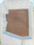
 view gallery view gallerySE3.1 km | U.S. General Land Survey 194 - Maricopa County, Arizona in U.S. Benchmarks This marker is located South of the Bush Highway in the Tonto National Forest in Arizona. posted by: rjmcdonough1 location: Arizona date approved: 11/08/2015 last visited: never |
 view gallery view gallerySE3.7 km | General Land Office Disk T2NR7E Sections 9,10,15,16 in U.S. Benchmarks General Land Office disk marker at intersection of sections 9,10,15,16. Located approximately 1 mile south of Coon Bluff/Bush Hwy intersection and approximately 1 mile west of Usery Rd. in Lower Salt River Recreation Area near Mesa, AZ. posted by: Azbarite location: Arizona date approved: 01/11/2016 last visited: never |
 view gallery view gallery NW4 km NW4 km
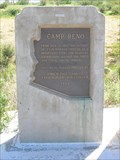
|  Camp Reno Camp Reno
in Arizona Historical Markers Camp Reno is on the Beeline Highway east of Scottsdale with two other markers. posted by: unimoggers location: Arizona date approved: 03/17/2008 last visited: 12/18/2014 |
 view gallery view galleryNW4 km | Fort McDowell in Arizona Historical Markers One of three markers located on the Beeline Highway, east of Scottsdale. posted by: unimoggers location: Arizona date approved: 03/17/2008 last visited: 02/12/2014 |
 view gallery view galleryNW4 km | Grave of DR. CARLOS MONTEZUMA in Arizona Historical Markers Arizona HM for the grave of an Apache Indian. posted by: unimoggers location: Arizona date approved: 03/17/2008 last visited: 12/18/2014 |
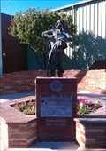
 view gallery view galleryNW4.3 km |  Gilbert Davis Jones Sr. - Ft. McDowell Mohave-Apache Indian Nation, Arizona Gilbert Davis Jones Sr. - Ft. McDowell Mohave-Apache Indian Nation, Arizona
in Citizen Memorials A plaque remembering the former President of the Ft. McDowell Community Council. posted by: sundevil1994 location: Arizona date approved: 11/27/2010 last visited: 02/12/2014 |
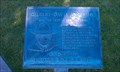
 view gallery view galleryNW4.3 km |  Fort McDowell Yavapai Nation Fort McDowell Yavapai Nation
in Municipal Flags The Fort McDowell Yavapai Nation flag flies above the casino near Fountain Hills, Arizona. posted by: unimoggers location: Arizona date approved: 03/15/2008 last visited: 02/12/2014 |
 view gallery view galleryNW4.3 km |  May 12, 1992 - Fort McDowell Yavapai Nation, Arizona May 12, 1992 - Fort McDowell Yavapai Nation, Arizona
in Civil Rights Memorials A monument remembering the community standing up to protect its right to exist as a sovereign nation after federal agents raided tribal (reservation) lands in 1992 posted by: sundevil1994 location: Arizona date approved: 11/27/2010 last visited: 02/12/2014 |
 view gallery view galleryE4.3 km | General Land Office Disk T2NR7E Sections 2,3,10,11 in U.S. Benchmarks General Land Office disk marker at intersection of sections 2,3,10,11. Approximately 0.25 mile south of Bush Hwy and approximately 0.30 miles west of Usery Rd. in Salt River Recreation Area near Mesa, AZ. posted by: Azbarite location: Arizona date approved: 12/24/2015 last visited: never |
 view gallery view gallery NE4.3 km NE4.3 km
| A.D.O.T. Highway Marker 1030 - Fountain Hills, AZ in U.S. Benchmarks This marker is on the north side of State Hwy. 87 at its intersection with the Fort McDowell Indian Community. posted by: rjmcdonough1 location: Arizona date approved: 01/06/2019 last visited: 12/29/2018 |
|