 view gallery view gallery W0.2 km W0.2 km
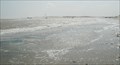
|   DESTINATION: Rio Grande River - Gulf of Mexico DESTINATION: Rio Grande River - Gulf of Mexico
in River Origins, Destinations and Confluences Located at the Border between Mexico and the United States of America. posted by:  8Nuts MotherGoose 8Nuts MotherGoose location: Texas date approved: 03/10/2007 last visited: 05/11/2023 |
 view gallery view gallery N2.3 km N2.3 km
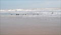
|  Wreck of the Montezuma Wreck of the Montezuma
in Shipwrecks Ribs of this wreck are still visible in the surf. posted by: 8Nuts MotherGoose location: Texas date approved: 03/10/2007 last visited: 02/01/2014 |
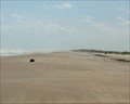
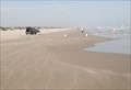 view gallery view galleryN4.3 km |  Boca Chica Beach, Texas Boca Chica Beach, Texas
in Free Overnight RV Parking Locations Enjoy the privacy of Boca Chica Beach posted by: 8Nuts MotherGoose location: Texas date approved: 03/11/2007 last visited: 05/11/2023 |
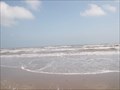 view gallery view galleryN4.3 km |  Boca Chica Beach - S.E. Texas Boca Chica Beach - S.E. Texas
in Beaches Coordinates are for the only access to the southern-most beach in Texas. posted by: 8Nuts MotherGoose location: Texas date approved: 11/24/2007 last visited: 05/11/2023 |
 view gallery view galleryN4.5 km |  Boca Chica Beach, Brownsville, Texas Boca Chica Beach, Brownsville, Texas
in Official Local Tourism Attractions To find a desolate stretch of beach you’d think you might need a boat, or at least a four-wheel drive, but on weekdays, twenty-three miles east of Brownsville, you can simply hop in your car and drive to your little piece of paradise. posted by:  JimmyEv JimmyEv location: Texas date approved: 12/29/2007 last visited: 05/11/2023 |
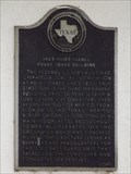
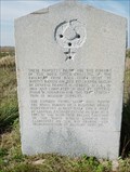 view gallery view galleryN4.8 km |  Boca Chica Palmetto Pilings Boca Chica Palmetto Pilings
in Texas Historical Markers Palmetto and Cypress pilings are remains of two military supply lines. posted by: 8Nuts MotherGoose location: Texas date approved: 03/11/2007 last visited: 05/11/2023 |
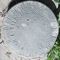 view gallery view gallery NW5.1 km NW5.1 km
|  USDI F&WS TR209-19, Mouth of the Rio Grande, TX USDI F&WS TR209-19, Mouth of the Rio Grande, TX
in U.S. Benchmarks Located in the Mouth of the Rio Grande Quadrangle on Hwy 4. posted by: 8Nuts MotherGoose location: Texas date approved: 07/27/2010 last visited: never |
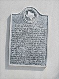
 view gallery view galleryW8.5 km | Camp Belknap in Texas Historical Markers Story of an Army camp during the Mexican American War. posted by: 8Nuts MotherGoose location: Texas date approved: 04/28/2007 last visited: 10/27/2023 |
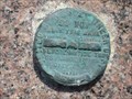 view gallery view galleryN12.1 km | United States Engineer Dept- Port Isabel Jetty in U.S. Benchmarks Badly damaged disc marker on the south jetty at the mouth of Port Isabel in South Texas. posted by: Teamcameron52 location: Texas date approved: 07/27/2011 last visited: 07/11/2011 |
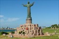
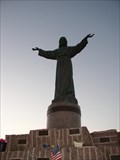 view gallery view galleryN12.7 km |  El Cristo de los Pescadores - South Padre Island, TX El Cristo de los Pescadores - South Padre Island, TX
in Maritime Monuments and Memorials The memorial titled "El Cristo de los Pescadores" which translates to "Christ of the Fishermen" is located at the Isla Blanca Park on South Padre Island in Texas, USA. posted by: Marine Biologist location: Texas date approved: 09/15/2008 last visited: 07/20/2016 |
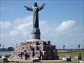 view gallery view galleryN12.7 km |  Mini Christ the Redeemer Statue - South Padre Island TX Mini Christ the Redeemer Statue - South Padre Island TX
in Roadside Attractions This Roadside Attraction is on the Channel View Loop in Isla Blanca Park at the south end of South Padre Island, Texas. posted by: PeterNoG location: Texas date approved: 04/20/2014 last visited: 07/29/2022 |
 view gallery view galleryN12.7 km | Brazos Santiago Pass and Brazos Island Military Depot in Texas Historical Markers General Zachary Taylor set-up a military camp across the water, in Brazos Santiago, to move supplies for the Mexican War. posted by: JimmyEv location: Texas date approved: 11/23/2007 last visited: 07/16/2015 |
 view gallery view galleryN12.7 km | Brazos Santiago, C.S.A. in Texas Historical Markers Brazos Santiago Pass and the town of Brazos Santiago, across the water from here, were the scene of many small skirmishes between Confederate and Union forces. posted by: JimmyEv location: Texas date approved: 11/23/2007 last visited: 07/16/2015 |
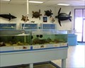 view gallery view galleryN12.9 km |  UTPA Coastal Studies Lab - South Padre Island, TX UTPA Coastal Studies Lab - South Padre Island, TX
in Science Museums Behind the beaches, hidden in the seagrass of Isla Blanca County Park, is this working lab, open to visitors a few hours every day (except Saturday). Inside is like an old-fashioned aquarium - lots of animals and exhibits but very little flash. posted by: JimmyEv location: Texas date approved: 04/06/2008 last visited: 01/31/2014 |
 view gallery view galleryN13.2 km | 1923 Point Isabel Coast Guard Building in Texas Historical Markers This Texas Historical Marker is on the west side of the 1923 Point Isabel Coast Guard Building on Wallace L Reed Road about 500 feet southwest of State Park Road 100 (Padre Road) on South Padre Island, Texas. posted by: PeterNoG location: Texas date approved: 01/24/2014 last visited: 07/16/2015 |
 view gallery view galleryW13.8 km |  Texas Tortoise - Brownsville, Texas Texas Tortoise - Brownsville, Texas
in Turtle Crossings This Texas tortoise was crossing Palmito Hill Road east of Brownsville, Texas. posted by: The A-Team location: Texas date approved: 10/08/2023 last visited: never |
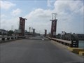 view gallery view galleryNW14 km |  Vertical Lift - Port Isabel Texas Vertical Lift - Port Isabel Texas
in Vertical Lift Bridges A small privately owned vertical lift bridge on the south side of Port Isabel posted by: Geojeepsters location: Texas date approved: 06/17/2009 last visited: 03/10/2018 |
 view gallery view galleryN14 km |  Isla Blanca Park, South Padre Island, Texas Isla Blanca Park, South Padre Island, Texas
in Municipal Parks and Plazas Stretching across the southern tip of South Padre Island, from the Gulf of Mexico to the Laguna Madre, is the heavily developed Isla Blanca Park. The beach here is as beautiful as the rest of the island, and the events seem endless. posted by: JimmyEv location: Texas date approved: 12/05/2007 last visited: 03/08/2018 |
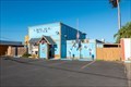 view gallery view galleryNW14.2 km |  American Legion Post 498 - Port Isabel, TX American Legion Post 498 - Port Isabel, TX
in Legion Posts and Branches The Indalecio Lopez American Legion Post 498 is located in a bright blue building at 819 South Garcia Street in Port Isabel, Texas. posted by: The A-Team location: Texas date approved: 01/21/2024 last visited: never |
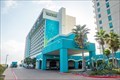 view gallery view galleryN14.2 km |  Margaritaville Beach Resort - South Padre Island, TX Margaritaville Beach Resort - South Padre Island, TX
in Jimmy Buffett This Margaritaville hotel is located on the resort island of South Padre Island in south Texas, at 310 Padre Boulevard. posted by: The A-Team location: Texas date approved: 01/21/2024 last visited: never |
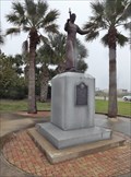
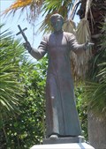 view gallery view galleryN14.5 km |  Padre Jose Nicolas Balli -- South Padre Island, TX Padre Jose Nicolas Balli -- South Padre Island, TX
in Statues of Historic Figures The statue of Padre Jose N. Balli, namesake and at one time the grantee of all of Padre Island posted by: Benchmark Blasterz location: Texas date approved: 08/13/2015 last visited: 05/12/2023 |
 view gallery view galleryN14.5 km | Padre J. Nicolas Balli in Texas Historical Markers History of the settling of Padre Island. posted by: 8Nuts MotherGoose location: Texas date approved: 04/27/2007 last visited: 05/12/2023 |
 view gallery view galleryN14.5 km |  Padre Jose Nicolas Balli - South Padre TX Padre Jose Nicolas Balli - South Padre TX
in Smithsonian Art Inventory Sculptures This Smithsonian Art Inventory Sculpture is in the park at the east end of the Queen Isabella Causeway, 300 feet east of (behind) the South Padre Island Welcome sign on South Padre Island, Texas. posted by: PeterNoG location: Texas date approved: 04/12/2014 last visited: 05/12/2023 |
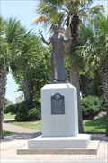 view gallery view galleryN14.5 km |  Padre Jose N. Balli -- South Padre Island TX Padre Jose N. Balli -- South Padre Island TX
in Statues of Religious Figures The statue of Padre Jose N. Balli, namesake and at one time the grantee of all of Padre Island posted by: Benchmark Blasterz location: Texas date approved: 08/15/2015 last visited: 05/12/2023 |
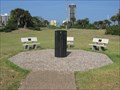 view gallery view galleryN14.5 km |  Causeway Collapse - South Padre Island Causeway Collapse - South Padre Island
in Disaster Memorials A monument for the victims and survivors of the Queen Isabella Causeway collapse in 2001. posted by: Geojeepsters location: Texas date approved: 06/17/2009 last visited: 05/12/2023 |
|