 view gallery view gallery E25.7 km E25.7 km
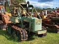
|   ÖSA BMB 230 "Bamse" - Överkalix, Norrbottens Län, Sweden ÖSA BMB 230 "Bamse" - Överkalix, Norrbottens Län, Sweden
in Old Tractors There are lots of tractors in "Holgers Traktormuseum" in Överkalix, mainly from the 1920ies to the 1970ies. posted by:  FamilieFrohne FamilieFrohne location: Norrbotten, Sweden date approved: 07/27/2023 last visited: never |
 view gallery view gallery NW43.5 km NW43.5 km
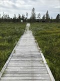
|  Arctic Circle Boardwalk - Nattavaara, Sweden Arctic Circle Boardwalk - Nattavaara, Sweden
in Non-Coastal Boardwalks Boardwalk leading into the Arctic Circle Monument and the Ore Road. posted by: Walking Boots location: Norrbotten, Sweden date approved: 01/16/2022 last visited: never |
 view gallery view galleryNW43.5 km |  Malmens väg - Nattavaara, Sweden Malmens väg - Nattavaara, Sweden
in Offroad Trails The Ore Road is a historic road from 1745 where you can only ride a snowmobile or ATV posted by: Walking Boots location: Norrbotten, Sweden date approved: 01/13/2022 last visited: never |
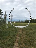 view gallery view galleryNW43.5 km |  Arctic Circle - The Magic Circle - Nattavaara, Sweden Arctic Circle - The Magic Circle - Nattavaara, Sweden
in Great Lines of Earth After a couple of hours driving on gravel roads in Swedish Lapland, you pass the Arctic Circle, which here is marked with a monument, The Magic Circle posted by: Walking Boots location: Norrbotten, Sweden date approved: 08/17/2021 last visited: never |
 view gallery view gallery SW66.1 km SW66.1 km
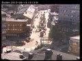
|  Boden kommuns webkamera Boden kommuns webkamera
in Web Cameras Boden kommuns kontrollerbara webbkamera. posted by: pekkaplanet location: Norrbotten, Sweden date approved: 08/19/2013 last visited: never |
 view gallery view gallery S80.8 km S80.8 km
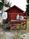
|  Milk Platform - Open-air museum Hägnan - Luleå, Sweden Milk Platform - Open-air museum Hägnan - Luleå, Sweden
in Milk Platforms - Maitolaiturit This milk platform can be seen in the Open-air museum Hägnan posted by: Walking Boots location: Norrbotten, Sweden date approved: 09/25/2021 last visited: never |
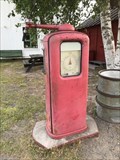 view gallery view galleryS80.8 km |  Gasoline Pump - Open-air museum Hägnan - Luleå, Sweden Gasoline Pump - Open-air museum Hägnan - Luleå, Sweden
in Vintage Gasoline Pumps This gasoline pump can be seen in the Open-air museum Hägnan posted by: Walking Boots location: Norrbotten, Sweden date approved: 09/25/2021 last visited: never |
 view gallery view galleryS81.1 km |  Church Town of Gammelstad, Luleå - Luleå, Norbottens Län, Sweden Church Town of Gammelstad, Luleå - Luleå, Norbottens Län, Sweden
in World Heritage Sites The area of the church village in Luleå is inscribed on the UNESCO World Heritage list since 1996 under the ID 762. The village with ist 424 houses was used by the farmers only on the night from Saturday to Sunday for the church visit. posted by: FamilieFrohne location: Norrbotten, Sweden date approved: 04/11/2021 last visited: 08/09/2021 |
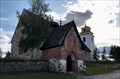 view gallery view galleryS81.1 km |  Norra Stegport - Nederluleå kyrka - Luleå, Sweden Norra Stegport - Nederluleå kyrka - Luleå, Sweden
in Lychgates and Depositories Nederluleå Church is surrounded by a wall in which two lychgates are preserved. The northern lychgate (Norra Stegport) is the largest and the most detailed posted by: Walking Boots location: Norrbotten, Sweden date approved: 08/09/2021 last visited: 08/10/2021 |
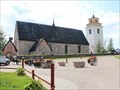
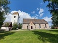 view gallery view galleryS81.1 km |  Nederluleå Church - Luleå, Norrbottens Län, Sweden Nederluleå Church - Luleå, Norrbottens Län, Sweden
in Wikipedia Entries Article on the Nederluleå Church in Gammelstad near Luleå in Norrbottens Län, Sweden. posted by: FamilieFrohne location: Norrbotten, Sweden date approved: 04/11/2021 last visited: 08/09/2021 |
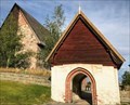 view gallery view galleryS81.1 km | . Västra Stegport - Nederluleå kyrka - Luleå, Sweden in Lychgates and Depositories Nederluleå Church is surrounded by a wall in which two lychgates are preserved. The western lychgate ( Västra Stegport) is built of stone and wood and does not have many details. posted by: Walking Boots location: Norrbotten, Sweden date approved: 08/09/2021 last visited: never |
 view gallery view galleryS81.1 km |  Nederluleå Kyrka - Luleå, Norbottens Län, Sweden Nederluleå Kyrka - Luleå, Norbottens Län, Sweden
in Medieval Churches The Lutheran church "Nederluleå Kyrka" in Gammelstad near Luleå is the largest medieval church in the Swedish land of Norrland. posted by: FamilieFrohne location: Norrbotten, Sweden date approved: 04/11/2021 last visited: 08/09/2021 |
 view gallery view galleryS81.1 km |  Gammelstad Church Town - Luleå, Norbottens Län, Sweden Gammelstad Church Town - Luleå, Norbottens Län, Sweden
in Official Local Tourism Attractions The old church town of Gammelstad near Luleå displays the unique features of a village used only for weekends since the 16th century. posted by: FamilieFrohne location: Norrbotten, Sweden date approved: 04/12/2021 last visited: 08/09/2021 |
 view gallery view galleryS91.2 km |  Luleå Airport - Luleå, Sweden Luleå Airport - Luleå, Sweden
in Airports Luleå Airport began as a military airfield in 1941 and from 1944, civil air traffic was allowed from Luleå. posted by: Walking Boots location: Norrbotten, Sweden date approved: 10/07/2021 last visited: never |
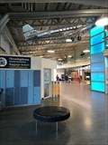 view gallery view galleryS91.2 km |  Luleå Airport - Luleå, Sweden Luleå Airport - Luleå, Sweden
in Inside Airports Luleå Airport began as a military airfield in 1941 and from 1944, civil air traffic was allowed from Luleå. posted by: Walking Boots location: Norrbotten, Sweden date approved: 10/07/2021 last visited: never |
 view gallery view galleryNW102.5 km |  Stenbron - Gällivare, Norrbottens Län, Sweden Stenbron - Gällivare, Norrbottens Län, Sweden
in Arch Bridges A small stone bridge with three arches leads over the river Vassaraälven. posted by: FamilieFrohne location: Norrbotten, Sweden date approved: 06/14/2022 last visited: never |
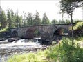 view gallery view galleryNW102.5 km |  Stenbron - Gällivare, Norrbottens Län, Sweden Stenbron - Gällivare, Norrbottens Län, Sweden
in Stone Bridges A small stone bridge with three arches leads over the river Vassaraälven. posted by: FamilieFrohne location: Norrbotten, Sweden date approved: 06/21/2022 last visited: never |
 view gallery view galleryS141 km |  Ford Anglia in Jävre Touristinformation - Jävre, Norrbottens Län, Sweden Ford Anglia in Jävre Touristinformation - Jävre, Norrbottens Län, Sweden
in Permanent Car Displays There is an old Ford 105 E Anglia in the touristinformation in Jävre. posted by: FamilieFrohne location: Norrbotten, Sweden date approved: 05/10/2023 last visited: never |
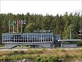 view gallery view galleryS141 km |  Jävre Touristinformation - Jävre, Norrbottens Län, Sweden Jävre Touristinformation - Jävre, Norrbottens Län, Sweden
in Googie Architecture The futuristic looking tourist information center at the E4 near the county border of Norrbotten and Västerbotten was built in 1967. posted by: FamilieFrohne location: Norrbotten, Sweden date approved: 08/19/2021 last visited: 07/31/2022 |
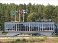
 view gallery view galleryS141 km |  Jävre Touristinformation - Jävre, Norrbottens Län, Sweden Jävre Touristinformation - Jävre, Norrbottens Län, Sweden
in Tourist Information Centers - Visitor Centers The Touriscenter Jävre is just along the E4 south of Piteå. posted by: FamilieFrohne location: Norrbotten, Sweden date approved: 12/05/2020 last visited: 07/31/2022 |
 view gallery view galleryS141 km | Jävre turiststation - Jävre, Norrbottens Län, Sweden in Wikipedia Entries Article on the tourist center in Jävre new Piteå. posted by: FamilieFrohne location: Norrbotten, Sweden date approved: 12/05/2020 last visited: 07/31/2022 |
 view gallery view galleryS141 km |  Jävre turiststation - Jävre, Norrbottens Län, Sweden Jävre turiststation - Jävre, Norrbottens Län, Sweden
in Nordic Heritage The tourist information center at the E4 near the county border of Norrbotten and Västerbotten was built in 1967 with futuristic looks and put on the list in June 2003. posted by: FamilieFrohne location: Norrbotten, Sweden date approved: 01/16/2023 last visited: never |
|