 view gallery view gallery W4.7 km W4.7 km
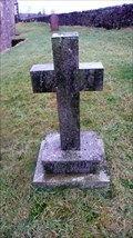
|   Edith Caroline Rivett, Aughton, Lancashire Edith Caroline Rivett, Aughton, Lancashire
in Grave of a Famous Person Edith Caroline Rivett was a prolific detective crime authoress. She used many pseudonyms. Carol Carnac, E C R Lorac, Carol Rivett, Mary le Bourne. Her work has a dedicated following although no longer in print. posted by:  flipflopnick flipflopnick location: North West England, United Kingdom date approved: 12/24/2012 last visited: never |
 view gallery view gallery NE4.8 km NE4.8 km
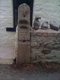
|  Toll Bar House Cut Benchmark. Low Bentham. North Yorkshire. UK Toll Bar House Cut Benchmark. Low Bentham. North Yorkshire. UK
in U.K. and Ireland Trigpoints Located on a gate stoop outside the Toll Bar house on the B6480, in between Wennington and Low Bentham. North Yorkshire. posted by:  thebigchip thebigchip location: United Kingdom date approved: 07/13/2009 last visited: never |
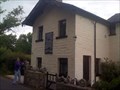 view gallery view galleryNE4.8 km |  Toll Bar House, Low Bentham. UK Toll Bar House, Low Bentham. UK
in Bygone Toll Houses Situated on the B6480 between Wennington and Low Bentham. This also is a waymark for a cut bench mark. posted by: thebigchip location: United Kingdom date approved: 07/13/2009 last visited: never |
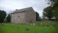 view gallery view galleryNE6 km |  Calf Cop Meeting House, Low Bentham Calf Cop Meeting House, Low Bentham
in Quaker Meeting Houses Calf Cop is still used as a Meeting House, with parking for three cars. There is a still active burial ground around the building. posted by: flipflopnick location: Yorkshire, United Kingdom date approved: 10/29/2009 last visited: never |
 view gallery view galleryW6.4 km |  Historic flood levels,River Lune.Waterworks Bridge. Historic flood levels,River Lune.Waterworks Bridge.
in River Gauges The River Lune,is crossed here by the Aqueduct bridge carrying water from Thirlmere in the lake district to the city of Manchester,carved into the stone work are Historical flood level markers. posted by: fellsmanhiker location: United Kingdom date approved: 04/03/2008 last visited: 04/04/2008 |
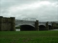 view gallery view galleryW6.4 km |  The River Lune Waterworks Bridge. The River Lune Waterworks Bridge.
in Arch Bridges The River Lune Aqueduct bridge near Caton Lancashire England is a pipe bridge and carries water from Thirlmere in the Lake district of Cumbria to Manchester. posted by: fellsmanhiker location: United Kingdom date approved: 04/03/2008 last visited: 02/27/2011 |
 view gallery view galleryW6.4 km |  The River Lune-Historical high level flood marker. The River Lune-Historical high level flood marker.
in High Level Marks The river Lune is crossed at this point by Waterworks bridge,the bridge shows carved markers for past flood levels.
The bridge can be reached by public footpath from Caton,Lancashire. posted by: fellsmanhiker location: North West England, United Kingdom date approved: 10/02/2008 last visited: 10/08/2008 |
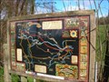 view gallery view gallery E7.1 km E7.1 km
|  Bentham Heritage Trail, N Yorkshire Bentham Heritage Trail, N Yorkshire
in 'You Are Here' Maps Bentham Heritage Trail is marked out with a delightful series of geocaches. This is the map you need at the start at the cattle grid to St. Margaret Church. posted by: flipflopnick location: Yorkshire, United Kingdom date approved: 03/24/2008 last visited: 02/16/2009 |
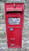
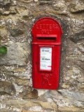 view gallery view galleryE7.2 km |  Victorian Wall Post Box - High Bentham, Yorkshire, UK Victorian Wall Post Box - High Bentham, Yorkshire, UK
in Victorian Post Boxes A very rare Victorian lamp post box in High Bentham in Yorkshire posted by: ntpayne location: Yorkshire, United Kingdom date approved: 08/13/2018 last visited: never |
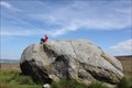 view gallery view galleryE7.4 km |  The Great Stone of Fourstones The Great Stone of Fourstones
in Places of Geologic Significance The Great Stone of Fourstones
This is an absolute cracker! It is HUGE and you can see it as you drive along the moor from Bentham. Fantastic views over to Ingleborough; climb up the carved steps and sit a-top this huge piece of stone and just gaze upon the view. A big old lump of rock in the middle of a very bleak and often featureless moor which makes it very hard to miss! posted by: angellica location: East Midlands, United Kingdom date approved: 07/17/2011 last visited: 12/12/2014 |
 view gallery view galleryW7.9 km |  St.Cuthbert's church-Over Kellet, Lancashire England. St.Cuthbert's church-Over Kellet, Lancashire England.
in This Old Church St.Cuthbert's church dates from the 13th Century,though there has been a church here on this site since 1251 posted by: fellsmanhiker location: North West England, United Kingdom date approved: 01/03/2010 last visited: never |
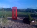 view gallery view galleryW7.9 km |  Meadow View Caravan Park, Nether Kellet, Carnforth. UK Meadow View Caravan Park, Nether Kellet, Carnforth. UK
in Red Telephone Boxes Used as part of a display of old farm equipment on a caravan park. there is no glass or phone, but is in very good condition. posted by: thebigchip location: United Kingdom date approved: 06/28/2009 last visited: never |
 view gallery view gallery N8 km N8 km
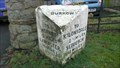
|  Burrow Road Milestone, Burrow, Lancashire Burrow Road Milestone, Burrow, Lancashire
in Milestones A large stone distance marker along the old Lancaster to Kirkby Stephen turnpike, showing distances to towns on route and current parish. Well cared for. Grade 2 listed structure. posted by: flipflopnick location: North West England, United Kingdom date approved: 01/17/2013 last visited: never |
 view gallery view galleryN8 km | Burrow Victorian Postbox, Lancashire in Victorian Post Boxes The Postbox is embedded in the wall of a barn at the junction of Woodman Lane and Burrow Road. LA6 151 posted by: flipflopnick location: North West England, United Kingdom date approved: 01/18/2013 last visited: never |
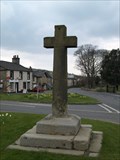 view gallery view galleryW8.2 km |  Old Cross at Over Kellett, Lancashire Old Cross at Over Kellett, Lancashire
in Christian Crosses An interesting old Christian cross sited on the village green in Over Kellett. posted by: Sir Lose-a-lot location: United Kingdom date approved: 04/30/2008 last visited: 04/16/2008 |
 view gallery view gallery NW8.2 km NW8.2 km
|  Arch Bridge 131 On The Lancaster Canal - Capenwray, UK Arch Bridge 131 On The Lancaster Canal - Capenwray, UK
in Stone Bridges This single arch stone bridge over the Lancaster Canal is an accommodation bridge for a nearby farm, and is known as Capenwray Bridge. posted by: dtrebilc location: United Kingdom date approved: 09/23/2016 last visited: never |
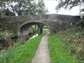 view gallery view galleryNW8.2 km | Stone Bridge 131 On The Lancaster Canal - Capenwray, UK in Arch Bridges This single arch stone bridge over the Lancaster Canal is an accommodation bridge for a nearby farm, and is known as Capenwray Bridge. posted by: dtrebilc location: North West England, United Kingdom date approved: 09/23/2016 last visited: never |
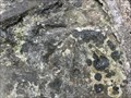 view gallery view galleryNW8.2 km | Cut Mark On Bridge 131 On Lancaster Canal - Capernwray, UK in U.K. and Ireland Trigpoints This Cut Mark is on the arch stones of bridge 131, an accommodation bridge for a nearby farm over the canal. posted by: dtrebilc location: North West England, United Kingdom date approved: 09/23/2016 last visited: never |
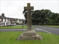 view gallery view galleryW8.2 km | Village Cross -Over Kellet, UK in Christian Crosses This stone cross is on the village green, next to the cross roads consisting of Nether Kellet Road and Kellet Road. posted by: dtrebilc location: North West England, United Kingdom date approved: 09/12/2016 last visited: never |
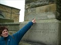
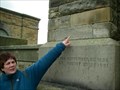
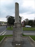 view gallery view galleryW8.2 km |  Village War Memorial in Over Kellett, Lancs Village War Memorial in Over Kellett, Lancs
in Non-Specific Veteran Memorials An unusual War Memorial sited on Over Kellett village green. posted by: Sir Lose-a-lot location: United Kingdom date approved: 04/30/2008 last visited: 09/05/2016 |
 view gallery view galleryW8.2 km |  World War I Deaths - Over Kellett, UK World War I Deaths - Over Kellett, UK
in Broken Column Headstones This broken column is unusual because it has been used as a World War I memorial for men of the parish who fought and fell. This truly is a fitting memorial for those lives cut short. posted by: dtrebilc location: North West England, United Kingdom date approved: 09/09/2016 last visited: never |
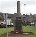
 view gallery view galleryW8.2 km |  Combined World War I And World War II Memorial – Over Kellet, UK Combined World War I And World War II Memorial – Over Kellet, UK
in World War I Memorials and Monuments This war memorial is in the form of a broken round column on a square base. posted by: dtrebilc location: North West England, United Kingdom date approved: 09/09/2016 last visited: never |
 view gallery view galleryW8.2 km |  Black Pump, Kellet Road, Over Kellet, Lancashire Black Pump, Kellet Road, Over Kellet, Lancashire
in Hand Operated Water Pumps This pump is beside the main east west road in Over Kellet, attached to the wall on a recently renewed wooden board. posted by: flipflopnick location: North West England, United Kingdom date approved: 12/18/2013 last visited: never |
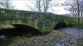 view gallery view galleryN8.4 km | Burrow Bridge, Lancashire in Stone Bridges Burrow Bridge is a fine stone bridge which carries the A683 main road over Leck Beck just before the river merges with the Lune River. posted by: flipflopnick location: North West England, United Kingdom date approved: 01/17/2013 last visited: never |
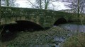 view gallery view galleryN8.4 km | Burrow Bridge, Burrow, Lancashire in Arch Bridges Burrow Bridge has been here in many forms since before 1695 when it is shown on a map. The current structure is the result of re-widening in 1968. Bridge not a listed structure. posted by: flipflopnick location: North West England, United Kingdom date approved: 01/17/2013 last visited: never |
|