  SE2.1 km SE2.1 km
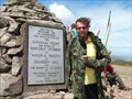
|   Selworthy Beacon Selworthy Beacon
in U.K. and Ireland Trigpoints Stone-built trigpoint atop Selworthy Beacon. posted by:  lackofluke lackofluke location: United Kingdom date approved: 01/03/2006 last visited: 08/01/2006 |
 view gallery view gallery S4.7 km S4.7 km
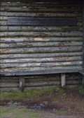
|  Alfred Vowles - Horner Hill, Exmoor, Somerset, UK Alfred Vowles - Horner Hill, Exmoor, Somerset, UK
in Dedicated Benches A bench in the Jubilee Hut at the top of Horner Hill on Exmoor dedicated to Alfred Vowles who was a writer, photographer and conservationist. . posted by:  Superted Superted location: South West England, United Kingdom date approved: 02/10/2010 last visited: never |
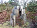 view gallery view galleryS4.8 km |  Play time - Webber’s Post Sculpture Trail, Exmoor, UK. Play time - Webber’s Post Sculpture Trail, Exmoor, UK.
in Outside Wooden Display Carvings ‘Play time’ is a complex structure built by Estonian schoolteacher Toomas Mitt, using four very large beech logs. The four sections are cut to produce steps giving an idea of how big the original logs were. posted by: Superted location: South West England, United Kingdom date approved: 02/11/2010 last visited: never |
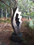 view gallery view galleryS4.8 km | Butterfly - Webber’s Post Sculpture Trail, Exmoor, UK in Outside Wooden Display Carvings ‘Butterfly’, by Estonian sculptor Katre Lember is tucked under the trees, is carefully placed, almost secretly, as an insect might rest. posted by: Superted location: South West England, United Kingdom date approved: 02/11/2010 last visited: never |
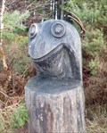 view gallery view galleryS5 km | Frog Kingdom - Webber’s Post Sculpture Trail, Exmoor, UK in Outside Wooden Display Carvings ‘Frog Kingdom’ by Heiki Kongi from Tallinn wears a steel crown symbolising Estonia flanked by Russia and neighbouring countries. posted by: Superted location: South West England, United Kingdom date approved: 02/12/2010 last visited: never |
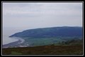
 view gallery view galleryS7.4 km |  Dunkery Beacon Dunkery Beacon
in Mountain Summits Dunkery Beacon (G/SC-001)
This is the highest summit in Exmoor.
To claim this waypoint you need to send a picture of yourself next to the trig. point. posted by: charlieg0pzo location: United Kingdom date approved: 08/05/2006 last visited: 08/22/2019 |
 view gallery view gallery E7.6 km E7.6 km
|  South West Coast Path Minehead Trailhead South West Coast Path Minehead Trailhead
in Hiking and walking trailheads The South West Coast Path is a National Trail of 630 miles in the South West of England. posted by: MTBpointer location: South West England, United Kingdom date approved: 04/13/2020 last visited: 08/06/2012 |
 view gallery view galleryE7.6 km |  South West Coast Path Northern Trailhead, Minehead South West Coast Path Northern Trailhead, Minehead
in Long Distance Hiking Trails The South West Coast Path is a National Trail of 630 miles in the South West of England. posted by: MTBpointer location: West Midlands, United Kingdom date approved: 01/12/2021 last visited: 01/13/2021 |
 view gallery view galleryE8.4 km |  Hidden Histories Map - Minehead, Somerset, UK Hidden Histories Map - Minehead, Somerset, UK
in 'You Are Here' Maps The hidden Histories map which shows multiple history trails in Minehead. The map also includes a 'you are here' marker. posted by: FingerpostSeries location: South West England, United Kingdom date approved: 08/09/2023 last visited: never |
 view gallery view gallery SW11.4 km SW11.4 km
|  The Exmoor National Park The Exmoor National Park
in National Parks of the World The Exmoor National Park posted by: Waupe location: South West England, United Kingdom date approved: 01/04/2011 last visited: 08/08/2010 |
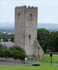 view gallery view gallerySE12.2 km |  Tower of St Hilary's Church, Denbigh - Wales. Tower of St Hilary's Church, Denbigh - Wales.
in Wikipedia Entries St Hilary's Chapel was built as a Chapel of Ease around 1300 AD. The Church was abandoned in 1875 & partially demolished in 1923. Today only the 50 feet tall Bell Tower survives. Located just outside Denbigh Castle, Vale of Clwyd, North Wales. posted by: veritas vita location: North Wales, United Kingdom date approved: 08/04/2017 last visited: 08/05/2017 |
SE12.9 km | Croydon Hill (Somerset) in U.K. and Ireland Trigpoints In the open land near Croydon Hill forest. posted by: lackofluke location: United Kingdom date approved: 01/03/2006 last visited: never |
 view gallery view gallery W13 km W13 km
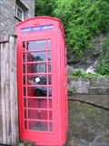
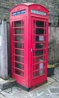
|  Red Telephone Box - Lynmouth, Devon, UK Red Telephone Box - Lynmouth, Devon, UK
in Red Telephone Boxes Phone box in the tourist town of Lynmouth. posted by: hyperheidi location: United Kingdom date approved: 10/03/2011 last visited: 03/11/2016 |
 view gallery view gallerySE13.2 km | Luxborough Church, Exmoor in U.K. and Ireland Trigpoints A bench Mark on Exmoor, Somerset posted by: Grimspound and Jem location: United Kingdom date approved: 10/09/2007 last visited: 10/05/2007 |
W15.1 km | Butter Hill (Devon) in U.K. and Ireland Trigpoints On the north coast of Devon, overlooking Lynmouth and the Foreland. posted by: lackofluke location: United Kingdom date approved: 01/03/2006 last visited: 03/10/2016 |
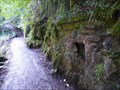 view gallery view galleryW16.7 km |  Lynrock Fountain - Lynmouth, Devon, UK Lynrock Fountain - Lynmouth, Devon, UK
in Preserved Architectural Remnants and Ruins The Lynrock Fountain used to be a mineral water factory. Now, all that remains is the old fireplace, a plaque and a bottle encased in the bank, preserving history. posted by: Dragontree location: South West England, United Kingdom date approved: 11/28/2017 last visited: never |
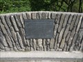 view gallery view galleryW16.7 km |  Chiselcombe Bridge HM - Watersmeet Walk, Lynmouth, Devon, UK Chiselcombe Bridge HM - Watersmeet Walk, Lynmouth, Devon, UK
in UK Historical Markers This bridge is a replacement after the original was washed away in the horrific floods of 1952. posted by: Dragontree location: South West England, United Kingdom date approved: 11/28/2017 last visited: never |
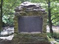 view gallery view galleryW17.1 km | The Watersmeet Valley Property - Lynmouth, Devon, UK in UK Historical Markers At the start of the Watersmeet path in Lynmouth this plaque can be found. posted by: Dragontree location: South West England, United Kingdom date approved: 11/28/2017 last visited: never |
 view gallery view galleryS17.2 km |  Tarr Steps, Somerset, England Tarr Steps, Somerset, England
in Philatelic Photographs A stone clapper bridge crossing the River Barle in Exmoor National Park is portrayed on this 1968 postage stamp from Great Britain. posted by: hykesj location: South West England, United Kingdom date approved: 04/03/2020 last visited: 02/02/2016 |
 view gallery view galleryW17.7 km | Red Telephone Box - Lynmouth Street, Lynton, Devon in Red Telephone Boxes Public Red Telephone Box - Lynmouth Street, Lynton, Devon, UK posted by: kilkenny_blake location: South West England, United Kingdom date approved: 06/03/2011 last visited: 03/11/2016 |
 view gallery view galleryW18 km |  Lynmouth/Lynton Cliff Railway, Devon, UK Lynmouth/Lynton Cliff Railway, Devon, UK
in Public Funiculars and Incline Railways The Lynmouth/Lynton Cliff Railway is a Victorian era water powered funicular lift from the sea shore town of Lynmouth to the upper town of Lynton. Coordinates are for the Lynton(upper) terminal posted by: hyperheidi location: South West England, United Kingdom date approved: 10/02/2011 last visited: 08/05/2017 |
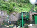
 view gallery view gallerySW19.3 km |  Pinkery Outdoor Centre photovoltaic roof - Exmoor, UK Pinkery Outdoor Centre photovoltaic roof - Exmoor, UK
in Solar Power A roof at the Pinkery Outdoor Centre has been covered in photovoltaic tiles. posted by: Superted location: South West England, United Kingdom date approved: 05/07/2011 last visited: never |
 view gallery view gallery N19.3 km N19.3 km
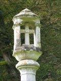
|  St Donats - Churchyard Cross - St Donats, Wales, Great Britain. St Donats - Churchyard Cross - St Donats, Wales, Great Britain.
in Churchyard Crosses This Churchyard Cross is from the 1800 hundreds, located in St Donats church. which lies in the shadow of the medieval castle, St Donats is a Norman church believed to date back to circa 1100. posted by: veritas vita location: South Wales, United Kingdom date approved: 08/10/2013 last visited: 01/08/2013 |
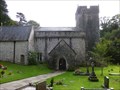 view gallery view galleryN19.3 km |  St Donats - Church in Wales - St Donats, Wales, Great Britain. St Donats - Church in Wales - St Donats, Wales, Great Britain.
in Anglican and Episcopal Churches St Donats Church - Parish of Welsh St Donants - Dioceses of Llandaff - Church In Wales. The Church lies in the shadow of the medieval St Donats Castle which shares its name. St Donats is a Norman church believed to date back to circa 1100 posted by: veritas vita location: South Wales, United Kingdom date approved: 08/10/2013 last visited: 01/08/2013 |
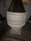 view gallery view galleryN19.3 km |  Norman Font - St Donats Church - Vale of Glamorgan, Wales. Norman Font - St Donats Church - Vale of Glamorgan, Wales.
in Stone Church Artefacts St Donats church lies in the shadow of the medieval castle which shares its name. St Donats a Norman church has a font believed to date back to circa 1100 AD. Located in the Vale of Glamorgan, South Wales. posted by: veritas vita location: South Wales, United Kingdom date approved: 01/14/2014 last visited: 01/01/2014 |
|