 view gallery view gallery NW1.8 km NW1.8 km
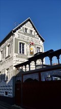
|   Modern-Antique-Symbiose - Bad Camberg / Erbach - Germany - Hessia Modern-Antique-Symbiose - Bad Camberg / Erbach - Germany - Hessia
in Murals A house with antique motives having items coming from modern live. posted by:  ColleIsarco ColleIsarco location: Hessen, Germany date approved: 09/15/2019 last visited: never |
 view gallery view gallery S6.3 km S6.3 km
|  Thai Town - Bad Camberg / Erbach - Germany - Hessia Thai Town - Bad Camberg / Erbach - Germany - Hessia
in Thai Restaurants A Thai restaurant in Bad Camberg posted by: ColleIsarco location: Hessen, Germany date approved: 07/04/2019 last visited: never |
 view gallery view galleryS8.5 km |  Unionskirche - Idstein, Germany Unionskirche - Idstein, Germany
in Medieval Churches Historic church in the center of town. posted by:  flyingmoose flyingmoose location: Rheinland-Pfalz, Germany date approved: 01/27/2024 last visited: never |
 view gallery view galleryS8.5 km |  Unionskirche - Idstein, Germany Unionskirche - Idstein, Germany
in Lutheran Churches Historic church in the center of town. posted by: flyingmoose location: Hessen, Germany date approved: 01/27/2024 last visited: never |
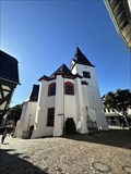 view gallery view galleryS8.5 km |  Unionskirche - Idstein, Germany Unionskirche - Idstein, Germany
in Deutsche Denkmallisten - German Monument Registers A church in the center of Idstein. posted by: flyingmoose location: Hessen, Germany date approved: 01/25/2024 last visited: never |
 view gallery view galleryS8.5 km |  Bike rack - Alstadt Bike rack - Alstadt
in Bicycle Tenders A unique Bike stand in downtown Idstein. posted by: flyingmoose location: Hessen, Germany date approved: 01/27/2024 last visited: never |
 view gallery view gallery W8.7 km W8.7 km
|  Toreiche - Kirberg, Hessen, Germany Toreiche - Kirberg, Hessen, Germany
in Exceptional Trees 350 Jahre alte Eiche / 350 year old oak. posted by: cacher.ella location: Hessen, Germany date approved: 05/08/2022 last visited: never |
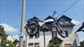 view gallery view gallery NE10.8 km NE10.8 km
|  Bike am Weiltalradweg, Weilrod, Germany Bike am Weiltalradweg, Weilrod, Germany
in Elevated Everyday Objects Ein Motorrad schwebt in der Luft *** A bike high up in the air posted by: 4spring location: Hessen, Germany date approved: 02/29/2016 last visited: 08/08/2015 |
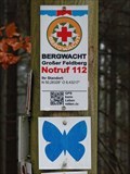 view gallery view gallery E11.7 km E11.7 km
|  N 50,28328° O 8,43217° — Schmitten, Germany N 50,28328° O 8,43217° — Schmitten, Germany
in Permanent Geographic Coordinates Coordinates and emergency number at a signpost in the forest near Seelenberg, a district of Schmitten posted by: prussel location: Hessen, Germany date approved: 01/18/2019 last visited: never |
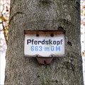 view gallery view galleryE11.7 km |  Pferdskopf — Schmitten, Germany. 663 m Pferdskopf — Schmitten, Germany. 663 m
in Elevation Signs The Pferdskopf is one of the highest mountains (662,6 m ü. NHN) in the so called Östlicher Hintertaunus posted by: prussel location: Hessen, Germany date approved: 11/26/2014 last visited: 11/07/2015 |
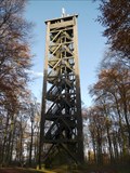 view gallery view galleryE11.7 km |  Aussichtsturm Pferdskopf — Schmitten, Germany Aussichtsturm Pferdskopf — Schmitten, Germany
in Look-Out Towers The Pferdskopf is one of the highest mountains (662,6 m ü. NHN) in the so called Eastern Hintertaunus, on the top is this 34 meter (113 ft) high wooden look-out tower posted by: prussel location: Hessen, Germany date approved: 11/06/2014 last visited: 11/07/2015 |
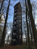 view gallery view galleryE11.7 km |  Pferdskopf Aussichtsturm, Schmitten, Germany Pferdskopf Aussichtsturm, Schmitten, Germany
in Disguised Cell Towers Innen im Turm laufen die Kabel für die oben am Turm angebrachten Mobilfunktantennen *** Inside of the wooden tower are the wires for the cell antenna at the top of the tower posted by: 4spring location: Hessen, Germany date approved: 11/13/2017 last visited: 02/04/2018 |
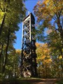 view gallery view galleryE11.7 km |  Pferdskopf Aussichtsturm, Schmitten, Germany Pferdskopf Aussichtsturm, Schmitten, Germany
in Scenic Overlooks Auf dem Berg Pferdskopf mitten im Wald steht dieser 34 Meter hohe Turm mit vielen Treppenstufen *** At the summit of the mountain Pferdskopf is this 34 meter high tower. After many steps up the tower you will have a good view posted by: 4spring location: Hessen, Germany date approved: 11/22/2017 last visited: 02/04/2018 |
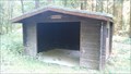 view gallery view galleryE11.7 km |  Schutzhütte Weißen Stein, Schmitten, Germany Schutzhütte Weißen Stein, Schmitten, Germany
in Remote Backcountry Shelters Beim Wegweiser "Weisser Stein" gibt es eine Schutzhütte mit gleichem Namen -- This hut is called "Weisser Stein" according to the nearby "White Stone" posted by: 4spring location: Hessen, Germany date approved: 10/08/2015 last visited: 11/04/2017 |
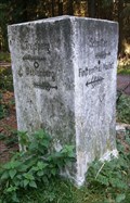 view gallery view galleryE11.7 km |  Wegweiser Weisser Stein, Schmitten, Germany Wegweiser Weisser Stein, Schmitten, Germany
in Milestones Viele Wanderwege kreuzen sich hier an diesem Wegweiser - Several hiking paths cross at this white stone showing the directions to four destinations posted by: 4spring location: Hessen, Germany date approved: 10/15/2015 last visited: 11/04/2017 |
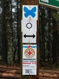 view gallery view galleryE11.7 km | N 50,27032° O 8,42952° — Schmitten, Germany in Permanent Geographic Coordinates Coordinates and emergency number at the signpost "Schutzhütte Weißer Stein" near Seelenberg, a district of Schmitten posted by: prussel location: Hessen, Germany date approved: 01/18/2019 last visited: never |
 view gallery view galleryE11.7 km |  Treisberger Bischerhäusje — Schmitten, Germany Treisberger Bischerhäusje — Schmitten, Germany
in Bookcrossing Zones The "Treisberger Bischerhäusje" is a old phone booth close to the volunteer fire brigade of the Schmitten district Treisberg posted by: prussel location: Hessen, Germany date approved: 11/04/2014 last visited: never |
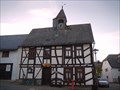 view gallery view galleryE11.9 km |  Alte Schule Treisberg — Schmitten, Germany Alte Schule Treisberg — Schmitten, Germany
in Former Schools This timber-framed building, called "Alte Schule Treisberg", served from 1860 until 1964 as the schoolhouse of the village posted by: prussel location: Hessen, Germany date approved: 11/06/2014 last visited: never |
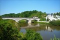 view gallery view galleryNW12.4 km |  Marmorbrücke - Villmar, Hessen, Germany Marmorbrücke - Villmar, Hessen, Germany
in Stone Bridges The Marmorbrücke in Villmar, which was built in 1894-95, is entirely made of Lahn marble. posted by: Eibacher Kuckuck location: Hessen, Germany date approved: 08/04/2014 last visited: 03/08/2015 |
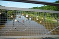 view gallery view galleryNW12.4 km |  Liebesschlösser an der Marmorbrücke - Villmar, Hessen, Germany Liebesschlösser an der Marmorbrücke - Villmar, Hessen, Germany
in Love Padlocks Am Geländer der Marmorbrücke in Villmar wurden einige Liebesschlösser befestigt | On the railing of the marble bridge in Villmar a few love padlocks have been fixed posted by: Eibacher Kuckuck location: Hessen, Germany date approved: 08/23/2014 last visited: 05/13/2015 |
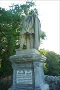 view gallery view galleryNW12.4 km |  König Konrad-Denkmal - Villmar, Hessen, Germany König Konrad-Denkmal - Villmar, Hessen, Germany
in Monarchs of the World The King Conrad monument is dedicated to the first German king Conrad I (911-918) posted by: Eibacher Kuckuck location: Hessen, Germany date approved: 08/12/2014 last visited: 04/28/2022 |
 view gallery view galleryNW12.6 km |  Marmorbruch Unica - Villmar, Hessen, Germany Marmorbruch Unica - Villmar, Hessen, Germany
in Places of Geologic Significance The Unica quarry in Villmar allows a unique three-dimensional insight into the structure of a Stromatopore reef from the Devonian posted by: Eibacher Kuckuck location: Hessen, Germany date approved: 08/04/2014 last visited: 03/08/2015 |
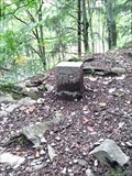 view gallery view gallery SE13 km SE13 km
|  TP Zacken-Beilstein-Steig — Glashütten, Germany TP Zacken-Beilstein-Steig — Glashütten, Germany
in German Trigonometric Points Trigonometric Point at the hiking trail "Zacken-Beilstein-Steig" in the Taunus, east of Glashütten posted by: prussel location: Hessen, Germany date approved: 04/21/2020 last visited: never |
 view gallery view gallerySE13 km | N 50,23311° O 8,42125° — Glashütten, Germany in Permanent Geographic Coordinates Coordinates and emergency number at the at the crossing of several hiking trails between Oberreifenberg, a district of the municipality of Schmitten and the Glashütten district of Oberems posted by: prussel location: Hessen, Germany date approved: 04/21/2020 last visited: never |
 view gallery view gallerySE13.4 km | N 50,22987° O 8,42411° — Zacken - Glashütten, Germany in Permanent Geographic Coordinates Coordinates and emergency number at the "Zacken", a 640 m high slate elevation east of the Glashütten district of Oberems. It is a popular training ground for mountaineers with a total of 13 climbing routes posted by: prussel location: Hessen, Germany date approved: 04/21/2020 last visited: never |
|