 view gallery view gallery E0.6 km E0.6 km
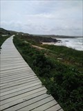
|   Godrevy walkway Godrevy Cornwall UK Godrevy walkway Godrevy Cornwall UK
in Coastal Boardwalks With Coastal erosion the original coastal path was getting very close to the edge of the cliff. A wooden walkway has been constructed to allow visitors to walk along the edge in relative safety posted by:  MoreOutdoor MoreOutdoor location: South West England, United Kingdom date approved: 05/28/2019 last visited: 05/27/2019 |
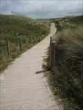 view gallery view galleryE0.8 km | Sand Dune Walkway Godrevy Cornwall UK in Coastal Boardwalks With the nearest car access (the car park) and some of the best surf in Cornwall beyond sand dunes. it is inevitable wear of the dune would quickly occur. Hence the construction of the boardwalk. posted by: MoreOutdoor location: South West England, United Kingdom date approved: 06/14/2019 last visited: 05/27/2019 |
 view gallery view galleryE0.8 km |  Southwest Coast Path- Gwithian to Godrevy Cornwall UK Southwest Coast Path- Gwithian to Godrevy Cornwall UK
in Scenic Hikes A 2 mile circular route around the Godrevy headland. posted by: MoreOutdoor location: South West England, United Kingdom date approved: 06/15/2019 last visited: 05/27/2019 |
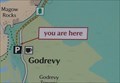 view gallery view galleryE0.8 km |  Godrevy, Cornwall UK Godrevy, Cornwall UK
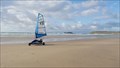
in 'You Are Here' Maps Within the entrance car park at Godrevy there is a "Welcome" map showing where you are and what trails are around. posted by: MoreOutdoor location: South West England, United Kingdom date approved: 05/28/2019 last visited: 05/28/2019 |
 view gallery view gallery SE0.8 km SE0.8 km
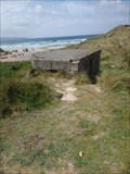
|  Disused Pill Box Godrevy Cornwall UK Disused Pill Box Godrevy Cornwall UK
in World War II Sites Situated within the sand dunes adjacent to the Red river and looking out to sea is this look out post posted by: MoreOutdoor location: South West England, United Kingdom date approved: 05/28/2019 last visited: 05/28/2019 |
 view gallery view gallery NE0.8 km NE0.8 km
|  Barrow (Cairn) Godrevy Cornwall UK Barrow (Cairn) Godrevy Cornwall UK
in Cairns A Barrow an ancient burial mound (a cairn) situated at the headland overlooking Godrevy Lighthouse.
Recent excavations and findings within the Barrow. Found artifacts were dated to around 1600BC posted by: MoreOutdoor location: South West England, United Kingdom date approved: 05/19/2019 last visited: 04/14/2019 |
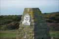
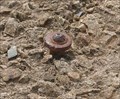 view gallery view galleryNE0.8 km |  OS bolt - Godrevy, Cornwall, UK TR27 5ED OS bolt - Godrevy, Cornwall, UK TR27 5ED
in U.K. and Ireland Trigpoints Referring to an old Ordnance Survey map (1888 - 1913). This location bolt has been recorded to be at some 149 feet above sea level posted by: MoreOutdoor location: South West England, United Kingdom date approved: 06/25/2022 last visited: 06/25/2022 |
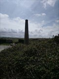
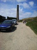 view gallery view gallerySE1 km |  Lone Chimney - Godrevy, Cornwall UK Lone Chimney - Godrevy, Cornwall UK
in Lonely Chimneys A lone Chimney on the approach to Godrevy headland posted by: MoreOutdoor location: South West England, United Kingdom date approved: 06/27/2019 last visited: 06/27/2019 |
 view gallery view gallerySE1 km |  North Cliff Mine Godrevy Cornwall UK North Cliff Mine Godrevy Cornwall UK
in Mines All that remains of the mining within this area, the North Cliff Mine workings. posted by: MoreOutdoor location: South West England, United Kingdom date approved: 06/26/2019 last visited: 06/27/2019 |
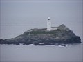 view gallery view gallery N1 km N1 km
|  Godrevy Lighthouse Godrevy Lighthouse
in Coastal Lighthouses Godrevy Lighthouse posted by:  windrush windrush location: United Kingdom date approved: 10/22/2007 last visited: 04/12/2015 |
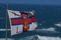 view gallery view gallery S1.1 km S1.1 km
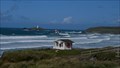
|  Royal National Lifeboat Institution Life guards hut Gwithian Beach Cornwall UK Royal National Lifeboat Institution Life guards hut Gwithian Beach Cornwall UK
in Flags of Organizations Royal National Lifeboat Institution (RNLI), protecting people on water. The local Beach lifeguard patrols the beaches to help keep everyone safe. posted by: MoreOutdoor location: South West England, United Kingdom date approved: 05/30/2019 last visited: 05/28/2019 |
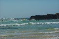 view gallery view galleryS1.1 km |  St Ives Bay Cornwall, Godrevy lighthouse St Ives Bay Cornwall, Godrevy lighthouse
in Wavy Places 3 miles of golden sands and great surf posted by: MoreOutdoor location: South West England, United Kingdom date approved: 04/12/2015 last visited: 04/19/2015 |
 view gallery view galleryS1.3 km |  St Ives Bay_ Cornwall, Uk St Ives Bay_ Cornwall, Uk
in Beaches Gwithian an access point to the St Ives Bay, over 3 miles of golden sands and some of the best surf in England. posted by: MoreOutdoor location: South West England, United Kingdom date approved: 07/21/2019 last visited: 07/21/2019 |
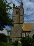 view gallery view gallerySE1.6 km |  The Church of St Gothian, Gwithian, Cornwall The Church of St Gothian, Gwithian, Cornwall
in This Old Church St Gothians Church is set the middle of the quiet village of Gwithian in West Cornwall. posted by: Sir Lose-a-lot location: South West England, United Kingdom date approved: 06/29/2011 last visited: 11/20/2016 |
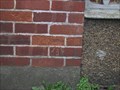
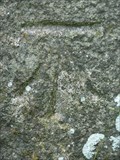 view gallery view gallerySE1.6 km | CBM- Gwithian Church, Cornwall in U.K. and Ireland Trigpoints Cut Benchmark on church tower. The CBM is on right hand side of west door. posted by: Sir Lose-a-lot location: South West England, United Kingdom date approved: 06/29/2011 last visited: 06/29/2011 |
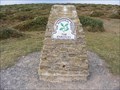 view gallery view galleryNE1.8 km | Knavocks Trigpoint in U.K. and Ireland Trigpoints Knavocks Trigpoint posted by: windrush location: United Kingdom date approved: 10/22/2007 last visited: 03/02/2012 |
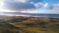
 view gallery view galleryE1.9 km |  The Knavocks The Knavocks
in National Trust U.K. The Knavocks is situated on the North Coast of Cornwall, posted by: MoreOutdoor location: South West England, United Kingdom date approved: 03/14/2012 last visited: 04/11/2015 |
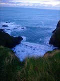
 view gallery view galleryE2.7 km |  Hell's Mouth Hell's Mouth
in Geological Devilish Locations Hell's Mouth
An Onerous name for a craggy cove on the North Cornish Coast oddly situated next to "Deadman's Cove.
This craggy cove has some very chequed history. From the ship wreck, which could be seen at certain tides. To the Tragic lose of life. posted by: MoreOutdoor location: South West England, United Kingdom date approved: 12/21/2019 last visited: 12/21/2019 |
 view gallery view galleryE2.7 km |  MV Cecil Japan, Hell's Mouth Godreve, Cornwall, UK MV Cecil Japan, Hell's Mouth Godreve, Cornwall, UK
in Shipwrecks On the 12th of March 1989, the Secil Japan was enroute from Aveiro to Liverpool when her steering collapsed of the North Cornish Coast and finally running aground at "Hell's Mouth" posted by: MoreOutdoor location: South West England, United Kingdom date approved: 02/19/2020 last visited: 02/16/2020 |
 view gallery view galleryE2.7 km | Hell's Mouth, North Cornwall, UK in National Trust U.K. Hell's Mouth on the north Cornwall coast a shear cliff face close to the coastal path and public highway, with sea views. posted by: MoreOutdoor location: South West England, United Kingdom date approved: 01/07/2020 last visited: 01/05/2020 |
 view gallery view galleryS2.9 km |  National Explosives works - Cornwall, UK National Explosives works - Cornwall, UK
in World War I Sites Explosive production - During the First World War, 1800 people were employed and the works supplied cordite to the Royal Navy. posted by: MoreOutdoor location: South West England, United Kingdom date approved: 03/19/2022 last visited: 01/11/2022 |
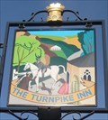 view gallery view gallerySE3.7 km |  Turnpike Inn - Connor Down, Cornwall, UK Turnpike Inn - Connor Down, Cornwall, UK
in Pictorial Pub Signs An old Coaching house within the small village of Connor Down. Set on the main road known as Turnpike Road posted by: MoreOutdoor location: South West England, United Kingdom date approved: 07/18/2022 last visited: 07/18/2022 |
 view gallery view galleryS4 km |  Hayle McDonald's - Hayle, England Hayle McDonald's - Hayle, England
in McDonald's Restaurants A MacDonalds cafe near Hayle. posted by: rjm1 location: South West England, United Kingdom date approved: 09/18/2010 last visited: never |
 view gallery view galleryS4.3 km | 60 Hollows Terrace, Copperhouse, Cornwall - Cut Bench Mark in U.K. and Ireland Trigpoints A cut Bench Mark in West Cornwall posted by: Grimspound and Jem location: United Kingdom date approved: 02/20/2008 last visited: never |
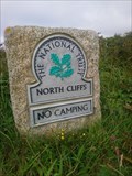 view gallery view galleryE4.7 km | North Cliff- B3301, Camborne Cornwall UK in National Trust U.K. North Cliff, a stretch of cliffs between Portreath and Gwithian Cornwall. Standing some 80 meters above the sea level, offering some spectacular coast views. posted by: MoreOutdoor location: South West England, United Kingdom date approved: 07/27/2019 last visited: 07/27/2019 |
|