 view gallery view gallery NW10.5 km NW10.5 km
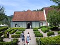
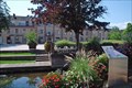
|   Musée Lalique - Wingen-sur-Moder (Alsace), France Musée Lalique - Wingen-sur-Moder (Alsace), France
in Art Museums [FR] Le musée Lalique est consacré au maître verrier et bijoutier René Lalique et à ses successeurs. [EN] The Lalique Museum is situated in the village where René Lalique founded his factory in 1921. posted by:  RakeInTheCache RakeInTheCache location: Grand-Est, France date approved: 06/11/2017 last visited: 07/23/2023 |
 view gallery view gallery S11.4 km S11.4 km
|  Aire de Lienbach - A4 - Gottesheim, France Aire de Lienbach - A4 - Gottesheim, France
in Highway Rest Areas [EN] Rest area on the A4 motorway towards Strasbourg. [FR] Aire de repos sur l'autoroute A4 en direction de Strasbourg. posted by: pmaupin location: Grand-Est, France date approved: 06/23/2024 last visited: never |
 view gallery view galleryS11.4 km |  Vous Êtes Ici : Aire de Lienbach - A4 - Gottesheim, France Vous Êtes Ici : Aire de Lienbach - A4 - Gottesheim, France
in 'You Are Here' Maps [EN] The indications "you are here" are on a sign on the Rest Area of ??Lienbach. [FR] Les indications "vous êtes ici" se trouve sur un panneau sur l'Aire de repos de Lienbach. posted by: pmaupin location: Grand-Est, France date approved: 06/22/2024 last visited: never |
 view gallery view gallery N12.9 km N12.9 km
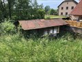
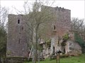
|  Château du Ramstein - Baerental/France Château du Ramstein - Baerental/France
in Castles Small medival castle build on red sand stone. posted by:  KaPsTeam KaPsTeam location: Grand-Est, France date approved: 11/01/2014 last visited: 09/20/2014 |
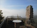 view gallery view galleryN12.9 km |  Orientation table castle Ramstein - Baerenthal/France Orientation table castle Ramstein - Baerenthal/France
in Orientation Tables Orientation table at the top of castle Ramstein. posted by: KaPsTeam location: Grand-Est, France date approved: 11/02/2014 last visited: 09/20/2014 |
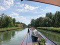
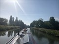
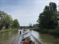 view gallery view galleryS13 km |  Écluse 36 (Rhine slope) - Canal de la Marne au Rhin (eastern section) - Steinbourg - France Écluse 36 (Rhine slope) - Canal de la Marne au Rhin (eastern section) - Steinbourg - France
in Waterway Locks, Planes and Lifts This is lock number 36 on the Rhine slope of the Canal de la Marne au Rhin (eastern section). posted by: ntpayne location: Grand-Est, France date approved: 08/08/2022 last visited: never |
 view gallery view galleryS13.2 km | ") Lavoir de Dettwiller - Bas-Rhin (67) - France Lavoir de Dettwiller - Bas-Rhin (67) - France
in Lavoir (wash houses) A lavoir in Dettwiller, Bas-Rhin (67), France. posted by: ntpayne location: Grand-Est, France date approved: 07/30/2022 last visited: never |
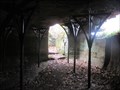
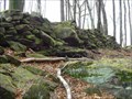
 view gallery view gallery SW13.4 km SW13.4 km
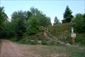
|  Oppidum de la Heidenstadt Oppidum de la Heidenstadt
in In Search of the Celts [FR] Près de Saint-Jean-Saverne, sur les hauteurs dominant la plaine d'Alsace, sont visibles les vestiges d'un oppidum celtique.
[ENG] The vestiges of a celtic oppidum are located close to the town of Saint-Jean-Saverne. posted by: Chris777 location: Grand-Est, France date approved: 05/02/2007 last visited: 10/21/2010 |
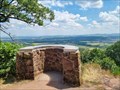 view gallery view gallerySW13.7 km | Table d'orientation du Mont Saint Michel - Saint-Jean-Saverne - France in Orientation Tables [FR] Table semi-circulaire d'orientation sur la plaine alsacienne et la ville de Saverne. [EN] Semicircular table overlooking the Alsace plain and the town of Saverne. posted by: PaulLassiter location: Grand-Est, France date approved: 07/21/2023 last visited: never |
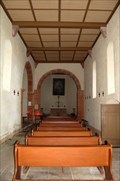 view gallery view gallerySW13.7 km |  Chapelle St Michel Chapelle St Michel
in Medieval Churches [FR]Une petite chapelle située sur le Mont St Michel près de Saverne.
[ENG] A small chapel located on the Mont St Michel close to Saverne. posted by: Chris777 location: Grand-Est, France date approved: 05/02/2007 last visited: 06/11/2023 |
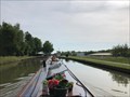
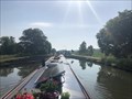
 view gallery view gallerySW13.8 km | Écluse 35 (Rhine slope) - Canal de la Marne au Rhin (eastern section) - Steinbourg - France in Waterway Locks, Planes and Lifts This is lock number 35 on the Rhine slope of the Canal de la Marne au Rhin (eastern section). posted by: ntpayne location: Grand-Est, France date approved: 08/08/2022 last visited: never |
 view gallery view galleryS13.8 km | Écluse 37 (Rhine slope) - Canal de la Marne au Rhin (eastern section) - Dettwiller - France in Waterway Locks, Planes and Lifts This is lock number 37 on the Rhine slope of the Canal de la Marne au Rhin (eastern section). posted by: ntpayne location: Grand-Est, France date approved: 08/09/2022 last visited: never |
 view gallery view gallerySW14 km |  Abbatiale Saint-Jean-Baptiste - Saint-Jean-Saverne - France Abbatiale Saint-Jean-Baptiste - Saint-Jean-Saverne - France
in Wikipedia Entries [FR] Eglise paroissiale romane, anciennement abbatiale, du XIIe siècle. [EN] [FR] Romanesque parish church, formerly an abbey church, dating from the 12th century. posted by: PaulLassiter location: Grand-Est, France date approved: 07/15/2023 last visited: never |
 view gallery view gallery NE14 km NE14 km
| Château du Wasenbourg - Niederbronn Les Bains - France in Wikipedia Entries The Wasenburg is a medieval castle in Alsace. posted by: KaPsTeam location: Grand-Est, France date approved: 11/09/2014 last visited: 05/25/2024 |
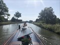
 view gallery view gallerySW14 km | Écluse 34 (Rhine slope) - Canal de la Marne au Rhin (eastern section) - Steinbourg - France in Waterway Locks, Planes and Lifts This is lock number 34 on the Rhine slope of the Canal de la Marne au Rhin (eastern section). posted by: ntpayne location: Grand-Est, France date approved: 08/08/2022 last visited: never |
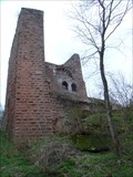 view gallery view galleryNE14 km |  Ruines du château de Wasenbourg - Niederbronn Les Bains - France Ruines du château de Wasenbourg - Niederbronn Les Bains - France
in Monuments Historiques Français The Wasenburg is a medieval castle in Alsace. posted by: KaPsTeam location: Grand-Est, France date approved: 11/11/2014 last visited: 05/25/2024 |
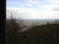 view gallery view galleryNE14 km |  View from castle Wasenbourg - Niederbronn Les Bains - France View from castle Wasenbourg - Niederbronn Les Bains - France
in Scenic Overlooks View from castle Wasenbourg. posted by: KaPsTeam location: Grand-Est, France date approved: 11/09/2014 last visited: 05/25/2024 |
 view gallery view galleryNE14 km | Château du Wasenbourg - Niederbronn Les Bains - France in Castles The Wasenburg is a medieval castle in Alsace. posted by: KaPsTeam location: Grand-Est, France date approved: 11/09/2014 last visited: 05/25/2024 |
 view gallery view galleryS14.3 km | Écluse 38 (Rhine slope) - Canal de la Marne au Rhin (eastern section) - Lupstein - France in Waterway Locks, Planes and Lifts This is lock number 38 on the Rhine slope of the Canal de la Marne au Rhin (eastern section). posted by: ntpayne location: Grand-Est, France date approved: 08/10/2022 last visited: never |
 view gallery view galleryS14.5 km | Écluse 39 (Rhine slope) - Canal de la Marne au Rhin (eastern section) - Lupstein - France in Waterway Locks, Planes and Lifts This is lock number 39 on the Rhine slope of the Canal de la Marne au Rhin (eastern section). posted by: ntpayne location: Grand-Est, France date approved: 08/10/2022 last visited: never |
 view gallery view galleryS14.6 km | Écluse 40 (Rhine slope) - Canal de la Marne au Rhin (eastern section) - Lupstein - France in Waterway Locks, Planes and Lifts This is lock number 40 on the Rhine slope of the Canal de la Marne au Rhin (eastern section). posted by: ntpayne location: Grand-Est, France date approved: 08/10/2022 last visited: never |
 view gallery view galleryNE14.8 km |  Les thermes romains - Niederbronn-Les-Bains, France Les thermes romains - Niederbronn-Les-Bains, France
in Ancient Roman Civilization [FR] Panneau présentant l'emplacement originel des thermes romains de Niederbronn-Les-Bains et décrivant les découvertes archéologiques.
[ENG] Panel giving some informations about the location of the original Roman baths of Niederbron-Les-Bains. posted by: Chris777 location: Grand-Est, France date approved: 09/14/2008 last visited: never |
 view gallery view galleryNE14.8 km | ") Les thermes romains - Niederbronn-Les-Bains, Bas-Rhin Les thermes romains - Niederbronn-Les-Bains, Bas-Rhin
in Histoires de France (French historical markers) Panneau présentant l'emplacement originel des thermes romains de Niederbronn-Les-Bains et décrivant les découvertes archéologiques. posted by: Chris777 location: Grand-Est, France date approved: 09/14/2008 last visited: never |
 view gallery view galleryNE14.8 km | Industries au 17e s. - Niederbronn-les-Bains, Bas-Rhin in Histoires de France (French historical markers) Panneau décrivant l'essor industriel de Niederbronn-les-Bains et de ses environs au XVIIe s. posted by: Chris777 location: Grand-Est, France date approved: 09/14/2008 last visited: 09/29/2013 |
 view gallery view galleryNE14.8 km | Camp Celtic - Niederbronn les Bains/France in In Search of the Celts Traces of Celtic settlement on mountain Zeigenberg. posted by: KaPsTeam location: Grand-Est, France date approved: 12/07/2014 last visited: never |
|