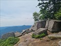
 view gallery view gallery NE2.4 km NE2.4 km
|   Vue du Rocher de Mutzig - Lutzelhouse - France Vue du Rocher de Mutzig - Lutzelhouse - France
in Scenic Overlooks [FR] Vue sur la vallée de la Bruche et les sommets environnants depuis le Rocher de Mutzig. [EN] View of the Bruche valley and the surrounding peaks from the Rocher de Mutzig. posted by:  PaulLassiter PaulLassiter location: Grand-Est, France date approved: 08/13/2023 last visited: never |
 view gallery view galleryNE2.4 km |  Rocher de Mutzig - Lutzelhouse - France Rocher de Mutzig - Lutzelhouse - France
in Wikipedia Entries [FR] Sommet gréseux du massif des Vosges. [EN] A sandstone summit in the Vosges massif. posted by: PaulLassiter location: Grand-Est, France date approved: 08/12/2023 last visited: never |
 view gallery view galleryNE2.4 km |  Rocher de Mutzig - Lutzelhouse - France Rocher de Mutzig - Lutzelhouse - France
in Mountain Summits [FR] Sommet gréseux du massif des Vosges. [EN] A sandstone summit in the Vosges massif. posted by: PaulLassiter location: Grand-Est, France date approved: 08/11/2023 last visited: never |
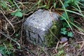
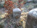 view gallery view gallery NW2.7 km NW2.7 km
|  La Baraque Carrée (740m) La Baraque Carrée (740m)
in French Benchmarks Repère de nivellement cylindrique orange posted by: Pat5488 location: Grand-Est, France date approved: 12/27/2008 last visited: never |
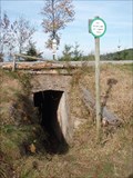 view gallery view gallery W4 km W4 km
| Le Col de l'Engin (790m) in French Benchmarks Repere cylindrique au-dessus de l'entrée du Bunker B9 qui passe sous la route. Bunker B9 sur le sentier des Bunkers au départ du Col du Donon. posted by: Pat5488 location: Grand-Est, France date approved: 10/23/2008 last visited: never |
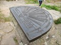 view gallery view gallery SW4.7 km SW4.7 km
|  Breite 48°30´49" Länge 24°49´55" Orientation table - Donon - Alsace/France Breite 48°30´49" Länge 24°49´55" Orientation table - Donon - Alsace/France
in Permanent Geographic Coordinates Permanent Geographic Coordinates on the orientation table at the summit of the mountain Donon. posted by:  KaPsTeam KaPsTeam location: Grand-Est, France date approved: 10/06/2014 last visited: 06/17/2023 |
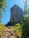
 view gallery view gallerySW4.7 km | Le Donon - Alsace/France in Mountain Summits The Donon is a mountain in the Vosges in Alsace, France. posted by: KaPsTeam location: Grand-Est, France date approved: 10/06/2014 last visited: 06/17/2023 |
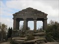 view gallery view gallerySW4.7 km |  Donon - Alsace/France Donon - Alsace/France
in Official Local Tourism Attractions The Donon is a mountain in the Vosges in Alsace, France. posted by: KaPsTeam location: Grand-Est, France date approved: 10/05/2014 last visited: 06/17/2023 |
 view gallery view gallerySW4.7 km | Le Donon - Alsace/France in Wikipedia Entries The Donon is a mountain in the Vosges in Alsace, France. posted by: KaPsTeam location: Grand-Est, France date approved: 10/04/2014 last visited: 06/17/2023 |
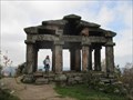
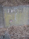
 view gallery view gallerySW4.7 km | Le Temple du Donon in French Benchmarks Au sommet de la montagne à 1000m d'altitude,un site Géodésique fort intéressant. Il y de nombreux repères à découvrir, je suis loin de les avoir tous trouvés. posted by: Pat5488 location: Grand-Est, France date approved: 10/19/2008 last visited: 06/17/2023 |
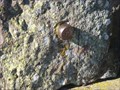 view gallery view gallerySW4.7 km |  TP bolzen-Donon-Lorraine-France TP bolzen-Donon-Lorraine-France
in European Historic Survey Stones, Monuments and Benchmarks a TP bold on the rock! Un poinçon TP dans la roche! posted by: gemeloj location: Grand-Est, France date approved: 03/09/2015 last visited: 03/18/2015 |
 view gallery view gallerySW4.7 km | View from summit of Donon - Alsace/France in Scenic Overlooks Great view from the mountain Donon. posted by: KaPsTeam location: Grand-Est, France date approved: 10/04/2014 last visited: 06/17/2023 |
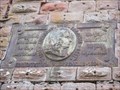
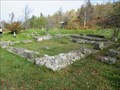 view gallery view gallerySW5 km |  Summit of Donon - Alsace/France Summit of Donon - Alsace/France
in Ancient Roman Civilization The summit of the Donon in the Vosges du Nord is marked by a historical heritage. posted by: KaPsTeam location: Grand-Est, France date approved: 10/04/2014 last visited: 06/17/2023 |
 view gallery view gallerySW5 km | Émetteur du Donon-Sarrebourg - Grandfontaine - France in Wikipedia Entries [FR] Emetteur de radio et de télévision du département Bas-Rhin et du département de la Moselle. [EN] Radio and television transmitter for the Bas-Rhin department and the Moselle department. posted by: PaulLassiter location: Grand-Est, France date approved: 10/19/2023 last visited: never |
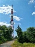 view gallery view gallerySW5 km |  Émetteur du Donon-Sarrebourg - Grandfontaine - France Émetteur du Donon-Sarrebourg - Grandfontaine - France
in Radio and Television Transmitter Towers [FR] Emetteur de radio et de télévision du département Bas-Rhin et du département de la Moselle. [EN] Radio and television transmitter for the Bas-Rhin department and the Moselle department. posted by: PaulLassiter location: Grand-Est, France date approved: 10/21/2023 last visited: never |
 view gallery view gallerySW6 km | Sentier du Donon - Alsace/France in Scenic Hikes Great hike to the summit of the mountain "Donon" posted by: KaPsTeam location: Grand-Est, France date approved: 10/05/2014 last visited: 10/11/2014 |
 view gallery view gallerySW6.1 km | Le col du Donon - La Fontaine in French Benchmarks Repère de nivellement cylindrique sur la fontaine au carrefour RD 392 et RD 993, non loin de l'auberge "le Veleda" posted by: Pat5488 location: Grand-Est, France date approved: 10/16/2008 last visited: 10/19/2008 |
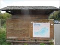
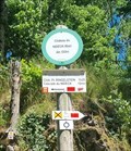
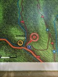 view gallery view galleryNE6.3 km |  Vous êtes ici, sur le sentier du Nideck- Oberhaslach - France Vous êtes ici, sur le sentier du Nideck- Oberhaslach - France
in 'You Are Here' Maps [FR] Description des sentiers menant à la cascade du Nideck et à ses châteaux. [EN] Description of the trails leading to the Nideck waterfall and its castles. posted by: PaulLassiter location: Grand-Est, France date approved: 08/04/2023 last visited: never |
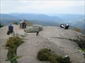
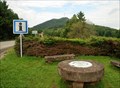 view gallery view gallerySW6.3 km |  Plate-forme du Donon - Col du Donon, France Plate-forme du Donon - Col du Donon, France
in Orientation Tables [FR] Table d'orientation située au Col du Donon, face au sommet du Donon.
[ENG] Orientation table located at the Donon pass, in front of the Donon summit. posted by: Chris777 location: Grand-Est, France date approved: 08/24/2008 last visited: 10/11/2014 |
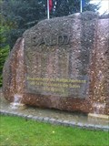 view gallery view gallery S6.6 km S6.6 km
|  Défunte Principauté de Salm (La Brocque) (Alsace) Défunte Principauté de Salm (La Brocque) (Alsace)
in Community Commemoration Un petit monument pour commémorer les 200 ans du rattachement de la Principauté de Salm à la France. posted by: gemeloj location: Grand-Est, France date approved: 02/09/2013 last visited: 02/09/2013 |
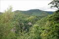 view gallery view galleryNE6.9 km | Rocher du Hirschfels - Forêt de Haslach, France in Scenic Overlooks [FR] Depuis le rocher du Hirschfels, la vue sur la vallée du Nideck et les sommets environnants est splendide.
[ENG] From the rock of Hirschfels, the view over Nideck valley and surrounding summits is splendid. posted by: Chris777 location: Grand-Est, France date approved: 09/21/2008 last visited: never |
 view gallery view galleryNE6.9 km | Crête du Hirschfels - Lieu-dit Schieferber, Bas-Rhin in French Benchmarks Borne IGN en granit placée en bout d'une crête, dans le secteur du Nideck. posted by: Chris777 location: Grand-Est, France date approved: 10/05/2008 last visited: never |
 view gallery view galleryNE6.9 km | Château du Nideck - Oberhaslach - France in Wikipedia Entries [FR] Ruines d'un ancien château fort du XIIe et XIIIe siècles. [EN] Ruins of an ancient fortified castle dating from the 12th and 13th centuries. posted by: PaulLassiter location: Grand-Est, France date approved: 08/08/2023 last visited: never |
 view gallery view galleryNE6.9 km |  Château du Nideck (bas) - Oberhaslach - France, 533 m Château du Nideck (bas) - Oberhaslach - France, 533 m
in Elevation Signs [FR] Signal d'altitude devant le donjon carré du deuxième château bas du Nideck. [EN] Altitude signal in front of the square keep of the second lower castle of Nideck. posted by: PaulLassiter location: Grand-Est, France date approved: 08/09/2023 last visited: never |
 view gallery view galleryNE6.9 km |  La Fille du géant (Das Riesenspielzeug) Giant Toy - France La Fille du géant (Das Riesenspielzeug) Giant Toy - France
in Urban Legends and Superstitions Nideck castle is known in the German-speaking world, especially through the 1816 handed down by the Brothers Grimm tale of the giant toy that inspired Adelbert von Chamisso to the poem The giant toy. posted by: KaPsTeam location: Grand-Est, France date approved: 11/08/2014 last visited: 06/13/2023 |
|