 view gallery view gallery SW4.2 km SW4.2 km
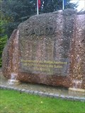
|   Défunte Principauté de Salm (La Brocque) (Alsace) Défunte Principauté de Salm (La Brocque) (Alsace)
in Community Commemoration Un petit monument pour commémorer les 200 ans du rattachement de la Principauté de Salm à la France. posted by:  gemeloj gemeloj location: Grand-Est, France date approved: 02/09/2013 last visited: 02/09/2013 |
 view gallery view gallery S4.7 km S4.7 km
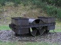
|  Le rouleau compresseur de Schirmeck ( Alsace) Le rouleau compresseur de Schirmeck ( Alsace)
in Last of its Kind Rouleau-compresseur pour l’aplanissement des routes, mu par traction humaine et utilisé au camp. posted by: gemeloj location: Grand-Est, France date approved: 12/01/2012 last visited: 12/06/2012 |
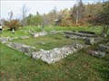
 view gallery view galleryS4.7 km |  Konzentrationslager Natzweiler-Struthof - Alsace, France Konzentrationslager Natzweiler-Struthof - Alsace, France
in WWII Prisoner of War Camps KZ Natzweiler-Struthof was a German concentration and extermination camp in Alsace. posted by:  ArktiS ArktiS location: Grand-Est, France date approved: 08/19/2009 last visited: 09/03/2015 |
 view gallery view gallery NE6 km NE6 km
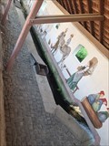
| ") Le Lavoir et sa fresque - Urmatt - France Le Lavoir et sa fresque - Urmatt - France
in Lavoir (wash houses) [FR] Reconstitution d’un lavoir à l’ancienne commandé par la mairie d’Urmatt en 2020 et orné d'une fresque. [EN] Reconstruction of an old washhouse commissioned by the town hall of Urmatt in 2020 and decorated with a fresco. posted by: PaulLassiter location: Grand-Est, France date approved: 08/10/2023 last visited: never |
 view gallery view gallery N6.3 km N6.3 km
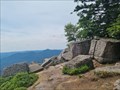
|  Vue du Rocher de Mutzig - Lutzelhouse - France Vue du Rocher de Mutzig - Lutzelhouse - France
in Scenic Overlooks [FR] Vue sur la vallée de la Bruche et les sommets environnants depuis le Rocher de Mutzig. [EN] View of the Bruche valley and the surrounding peaks from the Rocher de Mutzig. posted by: PaulLassiter location: Grand-Est, France date approved: 08/13/2023 last visited: never |
 view gallery view galleryN6.3 km |  Rocher de Mutzig - Lutzelhouse - France Rocher de Mutzig - Lutzelhouse - France
in Wikipedia Entries [FR] Sommet gréseux du massif des Vosges. [EN] A sandstone summit in the Vosges massif. posted by: PaulLassiter location: Grand-Est, France date approved: 08/12/2023 last visited: never |
 view gallery view galleryN6.3 km |  Rocher de Mutzig - Lutzelhouse - France Rocher de Mutzig - Lutzelhouse - France
in Mountain Summits [FR] Sommet gréseux du massif des Vosges. [EN] A sandstone summit in the Vosges massif. posted by: PaulLassiter location: Grand-Est, France date approved: 08/11/2023 last visited: never |
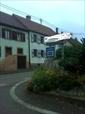 view gallery view gallerySW6.3 km |  La Brocque (Alsace) La Brocque (Alsace)
in Free Overnight RV Parking Locations Un endroit pour y dormir avec son ''camper'' au stade de la Suchette, ici posted by: gemeloj location: Grand-Est, France date approved: 10/15/2012 last visited: 12/06/2012 |
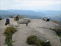
 view gallery view gallery W7.2 km W7.2 km
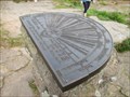
|  Breite 48°30´49" Länge 24°49´55" Orientation table - Donon - Alsace/France Breite 48°30´49" Länge 24°49´55" Orientation table - Donon - Alsace/France
in Permanent Geographic Coordinates Permanent Geographic Coordinates on the orientation table at the summit of the mountain Donon. posted by:  KaPsTeam KaPsTeam location: Grand-Est, France date approved: 10/06/2014 last visited: 06/17/2023 |
 view gallery view galleryW7.2 km | Le Donon - Alsace/France in Mountain Summits The Donon is a mountain in the Vosges in Alsace, France. posted by: KaPsTeam location: Grand-Est, France date approved: 10/06/2014 last visited: 06/17/2023 |
 view gallery view galleryW7.2 km |  Donon - Alsace/France Donon - Alsace/France
in Official Local Tourism Attractions The Donon is a mountain in the Vosges in Alsace, France. posted by: KaPsTeam location: Grand-Est, France date approved: 10/05/2014 last visited: 06/17/2023 |
 view gallery view galleryW7.2 km | Le Donon - Alsace/France in Wikipedia Entries The Donon is a mountain in the Vosges in Alsace, France. posted by: KaPsTeam location: Grand-Est, France date approved: 10/04/2014 last visited: 06/17/2023 |
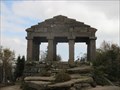
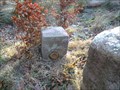
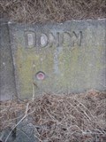
 view gallery view galleryW7.4 km |  Le Temple du Donon Le Temple du Donon
in French Benchmarks Au sommet de la montagne à 1000m d'altitude,un site Géodésique fort intéressant. Il y de nombreux repères à découvrir, je suis loin de les avoir tous trouvés. posted by: Pat5488 location: Grand-Est, France date approved: 10/19/2008 last visited: 06/17/2023 |
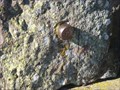 view gallery view galleryW7.4 km |  TP bolzen-Donon-Lorraine-France TP bolzen-Donon-Lorraine-France
in European Historic Survey Stones, Monuments and Benchmarks a TP bold on the rock! Un poinçon TP dans la roche! posted by: gemeloj location: Grand-Est, France date approved: 03/09/2015 last visited: 03/18/2015 |
 view gallery view galleryW7.4 km | View from summit of Donon - Alsace/France in Scenic Overlooks Great view from the mountain Donon. posted by: KaPsTeam location: Grand-Est, France date approved: 10/04/2014 last visited: 06/17/2023 |
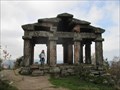
 view gallery view galleryW7.4 km |  Summit of Donon - Alsace/France Summit of Donon - Alsace/France
in Ancient Roman Civilization The summit of the Donon in the Vosges du Nord is marked by a historical heritage. posted by: KaPsTeam location: Grand-Est, France date approved: 10/04/2014 last visited: 06/17/2023 |
 view gallery view galleryW7.6 km | Émetteur du Donon-Sarrebourg - Grandfontaine - France in Wikipedia Entries [FR] Emetteur de radio et de télévision du département Bas-Rhin et du département de la Moselle. [EN] Radio and television transmitter for the Bas-Rhin department and the Moselle department. posted by: PaulLassiter location: Grand-Est, France date approved: 10/19/2023 last visited: never |
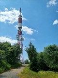 view gallery view galleryW7.6 km |  Émetteur du Donon-Sarrebourg - Grandfontaine - France Émetteur du Donon-Sarrebourg - Grandfontaine - France
in Radio and Television Transmitter Towers [FR] Emetteur de radio et de télévision du département Bas-Rhin et du département de la Moselle. [EN] Radio and television transmitter for the Bas-Rhin department and the Moselle department. posted by: PaulLassiter location: Grand-Est, France date approved: 10/21/2023 last visited: never |
 view gallery view gallery NW7.6 km NW7.6 km
| La Baraque Carrée (740m) in French Benchmarks Repère de nivellement cylindrique orange posted by: Pat5488 location: Grand-Est, France date approved: 12/27/2008 last visited: never |
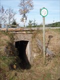 view gallery view galleryNW7.7 km | Le Col de l'Engin (790m) in French Benchmarks Repere cylindrique au-dessus de l'entrée du Bunker B9 qui passe sous la route. Bunker B9 sur le sentier des Bunkers au départ du Col du Donon. posted by: Pat5488 location: Grand-Est, France date approved: 10/23/2008 last visited: never |
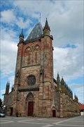 view gallery view galleryNE7.9 km | Collégiale St Florent - Niederhaslach, Bas-Rhin in French Benchmarks Repère de nivellement placé au niveau du pont enjambant la Hasel, face à la collégiale St Florent à Niederhaslach. posted by: Chris777 location: Grand-Est, France date approved: 10/05/2008 last visited: 08/13/2012 |
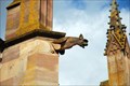 view gallery view galleryNE8 km |  Collégiale St Florent - Niederhaslach, France Collégiale St Florent - Niederhaslach, France
in Gargoyles and Chimeras [FR] La Collégiale St Florent de Niederhaslach présente de nombreuses et très belles gargouilles.
[ENG] The Collegiate Church of St Florent Niederhaslach has many beautiful gargoyles. posted by: Chris777 location: Grand-Est, France date approved: 10/11/2008 last visited: 08/13/2012 |
 view gallery view galleryW8.4 km | Sentier du Donon - Alsace/France in Scenic Hikes Great hike to the summit of the mountain "Donon" posted by: KaPsTeam location: Grand-Est, France date approved: 10/05/2014 last visited: 10/11/2014 |
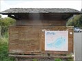
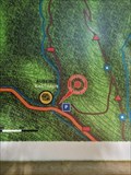 view gallery view galleryN8.5 km |  Vous êtes ici, sur le sentier du Nideck- Oberhaslach - France Vous êtes ici, sur le sentier du Nideck- Oberhaslach - France
in 'You Are Here' Maps [FR] Description des sentiers menant à la cascade du Nideck et à ses châteaux. [EN] Description of the trails leading to the Nideck waterfall and its castles. posted by: PaulLassiter location: Grand-Est, France date approved: 08/04/2023 last visited: never |
 view gallery view galleryW8.5 km | Le col du Donon - La Fontaine in French Benchmarks Repère de nivellement cylindrique sur la fontaine au carrefour RD 392 et RD 993, non loin de l'auberge "le Veleda" posted by: Pat5488 location: Grand-Est, France date approved: 10/16/2008 last visited: 10/19/2008 |
|