 view gallery view gallery NE5.6 km NE5.6 km
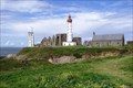
|   Phare de Saint-Mathieu - Plougonvelin, Finistère, FRA Phare de Saint-Mathieu - Plougonvelin, Finistère, FRA
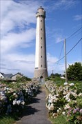
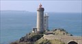
in Coastal Lighthouses The Saint-Mathieu Lighthouse is a lighthouse located on Pointe Saint-Mathieu in Plougonvelin, around Brest in Finistère. The lighthouse is open to the public. posted by:  André de Montbard André de Montbard location: Bretagne, France date approved: 11/18/2020 last visited: 12/11/2022 |
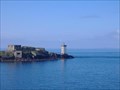 view gallery view galleryNE7.6 km | Le phare de Kermorvan in Coastal Lighthouses Le phare participe au balisage des chenaux de la Helle et du Four.
The headlight takes part in the beaconing of the channels "de la helle" and the "Four". posted by:  bob29 bob29 location: France date approved: 07/09/2007 last visited: 12/11/2022 |
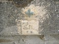 view gallery view galleryNE7.6 km |  La SNSM du Conquet. La SNSM du Conquet.
in French Benchmarks Repère de nivellement original pour hommage aux sauveteurs de la mer. posted by: bob29 location: France date approved: 09/04/2008 last visited: never |
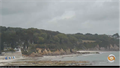
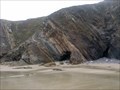
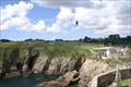 view gallery view galleryNE10.8 km |  Fort de Bertheaume - Plougonvelin, Finistère, FRA Fort de Bertheaume - Plougonvelin, Finistère, FRA
in Zip-line Two ziplines crossing the narrow gorge between the coast and the islandfortress of Fort de Bertheaume. posted by: André de Montbard location: Bretagne, France date approved: 11/29/2020 last visited: never |
 view gallery view galleryNE10.9 km |  Webcam Vue sur la plage - Plougonvelin, France Webcam Vue sur la plage - Plougonvelin, France
in Web Cameras [EN] Webcam broadcasting live images, located on the roof of the tourist office of Plougonvelin.
[FR] Webcam diffusant des images en direct, située sur le toit de l'office de tourisme de Plougonvelin. posted by: pmaupin location: Bretagne, France date approved: 06/07/2017 last visited: never |
 view gallery view gallery N13 km N13 km
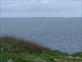
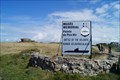
|  Pointe de Corsen - Plouarzel, France Pointe de Corsen - Plouarzel, France
in Wikipedia Entries FR - La pointe de Corsen est un cap situé sur la commune de Plouarzel, dans le Finistère.
EN - Pointe de Corsen is a cape located in the town of Plouarzel, in Finistère. posted by: geotrouvtou59 location: Bretagne, France date approved: 05/09/2023 last visited: 05/10/2023 |
 view gallery view galleryN13 km |  Pointe de Corsen - Plouarzel, France Pointe de Corsen - Plouarzel, France
in Scenic Overlooks FR - La pointe de Corsen est un cap situé sur la commune de Plouarzel, dans le Finistère.
EN - Pointe de Corsen is a cape located in the town of Plouarzel, in Finistère. posted by: geotrouvtou59 location: Bretagne, France date approved: 05/09/2023 last visited: 05/10/2023 |
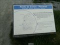
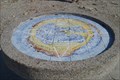
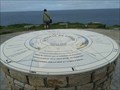 view gallery view galleryN13 km |  Table d'Orientation - La Point de Corsen - Plouarzel, France Table d'Orientation - La Point de Corsen - Plouarzel, France
in Orientation Tables FR - C'est une table d'orientation toute récente, réalisée par le Communauté de communes.
EN - This is a very recent orientation table, produced by the Community of Communes. posted by: geotrouvtou59 location: Bretagne, France date approved: 05/12/2023 last visited: 05/13/2023 |
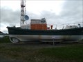 view gallery view galleryN13.2 km |  Le canot de sauvetage "Patron Aristide Lucas" - Plouarzel, France Le canot de sauvetage "Patron Aristide Lucas" - Plouarzel, France
in Lifeboats and Rescue Stations FR - LE CANOT DE SAUVETAGE "PATRON ARISTIDE LUCAS"
Station SNSM du Conquet.
EN - THE LIFEBOAT 'PATRON ARISTIDE LUCAS'
Conquet SNSM station. posted by: geotrouvtou59 location: Bretagne, France date approved: 05/06/2024 last visited: 12/01/2023 |
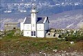
 view gallery view galleryN14.3 km | Phare de Trézien - Plouarzel, Finistère, FRA in Coastal Lighthouses The Trézien lighthouse is located inland 500 meters from the shore and 1.5 kilometers from the tip of Corsen, in the town of Plouarzel in Finistère. posted by: André de Montbard location: Bretagne, France date approved: 11/18/2020 last visited: never |
 view gallery view gallery E15.3 km E15.3 km
| Phare du Toulinguet - Camaret-sur-Mer, Finistére, FRA in Coastal Lighthouses The Toulinguet lighthouse is located at the end of the Crozon peninsula in the town of Camaret-sur-Mer in Brittany. posted by: André de Montbard location: Bretagne, France date approved: 12/26/2020 last visited: 01/22/2023 |
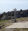
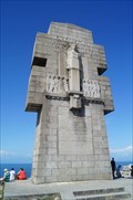 view gallery view galleryE16.1 km |  Monument aux Bretons de la France libre, dit Croix de Penhir, France Monument aux Bretons de la France libre, dit Croix de Penhir, France
in Monuments Historiques Français Le monument aux Bretons de la France libre fait l’objet d’une inscription au titre des monuments historiques depuis le 21 mai 1996.
-
The monument to the Bretons of Free France has been listed as a historical monument since May 21, 1996. posted by: André de Montbard location: Bretagne, France date approved: 11/16/2020 last visited: 06/19/2024 |
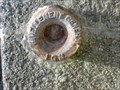
 view gallery view galleryE16.4 km | 2902202 - CAMARET-SUR-MER II, Finistère, FRA in French Benchmarks Borne en granit en Pointe de Pen Hir, Presqu'île de Crozon. posted by: André de Montbard location: Bretagne, France date approved: 09/19/2021 last visited: 01/25/2023 |
 view gallery view galleryE16.4 km | Table d'orientation de la pointe de Pen Hir (Bretagne, France) in Orientation Tables (fr) Table d'orientation située à la pointe de Pen Hir
(eng)Viewpoint located at the Pen Hir posted by: Dragon Ball location: Centre-Val-de-Loire, France date approved: 05/11/2014 last visited: 06/19/2024 |
 view gallery view galleryE16.4 km |  Coin-Op Binocular pointe de Pen Hir (Bretagne, France) Coin-Op Binocular pointe de Pen Hir (Bretagne, France)
in Coin-Op Binoculars (eng) binocular on the Pen Hir in Bretagne
(fr) binocular situé sur la pointe de Pen Hir en Bretagne posted by: Dragon Ball location: Centre-Val-de-Loire, France date approved: 05/18/2014 last visited: 06/19/2024 |
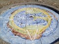
 view gallery view galleryE16.4 km |  Compass rose, Pointe de Pen Hir, Finistére, F Compass rose, Pointe de Pen Hir, Finistére, F
in Compass Roses Compass rose at the Pointe de Pen Hir, a large foreland in the bay of Douarnenez posted by: André de Montbard location: Bretagne, France date approved: 07/10/2015 last visited: 06/19/2024 |
 view gallery view galleryE16.4 km |  Musée-mémorial de la bataille de l'Atlantique - Camaret-sur-Mer, FRA Musée-mémorial de la bataille de l'Atlantique - Camaret-sur-Mer, FRA
in War and Military Museums The Battle of the Atlantic Memorial located in Camaret-sur-Mer on the site of Fort Kerbonn, in a former blockhouse dating from the Second World War. posted by: André de Montbard location: Bretagne, France date approved: 01/09/2021 last visited: 01/22/2023 |
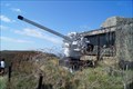 view gallery view galleryE16.4 km |  8,8 cm SK C/35 from U 766 - Point de Pen Hir, Finistére, FRA 8,8 cm SK C/35 from U 766 - Point de Pen Hir, Finistére, FRA
in Static Artillery Displays Main gun of U 766, a World War II german submarine, which surrendered 1945 at La Pallice in front of the Musée-mémorial de la bataille de l'Atlantique. posted by: André de Montbard location: Bretagne, France date approved: 12/26/2020 last visited: 01/22/2023 |
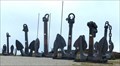 view gallery view galleryE16.4 km |  Le chemin d'ancres, Camaret sur Mer, Bretagne - France Le chemin d'ancres, Camaret sur Mer, Bretagne - France
in Anchors Le chemin d’ancres de Kerbonn est situé à la pointe de Penn Hir. Il mène au musée mémorial de la bataille de l’Atlantique / The Kerbonn anchor path is located at the tip of Penn Hir. It leads to the Battle of the Atlantic Memorial Museum posted by: GwenanDu location: Bretagne, France date approved: 03/31/2024 last visited: 06/19/2024 |
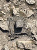
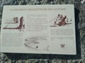
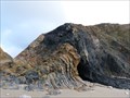 view gallery view galleryE16.7 km |  La coupe du Veryarc'h - Camaret - France La coupe du Veryarc'h - Camaret - France
in Places of Geologic Significance Les paléoenvironnements marins de l'Ordovicien au Silurien à l'observation en pied de falaise dans l'anse du Veryac'h.
The marine paleoenvironments of the Ordovician to the Silurian at the observation of foot of cliff in the cove of Veryac'h. posted by: Alfouine location: Bretagne, France date approved: 07/13/2017 last visited: 01/22/2023 |
 view gallery view galleryE16.7 km |  La coupe du Veryarc'h - Camaret - France La coupe du Veryarc'h - Camaret - France
in Paleontology and Fossils Les paléoenvironnements marins de l'Ordovicien au Silurien à l'observation en pied de falaise dans l'anse du Veryac'h.
The marine paleoenvironments of the Ordovician to the Silurian at the observation of foot of cliff in the cove of Veryac'h. posted by: Alfouine location: Bretagne, France date approved: 02/09/2020 last visited: 01/22/2023 |
 view gallery view galleryE16.7 km | La pointe du minou. in French Benchmarks D'une altitude très précise de 25,408 m ce repère en bronze se frotte tous les jours à l'air iodé de la mer d'iroise.
posted by: bob29 location: France date approved: 08/21/2008 last visited: never |
 view gallery view galleryE16.7 km | Le phare du petit minou in Coastal Lighthouses This cylindrical tower, built in 1848 on the northern coast of the narrow part of Brest, forms an alignment with the headlight of Portzic. Its height with the top of the ground is of 26 meters and with the top of the open seas of 34 meters. posted by: bob29 location: France date approved: 05/16/2007 last visited: 12/06/2022 |
 view gallery view galleryE16.7 km | Alignements de Lagatjar - Camaret-sur-Mer, France in Wikipedia Entries FR - Les alignements de Lagatjar également dénommés alignements du Toulinguet.
EN - The alignments of Lagatjar also called alignments of Toulinguet. posted by: geotrouvtou59 location: Bretagne, France date approved: 05/10/2023 last visited: 06/19/2024 |
 view gallery view galleryE16.7 km |  Alignements mégalithiques du Toulinguet- Camaret-sur-Mer, France Alignements mégalithiques du Toulinguet- Camaret-sur-Mer, France
in Satellite Imagery Oddities FR - Les alignements de Lagatjar également dénommés alignements du Toulinguet.
EN - The alignments of Lagatjar also called alignments of Toulinguet. posted by: geotrouvtou59 location: Bretagne, France date approved: 05/10/2023 last visited: 06/19/2024 |
|