 view gallery view gallery SW10.6 km SW10.6 km
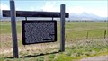
|   St. Ignatius Airport Pilots' Lounge - St. Ignatius, Montana - 3006 Feet St. Ignatius Airport Pilots' Lounge - St. Ignatius, Montana - 3006 Feet
in Elevation Signs St. Ignatius Airport is located at 900 Airport Road Street. Take the main entrance and the lounge is in a small building on the right. posted by:  T0SHEA T0SHEA location: Montana date approved: 08/31/2016 last visited: never |
 view gallery view gallery W10.6 km W10.6 km
|  Fort Connah - Charlo, MT Fort Connah - Charlo, MT
in Official Local Tourism Attractions On the east side of Highway 93, 3.3 miles south of Highway 212, which leads to Charlo, Montana, is a historical marker. Another half mile east southeast is the site of Fort Connah. posted by: T0SHEA location: Montana date approved: 06/05/2014 last visited: 07/12/2014 |
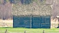 view gallery view galleryW10.6 km |  OLDEST - Building in Montana - Fort Connah, MT OLDEST - Building in Montana - Fort Connah, MT
in Superlatives On the east side of Highway 93, 3.3 miles south of Highway 212, which leads to Charlo, Montana, is a historical marker. Another half mile east southeast is the site of Fort Connah. posted by: T0SHEA location: Montana date approved: 06/05/2014 last visited: 07/12/2014 |
 view gallery view galleryW10.6 km |  Fort Connah Site - Charlo, MT Fort Connah Site - Charlo, MT
in Wikipedia Entries On the east side of Highway 93, 3.3 miles south of Highway 212, which leads to Charlo, Montana, is a historical marker. Another half mile east southeast is the site of Fort Connah. posted by: T0SHEA location: Montana date approved: 06/04/2014 last visited: 07/12/2014 |
 view gallery view galleryW10.6 km |  Fort Connah - Charlo, MT Fort Connah - Charlo, MT
in Roadside Attractions On the east side of Highway 93, 3.3 miles south of Highway 212, which leads to Charlo, Montana, is a historical marker. Another half mile east southeast is the site of Fort Connah. posted by: T0SHEA location: Montana date approved: 04/26/2019 last visited: never |
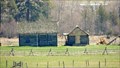 view gallery view galleryW10.6 km |  Fort Connah - Charlo, MT Fort Connah - Charlo, MT
in U.S. National Register of Historic Places On the east side of Highway 93, 3.3 miles south of Highway 212, which leads to Charlo, Montana, is a historical marker. Another half mile east southeast is the site of Fort Connah. posted by: T0SHEA location: Montana date approved: 06/05/2014 last visited: 07/12/2014 |
 view gallery view galleryW10.6 km |  Fort Connah - Charlo, Montana Fort Connah - Charlo, Montana
in Historic Forts On the east side of Highway 93, 3.3 miles south of Highway 212, which leads to Charlo, Montana, is a historical marker. Another half mile east southeast is the site of Fort Connah. posted by: T0SHEA location: Montana date approved: 06/24/2014 last visited: 06/28/2014 |
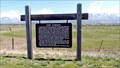 view gallery view galleryW10.6 km |  Fort Connah - Fort Connah -
in Montana Historical Markers On the east side of Highway 93, 3.3 miles south of Highway 212, which leads to Charlo, Montana, is this Historical Marker. It is about a half mile west northwest of the site of Fort Connah. posted by: T0SHEA location: Montana date approved: 06/04/2014 last visited: 06/26/2014 |
 view gallery view galleryW10.6 km |  LAST - Hudson's Bay Trading Post built in the U.S. - Charlo, MT LAST - Hudson's Bay Trading Post built in the U.S. - Charlo, MT
in Last of its Kind On the east side of Highway 93, 3.3 miles south of Highway 212, which leads to Charlo, Montana, is a historical marker. Another half mile east southeast is the site of Fort Connah. posted by: T0SHEA location: Montana date approved: 06/04/2014 last visited: 06/18/2014 |
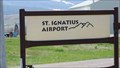 view gallery view gallerySW10.8 km |  St Ignatius Airport - St Ignatius, MT St Ignatius Airport - St Ignatius, MT
in Airports This small civil aviation airport is on Airport Road, which runs east off Highway 93, about a half mile northeast of St Ignatius. posted by: T0SHEA location: Montana date approved: 08/03/2014 last visited: never |
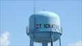 view gallery view gallerySW11.3 km |  Town of St. Ignatius Water Tower - St. Ignatius, MT Town of St. Ignatius Water Tower - St. Ignatius, MT
in Water Towers Here is a water tower in a somewhat more picturesque setting than the norm. posted by: T0SHEA location: Montana date approved: 01/02/2015 last visited: never |
 view gallery view gallerySW11.7 km |  St. Ignatius School Bell - St. Ignatius Montana St. Ignatius School Bell - St. Ignatius Montana
in Bells This bell is mounted atop a wooden tower in front of a building of the St. Ignatius School. posted by: T0SHEA location: Montana date approved: 08/04/2014 last visited: never |
 view gallery view gallerySW11.7 km |  St. Ignatius, Montana - 59865 St. Ignatius, Montana - 59865
in U.S. Post Offices The St. Ignatius Post Office is located at 120 1st Avenue. posted by: T0SHEA location: Montana date approved: 07/03/2014 last visited: never |
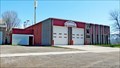
 view gallery view gallerySW11.9 km |  Community raises funds for the St. Ignatius VFD - St. Ignatius, Montana Community raises funds for the St. Ignatius VFD - St. Ignatius, Montana
in News Article Locations Sharing a building with the local constabulary, the St. Ignatius Volunteer Fire Department is on the east side of First Avenue, just north of Arrow Street. posted by: T0SHEA location: Montana date approved: 08/05/2023 last visited: never |
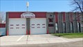 view gallery view gallerySW11.9 km |  St. Ignatius Vol. Fire Department - St. Ignatius, MT St. Ignatius Vol. Fire Department - St. Ignatius, MT
in Firehouses Sharing a building with the local constabulary, the St. Ignatius Volunteer Fire Department is on the east side of First Avenue, just north of Arrow Street. posted by: T0SHEA location: Montana date approved: 06/21/2014 last visited: never |
 view gallery view gallerySW11.9 km |  St. Ignatius Potpourri - St. Ignatius, MT St. Ignatius Potpourri - St. Ignatius, MT
in Lucky 7 This is a collection of Waymarks from around the town of St. Ignatius representing a bit of a cross section of what's to be found in the town. posted by: T0SHEA location: Montana date approved: 01/21/2019 last visited: never |
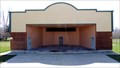 view gallery view gallerySW12.1 km |  St. Ignatius Good Old Days Park Bandshell - St. Ignatius, MT St. Ignatius Good Old Days Park Bandshell - St. Ignatius, MT
in Bandshells The Good Old Days Park in St. Ignatius is along Mountainview Drive on the western edge of town. posted by: T0SHEA location: Montana date approved: 08/04/2014 last visited: 06/11/2015 |
 view gallery view gallerySW12.1 km |  St. Ignatius Good Old Days Park Amphitheater - St. Ignatius, MT St. Ignatius Good Old Days Park Amphitheater - St. Ignatius, MT
in Outdoor Amphitheaters The Good Old Days Park in St. Ignatius is along Mountainview Drive on the western edge of town. posted by: T0SHEA location: Montana date approved: 08/04/2014 last visited: 06/11/2015 |
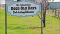 view gallery view gallerySW12.1 km |  St. Ignatius Good Old Days Park - St. Ignatius, MT St. Ignatius Good Old Days Park - St. Ignatius, MT
in Municipal Parks and Plazas The Good Old Days Park in St. Ignatius is along Mountainview Drive on the western edge of town. posted by: T0SHEA location: Montana date approved: 08/04/2014 last visited: never |
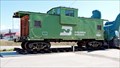 view gallery view gallerySW12.1 km |  Burlington Northern Caboose #12200 - St. Ignatius, MT Burlington Northern Caboose #12200 - St. Ignatius, MT
in Train Cabooses Along Highway 93 at St. Ignatius, on the west side is a Sinclair Station, a Trading Post & Museum, and the Huckleberry Jam Factory. posted by: T0SHEA location: Montana date approved: 08/05/2014 last visited: never |
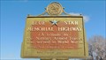 view gallery view gallery NW12.2 km NW12.2 km
|  Highway 93 - Charlo, MT Highway 93 - Charlo, MT
in Blue Star Memorial Highway Markers This Blue Star Memorial Highway marker is on the east side of Highway 93, 1.2 miles south of Highway 212, the turnoff to Charlo, Montana. posted by: T0SHEA location: Montana date approved: 04/14/2014 last visited: 07/13/2006 |
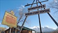
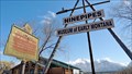 view gallery view galleryNW12.2 km |  Ninepipes Museum of Early Montana - Charlo, MT Ninepipes Museum of Early Montana - Charlo, MT
in History Museums Charlo is the nearest town to Ninepipes, which is on Highway 93, about 5 miles south of Ronan and 4 miles east of Charlo. posted by: T0SHEA location: Montana date approved: 12/18/2014 last visited: 06/21/2015 |
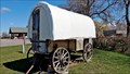 view gallery view galleryNW12.2 km |  Ninepipes Museum Wagon - Charlo, MT Ninepipes Museum Wagon - Charlo, MT
in Covered Wagons Charlo is the nearest town to the Ninepipes Museum of Early Montana, which is on Hwy. 93, about 5 miles south of Ronan and 4 miles east of Charlo. posted by: T0SHEA location: Montana date approved: 03/06/2015 last visited: 06/21/2015 |
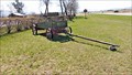 view gallery view galleryNW12.2 km |  Ninepipes Museum of Early Montana - Charlo, MT Ninepipes Museum of Early Montana - Charlo, MT
in Carriages and Coaches on Permanent Display Charlo is the nearest town to the Ninepipes Museum of Early Montana, which is on Highway 93, about 5 miles south of Ronan and 4 miles east of Charlo. posted by: T0SHEA location: Montana date approved: 12/18/2014 last visited: 06/21/2015 |
 view gallery view galleryNW12.2 km | Ninepipes Museum of Early Montana - Charlo, MT in Official Local Tourism Attractions Charlo is the nearest town to Ninepipes, which is on Highway 93, about 5 miles south of Ronan and 4 miles east of Charlo. posted by: T0SHEA location: Montana date approved: 12/18/2014 last visited: 06/21/2015 |
|