 view gallery view gallery NE5.6 km NE5.6 km
|   Mowich Mowich
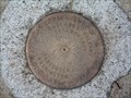
in U.S. Benchmarks A USGS Cascades Volcano Observatory marker located near the shores of Mowich Lake, at the end of WA 165, Mountain Meadows Rd. posted by:  Hop2it Hop2it location: Washington date approved: 08/30/2007 last visited: 08/27/2007 |
 view gallery view gallery E7.2 km E7.2 km
| Observation Rock in U.S. Benchmarks on top of a red volcanic lava cone on the side of Mt Rainier at an elevation of 8376 feet posted by:  TeamHenryBear TeamHenryBear location: Washington date approved: 10/29/2008 last visited: 08/04/2013 |
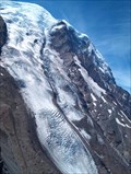
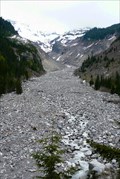
 view gallery view galleryNE10.5 km |  Carbon Glacier - Mount Rainier National Park, WA Carbon Glacier - Mount Rainier National Park, WA
in American Guide Series Carbon Glacier is located on the north slope of Mount Rainier within Mount Rainier National Park. It's snout lies at 3,500 feet above sea level and can be accessed via a 4 mile hike out of Ipsut Creek Campground. posted by: Hikenutty location: Washington date approved: 12/25/2007 last visited: 12/26/2007 |
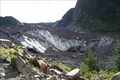 view gallery view galleryNE10.5 km |  Carbon Glacier - Mt. Rainier, WA Carbon Glacier - Mt. Rainier, WA
in Glaciers Carbon Glacier is located on the north slope of Mount Rainier within Mount Rainier National Park. It's snout lies at 3,500 feet above sea level and can be accessed via a 4 mile hike out of Ipsut Creek Campground. posted by: Hikenutty location: Washington date approved: 03/29/2008 last visited: 03/30/2008 |
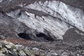 view gallery view galleryNE10.5 km |  ORIGIN - Carbon River ORIGIN - Carbon River
in River Origins, Destinations and Confluences Carbon River originates at the snout of Carbon Glacier, which is located on the north slope of Mount Rainier within Mount Rainier National Park. posted by: Hikenutty location: Washington date approved: 12/30/2007 last visited: 10/21/2021 |
 view gallery view gallery S10.6 km S10.6 km
|  Gobbler's Knob Gobbler's Knob
in Look-Out Towers Gobbler's Knob Lookout in Mt. Rainier National Park posted by: Prying Pandora location: Washington date approved: 09/08/2010 last visited: never |
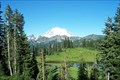
 view gallery view gallery SE10.9 km SE10.9 km
|  Mt. Rainier from the Mirror Lakes Mt. Rainier from the Mirror Lakes
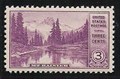
in Philatelic Photographs This is the site of the Asahel Curtis photograph that was used for the 1934 US 3c National Parks postage stamp. posted by: hykesj location: Washington date approved: 06/04/2012 last visited: 01/24/2021 |
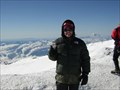 view gallery view galleryE11.3 km |  Mt. Rainier Summit, Washington's High Point Mt. Rainier Summit, Washington's High Point
in Mountain Summits Columbia Crest posted by: The Mercury Project location: Washington date approved: 09/08/2005 last visited: 07/16/2004 |
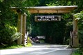
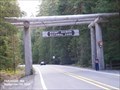 view gallery view galleryE12.2 km |  Mount Rainier National Park - Ashford WA Mount Rainier National Park - Ashford WA
in Wikipedia Entries Mount Rainier National Park-use the address 39000 State Route 706 E, Ashford, WA 98304. This will take you on SR 706 east past the Administration Building to the Nisqually Entrance. posted by: Don.Morfe location: Washington date approved: 04/14/2024 last visited: 04/14/2024 |
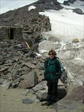 view gallery view gallerySE14 km | ") Camp Muir, Mount Rainier National Park Camp Muir, Mount Rainier National Park
in National Parks (U.S.) Camp Muir is located on the side of Mount Rainier just above the 10,000 foot level. posted by: run4cache location: Washington date approved: 07/16/2007 last visited: 10/21/2021 |
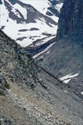
 view gallery view galleryE14.2 km | Winthrop Glacier - Mt. Rainier National Park in Glaciers Winthrop Glacier on the NE side of Mt. Rainier posted by: Prying Pandora location: Washington date approved: 09/07/2008 last visited: 07/07/2018 |
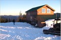 view gallery view gallery SW14.5 km SW14.5 km
|  Copper Creek Hut Copper Creek Hut
in Remote Backcountry Shelters This free hut is operated by the Mount Tahoma Trails Association, and could sleep 14 guests. posted by: gleek location: Washington date approved: 12/19/2005 last visited: never |
 view gallery view gallery NW14.5 km NW14.5 km
|  Latitude 47 Latitude 47
in Bloggers The official blog of Geocaching.com! posted by: Blue Man location: Washington date approved: 05/26/2010 last visited: 12/27/2022 |
 view gallery view gallerySE15.1 km | Christine Falls Bridge in Wikipedia Entries A historic bridge spans a historic waterfall. posted by: ChapterhouseInc location: Washington date approved: 07/07/2013 last visited: 03/05/2020 |
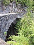 view gallery view gallerySE15.1 km |  Christine Falls Bridge - Mt Rainier National Park Christine Falls Bridge - Mt Rainier National Park
in Stone Bridges A historic bridge spans a historic waterfall. posted by: ChapterhouseInc location: Washington date approved: 07/06/2013 last visited: 03/05/2020 |
 view gallery view gallerySE15.1 km | Nisqually Glacier, Mount Rainier - Washington in American Guide Series The Nisqually Glacier is one of the many glaciers covering the flanks of Mt. Rainier, the most glaciated peak in the continental United States. posted by: Hikenutty location: Washington date approved: 05/27/2007 last visited: 10/19/2017 |
 view gallery view gallerySE15.1 km | ORIGIN - Nisqually River in River Origins, Destinations and Confluences The Nisqually river originates here at the toe of Mt. Rainier's Nisqually glacier, and it ends at the Nisqually Wildlife Preserve where it empties into the Puget Sound. posted by: Hikenutty location: Washington date approved: 05/27/2007 last visited: 08/20/2018 |
 view gallery view gallerySE15.1 km | Nisqually Glacier, Mount Rainier in Glaciers This is the most easily accessible of the many glaciers of Mt. Rainier. posted by: Hikenutty location: Washington date approved: 06/07/2007 last visited: 08/20/2018 |
 view gallery view gallerySE15.1 km | Christine Falls - Mt. Rainier National Park in American Guide Series Christine Falls and the historic Christine Falls bridge can be found past the Nisqually entrance of Mt. Rainier NP on the road up to the Paradise Visitor center and lodge. posted by: Hikenutty location: Washington date approved: 05/27/2007 last visited: 10/19/2017 |
 view gallery view gallerySE15.1 km |  Christine Falls Bridge - Mt. Rainier National Park Christine Falls Bridge - Mt. Rainier National Park
in U.S. National Register of Historic Places The historic Christine Falls bridge can be found past the Nisqually entrance of Mt. Rainier NP on the road up to the Paradise Visitor center and lodge. posted by: Hikenutty location: Washington date approved: 05/28/2007 last visited: 10/19/2017 |
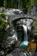 view gallery view gallerySE15.1 km |  Christine Falls - Mt. Rainier National Park Christine Falls - Mt. Rainier National Park
in Waterfalls Christine Falls can be seen on the drive from the Mt. Rainier NP Nisqually entrance up to Paradise Visitor Center. posted by: Hikenutty location: Washington date approved: 05/27/2007 last visited: 05/11/2023 |
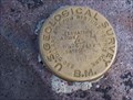
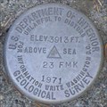 view gallery view gallerySE15.8 km | USGS 23FMK, Washington in U.S. Benchmarks USGS benchmark on Nisqually River Bridge in Mt. Rainier NP, Washington. posted by: Volcanoguy location: Washington date approved: 11/06/2006 last visited: 08/22/2010 |
 view gallery view gallerySE16.3 km |  Nisqually Vista View Point - Washington Nisqually Vista View Point - Washington
in Scenic Overlooks This view point is reached by a trail from the parking lot at Paradise Visitor Center in Mt. Rainier National Park. posted by: Volcanoguy location: Washington date approved: 11/17/2006 last visited: 06/18/2018 |
 view gallery view galleryS16.4 km | Nisqually Entrance to Paradise Valley - Mt. Rainier National Park in American Guide Series The Nisqually entrance to Mt. Rainier National Park is open year round and is the most used entrance for visitors to the park. posted by: Hikenutty location: Washington date approved: 05/27/2007 last visited: 08/20/2018 |
 view gallery view galleryS16.4 km |  Mt. Rainier National Park - U.S. National Parks Edition Mt. Rainier National Park - U.S. National Parks Edition
in Monopoly in the Real World Mt. Rainier National Park is considered one of the crown jewels of the National Park system. Its space costs $180 on the U.S. National Parks Edition Monopoly board. posted by: Hikenutty location: Washington date approved: 11/30/2007 last visited: 08/20/2018 |
|