 view gallery view gallery SW0.2 km SW0.2 km
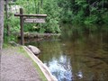
|   The Winnebojou Canoe Landing The Winnebojou Canoe Landing
in Canoe/Kayak Trips This waymark is located at the Winneboujou Canoe Landing. posted by:  Troutonthebrain Troutonthebrain location: Wisconsin date approved: 06/14/2012 last visited: 10/11/2021 |
 view gallery view gallery NE2.3 km NE2.3 km
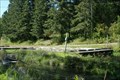
|  The Brule Fish Hatchery -- Brule, Wisconsin The Brule Fish Hatchery -- Brule, Wisconsin
in Fish Hatcheries This cache is located at the Brule State Forest Fish Hatchery. posted by: Troutonthebrain location: Wisconsin date approved: 06/05/2012 last visited: 05/28/2021 |
 view gallery view gallery N3.7 km N3.7 km
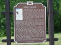
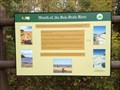
|  Brule River Brule River
in Wisconsin Historical Markers Brule River Marker in Brule. posted by:  frankhj frankhj location: Wisconsin date approved: 08/07/2008 last visited: 07/17/2017 |
 view gallery view gallery W7.6 km W7.6 km
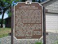
| Evergreen Park Cottage Sanatorium in Wisconsin Historical Markers Evergreen Park Cottage Sanatorium Marker in Lake Nebagamon. posted by: frankhj location: Wisconsin date approved: 08/07/2008 last visited: 10/09/2009 |
 view gallery view gallery E15.4 km E15.4 km
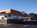
|  A&W - Iron River, Wisconsin A&W - Iron River, Wisconsin
in A + W Restaurants A&W located on Highway 2 in Iron River, WI. posted by: lenron location: Wisconsin date approved: 11/11/2010 last visited: 05/28/2021 |
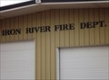 view gallery view galleryE16.1 km |  Iron River Fire Dept. Iron River Fire Dept.
in Firehouses This Firehouse is on US Highway 2 about 1400 feet east of Oneida Street nin Iron River, Wisconsin. posted by: PeterNoG location: Wisconsin date approved: 07/24/2013 last visited: 11/26/2016 |
 view gallery view gallery NW16.4 km NW16.4 km
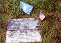
|  Richard I. Bong-Poplar WI Richard I. Bong-Poplar WI
in Medal Of Honor Resting Places World War II Medal of Honor Recipient for action in the air over Borneo and Leyte from October 10 to November 15, 1944. He is buried in Poplar Cemetery, Poplar WI in Plat 1, Block 8, Lot 10. posted by: Don.Morfe location: Wisconsin date approved: 10/09/2017 last visited: 12/19/2021 |
 view gallery view galleryNW16.9 km |  Poplar, WI 54864 Poplar, WI 54864
in U.S. Post Offices Post office in small town of Poplar, Wisconsin. posted by: lenron location: Wisconsin date approved: 11/20/2010 last visited: 06/29/2017 |
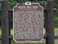
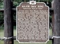 view gallery view galleryNW17.1 km |  Major "Dick" Bong "America's Ace of Aces"-Poplar, WI Major "Dick" Bong "America's Ace of Aces"-Poplar, WI
in World War II Memorials / Monuments Poplar, WI was the home town of Dick Bong. In World War II he destroyed 40 enemy aircraft in air combat and become America's leading ace of all time. He was a Medal of Honor Recipient. posted by: Don.Morfe location: Wisconsin date approved: 10/12/2017 last visited: 10/28/2021 |
 view gallery view galleryNW17.1 km | Major "Dick" Bong - "America's Ace of Aces" in Wisconsin Historical Markers Major "Dick" Bong Marker in Poplar. posted by: frankhj location: Wisconsin date approved: 08/07/2008 last visited: 06/29/2017 |
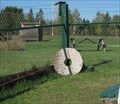
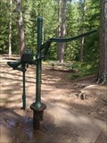 view gallery view galleryNW24.5 km |  Hand-Operated Pump at Amnicon Falls southeast of Superior, WI USA Hand-Operated Pump at Amnicon Falls southeast of Superior, WI USA
in Hand Operated Water Pumps A working hand-operated water pump at Amnicon Falls State Park in northern Wisconsin posted by: MountainWoods location: Wisconsin date approved: 07/10/2017 last visited: 07/04/2017 |
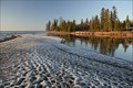 view gallery view galleryN25.6 km |  DESTINATION: Brule River - Lake Superior DESTINATION: Brule River - Lake Superior
in River Origins, Destinations and Confluences The Mouth of the Brule River. posted by: Troutonthebrain location: Wisconsin date approved: 06/13/2012 last visited: 10/12/2013 |
 view gallery view galleryN25.6 km |  Mouth of the Bois Brule River – rural Brule, WI Mouth of the Bois Brule River – rural Brule, WI
in Signs of History This historical marker is located in a picnic area at the mouth of the Brule River. posted by: wildernessmama location: Wisconsin date approved: 10/15/2013 last visited: never |
 view gallery view gallery S26.1 km S26.1 km
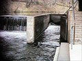
|  Eau Claire Lakes lock Eau Claire Lakes lock
in Waterway Locks, Planes and Lifts A small lock located under the bridge at Shore Road posted by: handyman4125 location: Wisconsin date approved: 08/28/2006 last visited: 08/19/2009 |
 view gallery view gallerySW27 km | Brule-St. Croix Portage in Wisconsin Historical Markers Brule-St. Croix Portage Marker S of Solon Springs. posted by: frankhj location: Wisconsin date approved: 08/07/2008 last visited: 02/25/2015 |
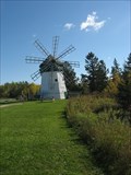 view gallery view galleryNW27.7 km |  Davidson Windmill – rural Superior, WI Davidson Windmill – rural Superior, WI
in U.S. National Register of Historic Places A sign tells a little of the history of this impressive windmill. posted by: wildernessmama location: Wisconsin date approved: 10/15/2013 last visited: 05/27/2021 |
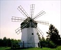 view gallery view galleryNW27.7 km |  Davidson Windmill Davidson Windmill
in Windmills Entered into the National Register of Historic Places in 1979, the Davidson Windmill is maintained for display within sight of State Highway 13 about 4 miles from US Highway 2. posted by: handyman4125 location: Wisconsin date approved: 08/29/2006 last visited: 05/27/2021 |
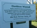 view gallery view galleryNW27.7 km | Davidson Windmill – rural Superior, WI in Signs of History A sign tells a little of the history of this impressive windmill. posted by: wildernessmama location: Wisconsin date approved: 10/15/2013 last visited: 05/27/2021 |
 view gallery view galleryNW27.7 km |  Davidson Windmill Millstones – Superior, WI Davidson Windmill Millstones – Superior, WI
in Millstones Three millstones are on display at the Davidson Windmill along Hwy. 13 east of Superior. posted by: wildernessmama location: Wisconsin date approved: 10/14/2013 last visited: 05/27/2021 |
 S28.8 km | Eau Claire River Daytripper in Canoe/Kayak Trips A local favorite for canoes, kayaks or tubes. posted by: handyman4125 location: Wisconsin date approved: 08/28/2006 last visited: never |
 view gallery view galleryNE33 km | School Consolidation in Wisconsin Historical Markers Historical marker near Port Wing posted by: Benron location: Wisconsin date approved: 03/25/2010 last visited: 05/27/2021 |
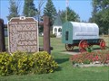
 view gallery view galleryNE33 km |  Old Town Jail – Port Wing, WI Old Town Jail – Port Wing, WI
in Retired Prisons Port Wing’s old town jail is just one of several historical displays in this little city park. posted by: wildernessmama location: Wisconsin date approved: 10/15/2013 last visited: 05/27/2021 |
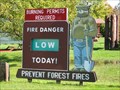 view gallery view galleryNE33 km |  Smokey Bear – Port Wing, WI Smokey Bear – Port Wing, WI
in Smokey Bear Sign Sightings Smokey Bear stands guard over Port Wing’s city park to remind people of their responsibility to prevent forest fires. posted by: wildernessmama location: Wisconsin date approved: 10/19/2013 last visited: 05/27/2021 |
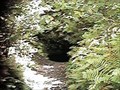 view gallery view galleryS33.2 km | ") Weyerhaeuser Mine Site Weyerhaeuser Mine Site
in Cave Entrances (Artificial) One of three shafts operated in the early 20th century. posted by: handyman4125 location: Wisconsin date approved: 08/28/2006 last visited: 08/19/2009 |
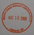 view gallery view galleryE33.6 km |  Apostle Islands NL NGLVC Ashland WI Apostle Islands NL NGLVC Ashland WI
in NPS Passport Cancellation Stations Along windswept beaches and cliffs, visitors experience where water meets land and sky, culture meets culture, and past meets present. posted by: nomadwillie location: Wisconsin date approved: 11/06/2008 last visited: 01/08/2015 |
|