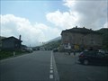
 view gallery view gallery NE6.6 km NE6.6 km
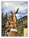
|   San (Saint) Luigi Guanella - Campodolcino, Italy San (Saint) Luigi Guanella - Campodolcino, Italy
in Statues of Religious Figures Bronze statue of Saint Luigi Guanella (1842–1915) in Campodolcino in front of "Chiesa di San Giovanni Battista (St John of Baptist Church). posted by:  vraatja vraatja location: Lombardia, Italy date approved: 10/18/2018 last visited: never |
 view gallery view gallery S16.6 km S16.6 km
|  Alpe di Mezzo - Province Como, Lombardia, Italy Alpe di Mezzo - Province Como, Lombardia, Italy
in Elevation Signs Elevation sign Alpe di Mezzo. posted by:  Tharandter Tharandter location: Lombardia, Italy date approved: 11/16/2013 last visited: 07/09/2013 |
 view gallery view gallery N17.4 km N17.4 km
|  Splügenpass - Graubünden (CH) / Lombardia (I) Splügenpass - Graubünden (CH) / Lombardia (I)
in Border Crossings Der Grenzübergang Splügenpass. The Spluegen border crossing between Switzerland and Italy. posted by: Tharandter location: Graubünden, Switzerland date approved: 10/08/2013 last visited: 10/03/2018 |
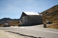
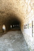 view gallery view galleryN17.9 km |  Splügengalerie - Graubünden, CH Splügengalerie - Graubünden, CH
in Official Local Tourism Attractions Die Splügengalerie auf dem Splügenpass. posted by: Tharandter location: Graubünden, Switzerland date approved: 10/07/2013 last visited: never |
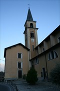
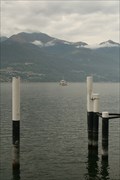
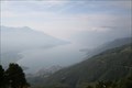 view gallery view galleryS18.2 km |  San Bartolomeo - Province Como, Lombardia, Italy San Bartolomeo - Province Como, Lombardia, Italy
in Scenic Overlooks Lake Como view from San Bartolomeo. posted by: Tharandter location: Lombardia, Italy date approved: 11/15/2013 last visited: never |
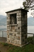
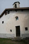 view gallery view galleryS18.2 km |  Chiesa di San Bartolomeo - Province Como, Lombardia, Italy Chiesa di San Bartolomeo - Province Como, Lombardia, Italy
in Waychapels The chapel San Bartolomeo in Sorico. posted by: Tharandter location: Lombardia, Italy date approved: 11/16/2013 last visited: never |
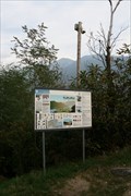 view gallery view gallery SE19.5 km SE19.5 km
|  Pian di Spagna-Lago di Mezzola - Dascio, Province Como, Lombardia, Italy Pian di Spagna-Lago di Mezzola - Dascio, Province Como, Lombardia, Italy
in Flora and Fauna Information Signs Information board of the Nature Reserve of Lake Mezzola. posted by: Tharandter location: Lombardia, Italy date approved: 11/18/2013 last visited: never |
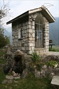 view gallery view gallerySE19.5 km | San Maria - Dascio, Province Como, Lombardia, Italy in Waychapels A little waychapel at a great view point. posted by: Tharandter location: Lombardia, Italy date approved: 11/21/2013 last visited: never |
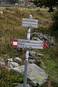
 view gallery view gallery NW19.6 km NW19.6 km
|  Passo San Bernardino, Graubünden, CH Passo San Bernardino, Graubünden, CH
in Named Mountain Gaps San Bernardino Pass (elevation 2,066 metres or 6,778 feet) is a high mountain pass in the Swiss Alps connecting the Hinterrhein and the Mesolcina (Misox) valleys between Thusis (Graubünden) and Bellinzona (Ticino). posted by: André de Montbard location: Graubünden, Switzerland date approved: 04/06/2015 last visited: 06/12/2023 |
 view gallery view galleryS21.2 km |  San Salvatore - Vercana, Province Como, Lombardia, Italy San Salvatore - Vercana, Province Como, Lombardia, Italy
in Roman Catholic Churches The parish church San Salvatore in Vercana. posted by: Tharandter location: Lombardia, Italy date approved: 10/07/2013 last visited: never |
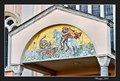 view gallery view galleryS24.3 km |  Tympanum mosaic of St George Church (Chiesa San Giorgio) - Colico, Italy Tympanum mosaic of St George Church (Chiesa San Giorgio) - Colico, Italy
in Mosaics The mosaics on a tympanum of St George Church (Chiesa San Giorgio) in Colico depicting St George fighting with a dragon. posted by: vraatja location: Lombardia, Italy date approved: 11/09/2018 last visited: never |
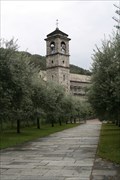 view gallery view galleryS25.3 km |  Abbazia di Piona - Colico, Province Lecco, Lombardia, Italy Abbazia di Piona - Colico, Province Lecco, Lombardia, Italy
in Abbeys, Convents and Monasteries The abbey of Piona. posted by: Tharandter location: Lombardia, Italy date approved: 01/30/2014 last visited: 07/11/2012 |
 view gallery view galleryS25.3 km |  Attracco Battello - Piona, Province Lecco, Lombardia, Italy Attracco Battello - Piona, Province Lecco, Lombardia, Italy
in Ferries and Ferry Landings The passenger ferry landing in Piona. posted by: Tharandter location: Lombardia, Italy date approved: 01/30/2014 last visited: never |
 view gallery view galleryS25.3 km |  Madonna shrine - Piona, Province Lecco, Lombardia, Italy Madonna shrine - Piona, Province Lecco, Lombardia, Italy
in Wayside shrines The wayside shrine at the ferry landing of Piona. posted by: Tharandter location: Lombardia, Italy date approved: 01/28/2014 last visited: never |
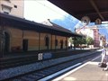 view gallery view gallery W26.2 km W26.2 km
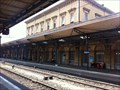
|  Biasca, TI, Switzerland Biasca, TI, Switzerland
in Train Stations/Depots The railway station of Biasca. posted by: fi67 location: Ticino, Switzerland date approved: 09/26/2013 last visited: 10/16/2016 |
 view gallery view galleryW26.2 km |  Bahnhof - Biasca, TI, Switzerland Bahnhof - Biasca, TI, Switzerland
in Austrian and Swiss National Heritage Sites The railway station of Biasca. posted by: fi67 location: Ticino, Switzerland date approved: 09/26/2013 last visited: 10/16/2016 |
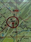
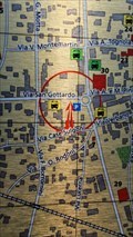 view gallery view galleryW26.7 km |  You are here circle&arrow - Biasca, Ticino, Switzerland You are here circle&arrow - Biasca, Ticino, Switzerland
in 'You Are Here' Maps In the small town center of Biasca you will find a parkinglot and the map of the city on it. posted by: T-Team! location: Ticino, Switzerland date approved: 09/01/2022 last visited: never |
 view gallery view gallery SW28 km SW28 km
| Bellinzona, TI, Switzerland in Train Stations/Depots The railway station of Bellinzona is the largest railway junction in the Italian speaking part of Switzerland. posted by: fi67 location: Ticino, Switzerland date approved: 08/16/2012 last visited: never |
 view gallery view gallerySW28 km | Train Station, Bellinzona, Switzerland in 'You Are Here' Maps A You are Here map near the train station of Bellinzona posted by: Torgut location: Ticino, Switzerland date approved: 07/15/2012 last visited: 02/15/2013 |
 view gallery view gallerySW28.3 km |  Montebello, Bellinzona, Switzerland Montebello, Bellinzona, Switzerland
in Castles Montebello castle it's one of the three famous castles of the town of Bellinzona, a UNESCO heritage site. posted by: Torgut location: Ticino, Switzerland date approved: 04/05/2012 last visited: 08/02/2012 |
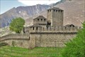 view gallery view gallerySW28.3 km | Montebello, Bellinzona, TI, Switzerland in Austrian and Swiss National Heritage Sites Montebello castle it's one of the three famous castles of the town of Bellinzona posted by: Torgut location: Ticino, Switzerland date approved: 07/27/2012 last visited: 08/02/2012 |
![Image for [CK] Castelli di Bellinzona (Switzerland)](https://img.geocaching.com/waymarking/small/4f21247a-287a-44a2-b657-4bc3c5d85c04.jpg) view gallery view gallerySW28.5 km |  [CK] Castelli di Bellinzona (Switzerland) [CK] Castelli di Bellinzona (Switzerland)
in World Heritage Sites "Three Castles, Defensive Wall and Ramparts of the Market-town of Bellinzona" (Switzerland).
Date of inscription: 2000 posted by:  kazuma kazuma location: Ticino, Switzerland date approved: 09/08/2005 last visited: 08/02/2012 |
 view gallery view gallery E29.3 km E29.3 km
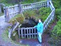
|  Maloja Gletschertöpfe, Graubünden, Schweiz Maloja Gletschertöpfe, Graubünden, Schweiz
in Places of Geologic Significance Maloja Gletschertöpfe, Graubünden, Schweiz posted by: luzzi-reloaded location: Graubünden, Switzerland date approved: 02/10/2012 last visited: 09/30/2013 |
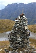 view gallery view galleryN29.5 km |  Cairn at Tomülpass - Safien, GR, Switzerland Cairn at Tomülpass - Safien, GR, Switzerland
in Cairns This summit cairn is located at the summit of Tomülpass. posted by: fi67 location: Graubünden, Switzerland date approved: 12/13/2014 last visited: never |
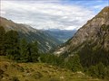 view gallery view galleryN29.5 km | Tomülpass - Safien, GR, Switzerland in Scenic Hikes The hiking trail over Tomülpass connects the valleys of Safien and Vals and takes about five to six hours. posted by: fi67 location: Graubünden, Switzerland date approved: 12/14/2014 last visited: never |
|