 view gallery view gallery NW11.9 km NW11.9 km
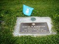
|   Marcus W. Robertson-Hood River, OR Marcus W. Robertson-Hood River, OR
in Medal Of Honor Resting Places Philippine Insurrection Medal of Honor Recipient for action near San Isidro, Philippine Islands on May 16, 1899. He is buried in Pine Grove Cemetery, Hood River, OR in Section 1, Lot 99. posted by:  Don.Morfe Don.Morfe location: Oregon date approved: 04/23/2018 last visited: 12/13/2021 |
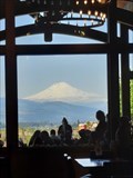 view gallery view galleryNW11.9 km |  Stave & Stone Winery - Hood River, OR Stave & Stone Winery - Hood River, OR
in Wineries They planted their first block of Pinot Noir in 2012. Broken Boulder Vineyard was named for the enormous basalt boulders that graced the fields, courtesy of Mt. Hood thousands of years ago. posted by:  RakeInTheCache RakeInTheCache location: Oregon date approved: 05/26/2023 last visited: never |
 view gallery view gallery N12.1 km N12.1 km
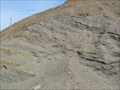
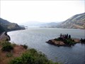
|  Mosier Eddy Bar, Mosier, Oregon Mosier Eddy Bar, Mosier, Oregon
in Glacial Lake Missoula Flood Features The Mosier Eddy Bar was created by the Missoula Ice Age Floods. posted by: Rose Red location: Oregon date approved: 04/08/2012 last visited: 11/27/2020 |
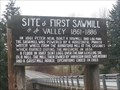 view gallery view galleryNW12.4 km |  Neal Creek Sawmill - Hood River, OR Neal Creek Sawmill - Hood River, OR
in First of its Kind This location on Neal Creek is the site of the first sawmill in the Hood River valley. posted by: dkestrel location: Oregon date approved: 10/03/2016 last visited: never |
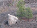 view gallery view galleryN12.4 km | Glacial Erratic, Mosier, Oregon in Glacial Lake Missoula Flood Features This glacial erratic is located in the midst of a rock quarry. It is quite large and probably weighs between 30 to 40 tons. posted by: Rose Red location: Oregon date approved: 11/07/2009 last visited: 12/26/2013 |
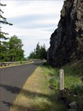
 view gallery view galleryN12.4 km |  Historic Columbia River Highway State Trail (Twin Tunnels Segment) Historic Columbia River Highway State Trail (Twin Tunnels Segment)
in Scenic Hikes A scenic hike along the historic scenic highway of the Columbia Gorge. This hike passes through two climate zones and the Mosier Twin Tunnels posted by: TheBeanTeam location: Oregon date approved: 08/21/2007 last visited: 12/26/2013 |
 view gallery view galleryN12.7 km |  Old Columbia River Scenic Highway Old Columbia River Scenic Highway
in Engineering Landmarks Stretching over 200 miles much of the original highway was destroyed in the 1950's. The coordinates lead you to an interpretive sign along the section of highway near Mosier Oregon that is now a bike and pedestrian trail. posted by: TheBeanTeam location: Oregon date approved: 08/17/2007 last visited: 11/27/2020 |
 view gallery view galleryN12.9 km |  Route 30 Electric Palm - Mosier, OR Route 30 Electric Palm - Mosier, OR
in Electric Palm Trees Route 30 Classics focuses on vintage Porsches and related gear but also shows off an electric palm in their display area. posted by: dkestrel location: Oregon date approved: 05/19/2016 last visited: 11/25/2022 |
 view gallery view galleryNW12.9 km |  The Ewe and I Farm - Hood River, OR The Ewe and I Farm - Hood River, OR
in Named Farms and Ranches A sheep farm in the beautiful Hood River Valley. posted by: dkestrel location: Oregon date approved: 12/15/2013 last visited: 12/16/2013 |
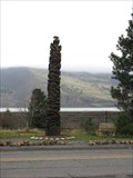 view gallery view galleryN12.9 km |  Mosier Oregon Totem Mosier Oregon Totem
in Outside Wooden Display Carvings A very well made totem in Mosier, Oregon. posted by: Queens Blessing location: Oregon date approved: 12/08/2008 last visited: 11/25/2022 |
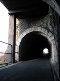 view gallery view galleryN13 km |  Mosier Tunnels, Oregon Mosier Tunnels, Oregon
in American Guide Series The Mosier Tunnels earned a reference in the 1940's American Guide Series book entitled "Oregon: End of the Trail". Coordinates are for the east portal of the former scenic highway turned hiking trail. posted by: TheBeanTeam location: Oregon date approved: 01/18/2008 last visited: 12/26/2013 |
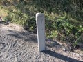
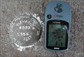 view gallery view galleryN13 km |  W533 State Highway Marker W533 State Highway Marker
in U.S. Benchmarks I84 Mosier off ramp bridge over the railroad. posted by: wiltonh location: Oregon date approved: 09/22/2007 last visited: 11/20/2022 |
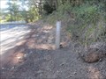
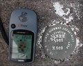 view gallery view galleryN13 km | X569 on I84 Overpass at Moiser Oregon in U.S. Benchmarks X569 is on the Southeast corner of the I84 off ramp bridge. posted by: wiltonh location: Oregon date approved: 09/22/2007 last visited: never |
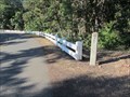
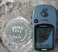 view gallery view galleryN13.2 km | W569 Oregon State Highway Department in U.S. Benchmarks This is on the South West corner of the I-84 bridge over Rock Creek near Mosier Oregon. There is a white line on the South side of the concrete guard rail that points to the marker. The white line can be seen in the wide angle shot. posted by: wiltonh location: Oregon date approved: 09/15/2007 last visited: never |
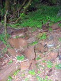 view gallery view galleryN13.4 km |  Car - Mosier, Oregon Car - Mosier, Oregon
in Abandoned Dead Vehicles Very little is left of this abandoned vehicle on the Old Columbia Highway. This section of the highway has been turned into a hiking and biking trail. posted by: TheBeanTeam location: Oregon date approved: 07/18/2007 last visited: 07/18/2007 |
 view gallery view gallery NE14.3 km NE14.3 km
|  Mile Marker 79, Historic Hwy 30, Oregon Mile Marker 79, Historic Hwy 30, Oregon
in Milestones This is mile marker #79, on Historic Hwy 30, which was built between 1913 and 1922. posted by: Queens Blessing location: Oregon date approved: 09/01/2013 last visited: 09/02/2013 |
 view gallery view galleryNE14.8 km | Mile Marker 81, Historic Hwy 30, Oregon in Milestones This is mile marker #81, on Historic Hwy 30, which was built between 1913 and 1922. posted by: Queens Blessing location: Oregon date approved: 08/17/2013 last visited: 09/02/2013 |
 view gallery view galleryNW14.8 km |  Highline Rd Wagon Wheels - Hood River, Oregon Highline Rd Wagon Wheels - Hood River, Oregon
in Wagon Wheels A driveway on the hill overlooking Hood River is lined with old wagon wheels. posted by: dkestrel location: Oregon date approved: 02/01/2016 last visited: 11/27/2020 |
 view gallery view galleryNE15 km | Mile Marker 78, Historic Hwy 30 - Mosier, Oregon in Milestones This is mile marker #78, on Historic Hwy 30, which was built between 1913 and 1922. posted by: Queens Blessing location: Oregon date approved: 08/10/2013 last visited: 09/02/2013 |
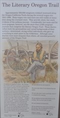 view gallery view galleryN15 km |  The Literary Oregon Trail The Literary Oregon Trail
in Oregon Historical Markers This is one of 13 historical markers in a special kiosk, devoted to the history of the Oregon Trail, and located at the Memaloose Park Rest Area on the south side of Interstate Highway 84 about 3.1 miles east of Mosier, Oregon. posted by: brwhiz location: Oregon date approved: 02/05/2013 last visited: 06/25/2014 |
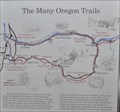 view gallery view galleryN15 km | The Many Oregon Trails in Oregon Historical Markers This is one of 13 historical markers in a special kiosk, devoted to the history of the Oregon Trail, and located at the Memaloose Park Rest Area on the south side of Interstate Highway 84 about 3.1 miles east of Mosier, Oregon. posted by: brwhiz location: Oregon date approved: 02/05/2013 last visited: 06/25/2014 |
 view gallery view galleryN15 km | Diseases Devastate Tribes in Oregon Historical Markers This is one of 13 historical markers in a special kiosk, devoted to the history of the Oregon Trail, and located at the Memaloose Park Rest Area on the south side of Interstate Highway 84 about 3.1 miles east of Mosier, Oregon. posted by: brwhiz location: Oregon date approved: 02/05/2013 last visited: 06/25/2014 |
 view gallery view galleryN15 km | Indians and Emigrants in Oregon Historical Markers This is one of 13 historical markers in a special kiosk, devoted to the history of the Oregon Trail, and located at the Memaloose Park Rest Area on the south side of Interstate Highway 84 about 3.1 miles east of Mosier, Oregon. posted by: brwhiz location: Oregon date approved: 02/05/2013 last visited: 06/25/2014 |
 view gallery view galleryN15 km | Land Not for Sale in Oregon Historical Markers This is one of 13 historical markers in a special kiosk, devoted to the history of the Oregon Trail, and located at the Memaloose Park Rest Area on the south side of Interstate Highway 84 about 3.1 miles east of Mosier, Oregon. posted by: brwhiz location: Oregon date approved: 02/05/2013 last visited: 06/25/2014 |
 view gallery view galleryN15 km | Pathway to the "Garden of the World" in Oregon Historical Markers This is one of 13 historical markers in a special kiosk, devoted to the history of the Oregon Trail, and located at the Memaloose Park Rest Area on the south side of Interstate Highway 84 about 3.1 miles east of Mosier, Oregon. posted by: brwhiz location: Oregon date approved: 02/03/2013 last visited: 06/25/2014 |
|