 view gallery view gallery S9.2 km S9.2 km
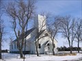
|   Bergen Lutheran Church - SD Bergen Lutheran Church - SD
in Country Churches In Brown County near Bristol SD. posted by:  MNSearchers MNSearchers location: South Dakota date approved: 03/19/2007 last visited: 03/20/2007 |
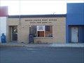
 view gallery view gallery W10.5 km W10.5 km
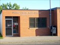
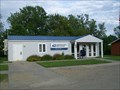
|  Pierpont, South Dakota 57486 Pierpont, South Dakota 57486
in U.S. Post Offices Small town post office. posted by: NGComets location: South Dakota date approved: 06/07/2010 last visited: never |
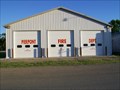 view gallery view galleryW10.5 km |  Pierpont Fire Dept. Pierpont Fire Dept.
in Firehouses Small town fire department. posted by: NGComets location: South Dakota date approved: 06/08/2010 last visited: never |
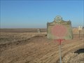
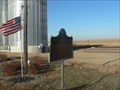
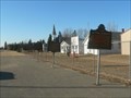
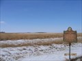 view gallery view galleryW10.8 km |  Charles H. Sheldon (1893 – 1897) 2nd Governor of SD Charles H. Sheldon (1893 – 1897) 2nd Governor of SD
in South Dakota Historical Markers Charles H. Sheldon was born in Lamoille County, Vermont, the third of four children of Gresham and Mary (Brown) Sheldon. posted by: MNSearchers location: South Dakota date approved: 02/20/2007 last visited: 06/03/2010 |
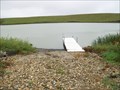
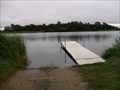 view gallery view gallery SW12.2 km SW12.2 km
|  Pierpont Lake Boat Ramp, Pierpont, South Dakota Pierpont Lake Boat Ramp, Pierpont, South Dakota
in Boat Ramps This boat ramp is located about two miles south of Pierpont, SD, on SD Highway 27.
Elevation 1528 posted by: NGComets location: South Dakota date approved: 11/07/2017 last visited: never |
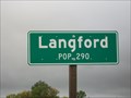 view gallery view gallery NW12.9 km NW12.9 km
|  Langford, South Dakota - Population 290 Langford, South Dakota - Population 290
in Population Signs A small town in Marshall County, SD, along SD Hwy 17.
Elevation 1372 posted by: NGComets location: South Dakota date approved: 12/17/2017 last visited: never |
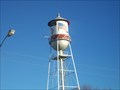
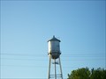 view gallery view galleryNW13.2 km |  Watertower, Langford, South Dakota Watertower, Langford, South Dakota
in Water Towers Small town watertower. posted by: NGComets location: South Dakota date approved: 06/09/2010 last visited: never |
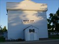 view gallery view galleryNW13.4 km |  "American Legion Post 141" Langford, South Dakota "American Legion Post 141" Langford, South Dakota
in Legion Posts and Branches Post named for Henry Osness, the son of Mr. and Mrs. John Osness, living at Langford and was killed in action in France during WW1. posted by: NGComets location: South Dakota date approved: 06/09/2010 last visited: never |
 view gallery view gallery N15.6 km N15.6 km
| Hickman Lake Boat Ramp, Langford, South Dakota in Boat Ramps Located about 6 miles northeast of Langford, South Dakota.
Elevation 1440 posted by: NGComets location: South Dakota date approved: 11/03/2017 last visited: never |
 view gallery view gallery E16.7 km E16.7 km
| Roslyn, South Dakota 57261 in U.S. Post Offices Small town post office. posted by: NGComets location: South Dakota date approved: 11/15/2010 last visited: 03/17/2011 |
 view gallery view gallery SE16.7 km SE16.7 km
| Pioneering in Dakota - Prairie Fires in South Dakota Historical Markers Site of first recorded death by prairie fire in the Dakotas. posted by: plainsdrifter358 location: South Dakota date approved: 12/21/2006 last visited: 11/05/2011 |
 view gallery view galleryE16.7 km | Water Tower, Roslyn, South Dakota in Water Towers Small town watertower. posted by: NGComets location: South Dakota date approved: 11/15/2010 last visited: 03/17/2011 |
 view gallery view galleryS19.8 km |  Bristol, SD Bristol, SD
in Small Town, Big Name Bristol, SD is named after the college town in England. posted by: plainsdrifter358 location: South Dakota date approved: 12/22/2006 last visited: 10/10/2009 |
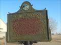
 view gallery view galleryS19.8 km | Bristol -1881- in South Dakota Historical Markers Bristol, SD in Day County was established in 1881. posted by: plainsdrifter358 location: South Dakota date approved: 12/20/2006 last visited: 02/19/2007 |
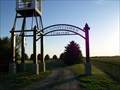
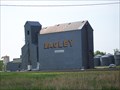 view gallery view gallerySW19.8 km |  Bagley Elevator, Andover, South Dakota Bagley Elevator, Andover, South Dakota
in Grain Elevators A small town grain elevator in Andover, SD, started by George C. Bagley. posted by: NGComets location: South Dakota date approved: 06/06/2011 last visited: never |
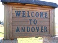 view gallery view gallerySW20 km | Andover, South Dakota in Small Town, Big Name Andover, South Dakota - Population 99
Andover, Massachusetts - Population 31,247
Andover, England - Population 112,000 posted by: NGComets location: South Dakota date approved: 11/06/2009 last visited: never |
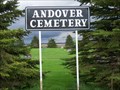 view gallery view gallerySW20.6 km |  Andover Cemetery, Andover, South Dakota Andover Cemetery, Andover, South Dakota
in Worldwide Cemeteries Small cemetery just north of town. Elevation 1488. posted by: NGComets location: South Dakota date approved: 06/18/2013 last visited: never |
 view gallery view gallerySW20.6 km | All Saints Catholic Cemetery, Andover, South Dakota in Worldwide Cemeteries Catholic cemetery just west of town. Elevation 1465 posted by: NGComets location: South Dakota date approved: 06/13/2017 last visited: never |
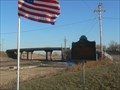
 view gallery view gallerySE24 km | The Fight At Webster in South Dakota Historical Markers Rebel band of Indians guilty of murder in the aftermath of the Minnesota Massacre of 1862 are killed in a gun fight near Webster, SD. posted by: plainsdrifter358 location: South Dakota date approved: 12/20/2006 last visited: 11/05/2011 |
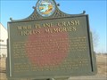 view gallery view gallerySE24 km | WWII Plane Crash Holds Memories in South Dakota Historical Markers One 25 October 1944 a A26-B two engine medium bomber from Watertown Army airbase crashed 2mi S and 1mi E of this site. posted by: plainsdrifter358 location: South Dakota date approved: 12/20/2006 last visited: 11/05/2011 |
 view gallery view gallerySE24 km | Sigurd Andersen in South Dakota Historical Markers Sigurd Andersen, 19th Governor of SD 1951-1955 posted by: plainsdrifter358 location: South Dakota date approved: 12/20/2006 last visited: 11/05/2011 |
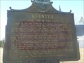 view gallery view gallerySE24 km | Webster - County Seat of Day County in South Dakota Historical Markers Webster, founded in 1881, is County Seat of Day County. posted by: plainsdrifter358 location: South Dakota date approved: 12/20/2006 last visited: 11/05/2011 |
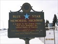 view gallery view gallerySE24 km |  U.S. Highway 12, Webster, SD U.S. Highway 12, Webster, SD
in Blue Star Memorial Highway Markers Located along Highway 12 in Webster SD. Day County. posted by: MNSearchers location: South Dakota date approved: 02/20/2007 last visited: 11/05/2011 |
 view gallery view gallery NE24.3 km NE24.3 km
| Eden, South Dakota 57232 in U.S. Post Offices Small town post office. posted by: NGComets location: South Dakota date approved: 07/19/2015 last visited: never |
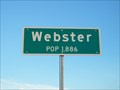 view gallery view gallerySE24.3 km | Webster Population in Population Signs Small community located in Day County at the junction of US Highway 12 and SD Highway 25. posted by: NGComets location: South Dakota date approved: 08/13/2015 last visited: never |
|