 view gallery view gallery W0 km W0 km
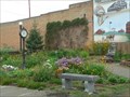
|   Town Clock in Webster, SD Town Clock in Webster, SD
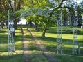
in Town Clocks Town Clock, mural and mini-park on Main Street in Webster, SD posted by:  plainsdrifter358 plainsdrifter358 location: South Dakota date approved: 08/10/2007 last visited: 11/05/2011 |
 view gallery view gallery S0.2 km S0.2 km
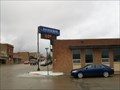
|  Dakotah Bank, Webster, South Dakota Dakotah Bank, Webster, South Dakota
in Time and Temperature Signs On the corner of 6th and Main. Elevation 1897 posted by: NGComets location: South Dakota date approved: 06/18/2013 last visited: never |
 view gallery view gallery N1 km N1 km
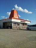
|  A&W - Webster, South Dakota A&W - Webster, South Dakota
in A + W Restaurants This A&W has a dirt/gravel lot. posted by: SageInThyme82 location: South Dakota date approved: 08/14/2015 last visited: 06/09/2007 |
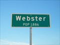 view gallery view galleryN1.4 km |  Webster Population Webster Population
in Population Signs Small community located in Day County at the junction of US Highway 12 and SD Highway 25. posted by: NGComets location: South Dakota date approved: 08/13/2015 last visited: never |
 view gallery view gallery NW1.6 km NW1.6 km
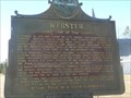
|  Sigurd Andersen Sigurd Andersen
in South Dakota Historical Markers Sigurd Andersen, 19th Governor of SD 1951-1955 posted by: plainsdrifter358 location: South Dakota date approved: 12/20/2006 last visited: 11/05/2011 |
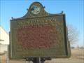
 view gallery view galleryNW1.6 km | Webster - County Seat of Day County in South Dakota Historical Markers Webster, founded in 1881, is County Seat of Day County. posted by: plainsdrifter358 location: South Dakota date approved: 12/20/2006 last visited: 11/05/2011 |
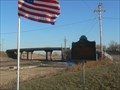
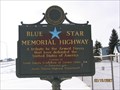 view gallery view galleryNW1.6 km |  U.S. Highway 12, Webster, SD U.S. Highway 12, Webster, SD
in Blue Star Memorial Highway Markers Located along Highway 12 in Webster SD. Day County. posted by: MNSearchers location: South Dakota date approved: 02/20/2007 last visited: 11/05/2011 |
 view gallery view galleryNW1.6 km | The Fight At Webster in South Dakota Historical Markers Rebel band of Indians guilty of murder in the aftermath of the Minnesota Massacre of 1862 are killed in a gun fight near Webster, SD. posted by: plainsdrifter358 location: South Dakota date approved: 12/20/2006 last visited: 11/05/2011 |
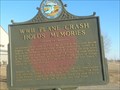 view gallery view galleryNW1.6 km | WWII Plane Crash Holds Memories in South Dakota Historical Markers One 25 October 1944 a A26-B two engine medium bomber from Watertown Army airbase crashed 2mi S and 1mi E of this site. posted by: plainsdrifter358 location: South Dakota date approved: 12/20/2006 last visited: 11/05/2011 |
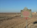 view gallery view galleryN13.8 km | Pioneering in Dakota - Prairie Fires in South Dakota Historical Markers Site of first recorded death by prairie fire in the Dakotas. posted by: plainsdrifter358 location: South Dakota date approved: 12/21/2006 last visited: 11/05/2011 |
 view gallery view gallery E16.3 km E16.3 km
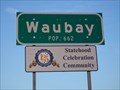
| Waubay Population in Population Signs A small city in Day County, South Dakota. posted by: NGComets location: South Dakota date approved: 08/13/2015 last visited: never |
 view gallery view gallery SW16.6 km SW16.6 km
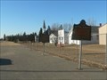
|  Prairie Mound Cemetery, Butler, South Dakota Prairie Mound Cemetery, Butler, South Dakota
in Worldwide Cemeteries Small community cemetery just north of town.
Elevation 1819 posted by: NGComets location: South Dakota date approved: 06/20/2017 last visited: never |
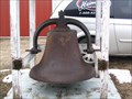 view gallery view galleryE16.7 km |  Bell, Fire Department, Waubay, South Dakota Bell, Fire Department, Waubay, South Dakota
in Bells Retired fire department bell. posted by: NGComets location: South Dakota date approved: 03/16/2010 last visited: never |
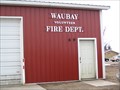 view gallery view galleryE16.7 km |  Waubay Volunteer Fire Dept. Waubay Volunteer Fire Dept.
in Firehouses Small town fire department in Waubay, South Dakota. posted by: NGComets location: South Dakota date approved: 03/16/2010 last visited: never |
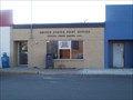
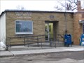 view gallery view galleryE16.9 km |  Waubay, South Dakota 57273 Waubay, South Dakota 57273
in U.S. Post Offices Small town post office. posted by: NGComets location: South Dakota date approved: 03/16/2010 last visited: never |
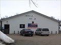 view gallery view galleryE16.9 km |  "American Legion Post 129" Waubay, South Dakota "American Legion Post 129" Waubay, South Dakota
in Legion Posts and Branches Active post in a small town named for Brady and Monson. posted by: NGComets location: South Dakota date approved: 03/16/2010 last visited: never |
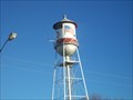
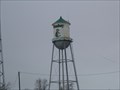 view gallery view galleryE16.9 km |  Watertower, Waubay, South Dakota Watertower, Waubay, South Dakota
in Water Towers Small town watertower. posted by: NGComets location: South Dakota date approved: 03/16/2010 last visited: never |
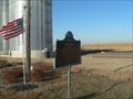
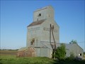 view gallery view gallerySW17.1 km |  Bagley Elevator, Butler, South Dakota Bagley Elevator, Butler, South Dakota
in Ghost Signs An abandoned grain elevator. Elevation 1832 posted by: NGComets location: South Dakota date approved: 06/14/2017 last visited: never |
 view gallery view galleryS17.4 km | Hosanger Cemetery, Lily, South Dakota in Worldwide Cemeteries A small cemetery on SD Highway 25. posted by: NGComets location: South Dakota date approved: 06/17/2012 last visited: never |
 view gallery view galleryW18 km | Bristol -1881- in South Dakota Historical Markers Bristol, SD in Day County was established in 1881. posted by: plainsdrifter358 location: South Dakota date approved: 12/20/2006 last visited: 02/19/2007 |
 view gallery view galleryW18 km |  Bristol, SD Bristol, SD
in Small Town, Big Name Bristol, SD is named after the college town in England. posted by: plainsdrifter358 location: South Dakota date approved: 12/22/2006 last visited: 10/10/2009 |
 view gallery view galleryN18.3 km | Water Tower, Roslyn, South Dakota in Water Towers Small town watertower. posted by: NGComets location: South Dakota date approved: 11/15/2010 last visited: 03/17/2011 |
 view gallery view galleryN18.3 km | Roslyn, South Dakota 57261 in U.S. Post Offices Small town post office. posted by: NGComets location: South Dakota date approved: 11/15/2010 last visited: 03/17/2011 |
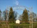
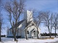 view gallery view galleryNW19.3 km |  Bergen Lutheran Church - SD Bergen Lutheran Church - SD
in Country Churches In Brown County near Bristol SD. posted by: MNSearchers location: South Dakota date approved: 03/19/2007 last visited: 03/20/2007 |
 view gallery view gallerySW20.4 km | Hillside Cemetery, Lily, South Dakota in Worldwide Cemeteries A small cemetery east of town. Elevation 1857 posted by: NGComets location: South Dakota date approved: 06/13/2017 last visited: never |
|