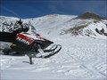
 view gallery view gallery NE4.2 km NE4.2 km
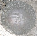
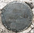
|   PY1097 - 1964 USGS 10EAM - Montana PY1097 - 1964 USGS 10EAM - Montana
in U.S. Benchmarks U.S. Geological Survey benchmark 10EAM. posted by:  Volcanoguy Volcanoguy location: Montana date approved: 10/07/2011 last visited: 09/27/2010 |
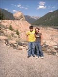
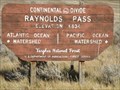
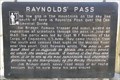 view gallery view galleryNE5.3 km |  Raynolds’ Pass Raynolds’ Pass
in Montana Historical Markers History sign about the history of Raynolds’ Pass. posted by: Volcanoguy location: Montana date approved: 10/07/2011 last visited: 09/27/2010 |
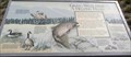
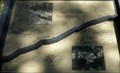
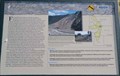 view gallery view galleryNE5.3 km | Earthquakes! in Montana Historical Markers Montana Department of Transportation history/geology sign about earthquakes and the Hebgen Lake Earthquake. posted by: Volcanoguy location: Montana date approved: 10/07/2011 last visited: 08/03/2020 |
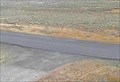
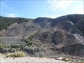 view gallery view gallery E8 km E8 km
|  Madison Slide Overlook - Montana Madison Slide Overlook - Montana
in Scenic Roadside Look-Outs The Madison Slide overlook along U.S. Hwy. 287 above the Earthquake Lake Visitor Center. posted by: Volcanoguy location: Montana date approved: 10/07/2011 last visited: 05/29/2021 |
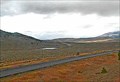
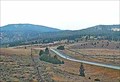
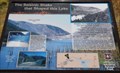
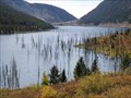
 view gallery view galleryE8.2 km |  Earthquake Lake Earthquake Lake
in Places of Geologic Significance Quake Lake (also known as Earthquake Lake) was created after a massive earthquake struck southwestern Montana, United States on August 17, 1959. posted by: newlifelawn location: Montana date approved: 02/27/2007 last visited: 08/27/2019 |
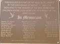 view gallery view galleryE8.2 km |  Hebgen Lake Earthquake Hebgen Lake Earthquake
in Disaster Memorials Memorial to the victims of the Hebgen Lake Earthquake on August 17, 1959. posted by: Volcanoguy location: Montana date approved: 10/06/2011 last visited: 05/29/2021 |
 view gallery view gallery SE9.3 km SE9.3 km
|  Raynolds Pass North Web Camera - Henry's Lake, MT Raynolds Pass North Web Camera - Henry's Lake, MT
in Web Cameras This is one of 73 (as of January 2017) Road Weather Information System camera sites operated by the Montana Department of Transportation to aid motorists as they make their way across BIG SKY Country. posted by: T0SHEA location: Montana date approved: 02/06/2017 last visited: never |
 view gallery view gallerySE9.3 km | Raynolds Pass Northwest Web Camera - Henry's Lake, MT in Web Cameras This is one of 73 (as of January 2017) Road Weather Information System camera sites operated by the Montana Department of Transportation to aid motorists as they make their way across BIG SKY Country. posted by: T0SHEA location: Montana date approved: 02/06/2017 last visited: never |
 view gallery view gallerySE9.3 km | Raynolds Pass Roadway Web Camera - Henry's Lake, MT in Web Cameras This is one of 73 (as of January 2017) Road Weather Information System camera sites operated by the Montana Department of Transportation to aid motorists as they make their way across BIG SKY Country. posted by: T0SHEA location: Montana date approved: 02/06/2017 last visited: never |
 view gallery view gallerySE9.3 km | Raynolds Pass South Web Camera - Henry's Lake, MT in Web Cameras This is one of 73 (as of January 2017) Road Weather Information System camera sites operated by the Montana Department of Transportation to aid motorists as they make their way across BIG SKY Country. posted by: T0SHEA location: Montana date approved: 02/06/2017 last visited: never |
 view gallery view galleryNE10.9 km | The Seismic Shake that Shaped this Lake in Montana Historical Markers On the night of August 17, 1959, a 7.3 magnitude earthquake in Madison River Canyon caused a massive landslide. The landslide created a dam that sealed the west end of the canyon, blocking the flow of the river and creating a new lake overnight. posted by:  Cosmos Mariner Cosmos Mariner location: Montana date approved: 09/09/2012 last visited: 08/27/2019 |
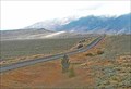
 view gallery view gallerySE11.1 km | 1948 USGS JRH19 - Montana/Idaho in U.S. Benchmarks U.S. Geological Survey benchmark JRH19. posted by: Volcanoguy location: Montana date approved: 10/07/2011 last visited: 07/15/2004 |
 view gallery view gallerySE11.1 km |  Idaho/Montana on Hwy 87 at Raynolds Pass Idaho/Montana on Hwy 87 at Raynolds Pass
in Border Crossings Summit sign on Hwy. 87 at Idaho/Montana border. posted by: Volcanoguy location: Montana date approved: 11/22/2010 last visited: 07/10/2008 |
 view gallery view gallerySE11.1 km |  Continental Divide at Raynolds Pass - Idaho/Montana Continental Divide at Raynolds Pass - Idaho/Montana
in Elevation Signs Elevation sign on Hwy. 87 at Idaho/Montana border. posted by: Volcanoguy location: Montana date approved: 11/22/2010 last visited: 08/18/2010 |
 view gallery view galleryNE11.9 km | The Seismic Shake that Shaped this Lake in Montana Historical Markers Gallatin National Forest sign about the August 17, 1959 earthquake and the resulting changes to the area. posted by: Volcanoguy location: Montana date approved: 10/06/2011 last visited: 01/04/2016 |
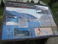
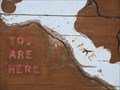
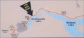 view gallery view galleryNE11.9 km |  Earthquake Lake Earthquake Lake
in 'You Are Here' Maps You Are Here marker along U.S. Hwy. 287 at Earthquake Lake viewpoint. posted by: Volcanoguy location: Montana date approved: 10/09/2011 last visited: 05/29/2021 |
 view gallery view galleryNE11.9 km | Earthquake Lake Overlook - Montana in Scenic Roadside Look-Outs The Earthquake Lake overlook along U.S. Hwy. 287 at Earthquake Lake. posted by: Volcanoguy location: Montana date approved: 10/06/2011 last visited: 01/04/2016 |
 view gallery view gallerySE11.9 km | North of Targhee Peak in U.S. Benchmarks Top of mountain saddle. Metal Pipe with marker approximately 12" above ground level. On or very near MT/ID boarder posted by: gkart65 location: Montana date approved: 05/31/2009 last visited: never |
 view gallery view galleryNE14 km |  Giving Wetlands a Helping Hand - Montana Giving Wetlands a Helping Hand - Montana
in Flora and Fauna Information Signs This information sign is located along U.S. Hwy. 287 at about mile point 7.0. posted by: Volcanoguy location: Montana date approved: 10/06/2011 last visited: 09/27/2010 |
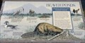 view gallery view galleryNE14 km | Beaver Ponds - Montana in Flora and Fauna Information Signs This information sign is located along U.S. Hwy. 287 at about mile point 7.0. posted by: Volcanoguy location: Montana date approved: 10/06/2011 last visited: 09/27/2010 |
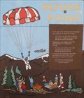 view gallery view galleryNE15.1 km | Refuge Point in Montana Historical Markers Gallatin National Forest sign about the August 17, 1959 earthquake and the survivors at Refuge Point. posted by: Volcanoguy location: Montana date approved: 10/06/2011 last visited: 06/29/2011 |
 view gallery view galleryNE16.4 km | An Earthquake . . . Split This Camp in Montana Historical Markers Gallatin National Forest sign about the effects of the August 17, 1959 earthquake at the Cabin Creek Campground. posted by: Volcanoguy location: Montana date approved: 10/05/2011 last visited: 09/27/2010 |
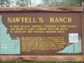 view gallery view gallerySE17.1 km |  Sawtell's Ranch Sawtell's Ranch
in Idaho Historical Markers Roadside marker in Idaho. posted by: Biker Ozzy location: Idaho date approved: 02/27/2011 last visited: 08/03/2020 |
 view gallery view gallerySE20.4 km | Building Destruction in Montana Historical Markers Gallatin National Forest sign about the effects of the August 17, 1959 earthquake near this location. posted by: Volcanoguy location: Montana date approved: 10/05/2011 last visited: 09/27/2010 |
 view gallery view galleryE21.7 km | Hebgen Lake - Montana in 'You Are Here' Maps You Are Here marker along U.S. Hwy. 287 at Hebgen Lake viewpoint. posted by: Volcanoguy location: Montana date approved: 10/05/2011 last visited: 09/27/2010 |
|