 view gallery view gallery W22.7 km W22.7 km
|   QD1270 - USCGS Y111, OR QD1270 - USCGS Y111, OR
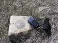
in U.S. Benchmarks USCGS benchmark Y111 along Ore. Hwy. 27. posted by:  Volcanoguy Volcanoguy location: Oregon date approved: 04/14/2008 last visited: 04/22/2011 |
 view gallery view galleryW24.1 km | QD1262 - USCGS W111, OR in U.S. Benchmarks USCGS benchmark W111 along Ore. Hwy. 27. posted by: Volcanoguy location: Oregon date approved: 04/14/2008 last visited: 04/22/2011 |
 view gallery view gallery S24.3 km S24.3 km
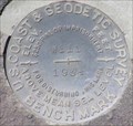
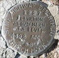
| PB0106 - USCGS B284, Oregon in U.S. Benchmarks U.S. Coast & Geodetic Survey benchmark B284. posted by: Volcanoguy location: Oregon date approved: 05/25/2009 last visited: 04/07/2009 |
 view gallery view gallery SW24.3 km SW24.3 km
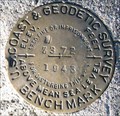
| PB0104 - USCGS B373, Oregon in U.S. Benchmarks U.S. Coast & Geodetic Survey benchmark B373. posted by: Volcanoguy location: Oregon date approved: 05/25/2009 last visited: 04/07/2009 |
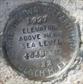
 view gallery view galleryS24.5 km | PB0107 - OSHD 38, Oregon in U.S. Benchmarks Oregon State Highway Department benchmark 38. posted by: Volcanoguy location: Oregon date approved: 05/25/2009 last visited: 04/07/2009 |
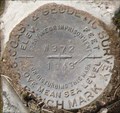
 view gallery view gallerySW24.6 km | PB0102 - USCGS Z372, Oregon in U.S. Benchmarks U.S. Coast & Geodetic Survey benchmark Z372. posted by: Volcanoguy location: Oregon date approved: 05/25/2009 last visited: 04/07/2009 |
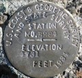
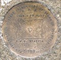 view gallery view gallerySW24.8 km | PB0791 - ODOT BROTHERS, Oregon in U.S. Benchmarks Oregon Department of Transportation G.P.S. Station BROTHERS. posted by: Volcanoguy location: Oregon date approved: 02/26/2009 last visited: 02/28/2009 |
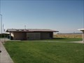 view gallery view gallerySW24.8 km |  U.S. Route 20 - Brothers, OR U.S. Route 20 - Brothers, OR
in Highway Rest Areas Brothers, Oregon, is not much more than a rest stop itself, but is a welcome site on the long trek across the central Oregon high desert. The only highway rest area I've seen with a horse exercise area! Great info plaques here,too. See photo gallery posted by:  silverquill silverquill location: Oregon date approved: 12/20/2007 last visited: 02/19/2009 |
 view gallery view gallerySW24.8 km |  Observations from Homestead Era Observations from Homestead Era
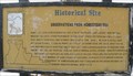
in Oregon Historical Markers Sign about homesteading on the High Desert of central Oregon.
posted by: Volcanoguy location: Oregon date approved: 02/25/2009 last visited: 02/25/2009 |
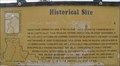 view gallery view gallerySW24.8 km | History of Brothers, Hampton and Millican Valley in Oregon Historical Markers Sign about history of the High Desert of central Oregon. posted by: Volcanoguy location: Oregon date approved: 02/25/2009 last visited: 02/25/2009 |
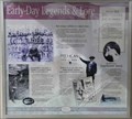 view gallery view gallerySW24.8 km | Early-Day Legends & Lore in Oregon Historical Markers Sign about Legends and Lore of the High Desert of central Oregon. posted by: Volcanoguy location: Oregon date approved: 02/25/2009 last visited: 02/25/2009 |
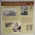 view gallery view gallerySW24.8 km | Trails and Tribulations - History of the Brothers Area in Oregon Historical Markers Sign about historic trails. posted by: Volcanoguy location: Oregon date approved: 02/25/2009 last visited: 02/25/2009 |
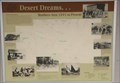 view gallery view gallerySW24.8 km | Desert Dreams . . . Brothers Area 1845 to Present in Oregon Historical Markers Sign about cultural history of the Brothers Area. posted by: Volcanoguy location: Oregon date approved: 02/25/2009 last visited: 02/25/2009 |
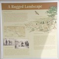 view gallery view gallerySW24.8 km | A Rugged Landscape in Oregon Historical Markers Sign about geology of the Brothers Area. posted by: Volcanoguy location: Oregon date approved: 02/25/2009 last visited: 02/25/2009 |
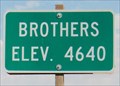 view gallery view gallerySW24.9 km |  Brothers Elev 4,640 feet - Brothers, OR Brothers Elev 4,640 feet - Brothers, OR
in Elevation Signs This elevation sign is in the small wayside town of Brothers, Oregon, on Route 20 in Oregon's high desert country. posted by: silverquill location: Oregon date approved: 10/31/2007 last visited: 04/06/2009 |
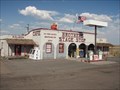
 view gallery view gallerySW24.9 km |  Brothers Stage Stop Cafe - Brothers, Oregon Brothers Stage Stop Cafe - Brothers, Oregon
in Independent Diners This probably was a stage stop in the early days, and is still about the only thing in the town of brothers - cafe, store, and post office. The proverbial wide spot in the road while traveling Route 20 across Oregons central high desert country. posted by: silverquill location: Oregon date approved: 11/04/2007 last visited: 02/19/2009 |
 view gallery view gallerySW24.9 km |  Brothers, OR 97712 Brothers, OR 97712
in U.S. Post Offices A "stage stop" post office in the remote roadside town of Brothers, Oregon, in the high desert country, along Route 20. posted by: silverquill location: Oregon date approved: 10/31/2007 last visited: 02/19/2009 |
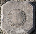
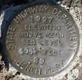 view gallery view galleryS25.1 km | PB0015 - OSHD 39, Oregon in U.S. Benchmarks Oregon State Highway Department benchmark 39. posted by: Volcanoguy location: Oregon date approved: 05/25/2009 last visited: 04/07/2009 |
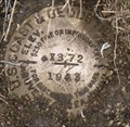
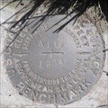
 view gallery view gallerySW25.3 km | PB0100 - USCGS Y372, Oregon in U.S. Benchmarks U.S. Coast & Geodetic Survey benchmark Y372. posted by: Volcanoguy location: Oregon date approved: 02/26/2009 last visited: 02/28/2009 |
 view gallery view gallerySW25.3 km | PB0139 - OSHD 33, Oregon in U.S. Benchmarks Oregon State Hwy. Dept. benchmark 33. posted by: Volcanoguy location: Oregon date approved: 04/30/2009 last visited: 04/03/2009 |
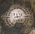
 view gallery view gallerySW25.7 km | PB0099 - USCGS X372, Oregon in U.S. Benchmarks U.S. Coast & Geodetic Survey benchmark X372. posted by: Volcanoguy location: Oregon date approved: 02/24/2009 last visited: 02/24/2009 |
 view gallery view gallerySW25.7 km | PB0138 - USCGS G373, Oregon in U.S. Benchmarks Former U.S. Coast & Geodetic Survey benchmark G373. posted by: Volcanoguy location: Oregon date approved: 02/28/2009 last visited: 02/28/2009 |
 view gallery view gallerySW26.4 km | PB0098 - USCGS W372, Oregon in U.S. Benchmarks U.S. Coast & Geodetic Survey benchmark W372. posted by: Volcanoguy location: Oregon date approved: 02/24/2009 last visited: 02/24/2009 |
 view gallery view galleryW26.4 km | PB0158 - USCGS A112, OR in U.S. Benchmarks USCGS benchmark A112 along Ore. Hwy. 27.
posted by: Volcanoguy location: Oregon date approved: 04/14/2008 last visited: 04/22/2011 |
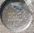 view gallery view galleryS26.4 km | PB0017 - OHD 40, Oregon in U.S. Benchmarks Oregon Highway Department benchmark 40 posted by: Volcanoguy location: Oregon date approved: 03/05/2011 last visited: 10/02/2009 |
|