 view gallery view gallery SW22.4 km SW22.4 km
|   Ernest Hemingway - Ketchum, ID Ernest Hemingway - Ketchum, ID
in Grave of a Famous Person Grave of journalist, Pulitzer Prize-winning author and Nobel laureate in literature, Ernest Hemingway. posted by:  hykesj hykesj location: Idaho date approved: 03/04/2023 last visited: never |
 view gallery view gallery NW26.1 km NW26.1 km
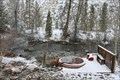
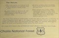
|  Bowery Hot Springs Bowery Hot Springs
in Hot Springs Bowery Hot Springs is just beyond the Bowery Guard Station along the East Fork of the Salmon River. posted by: chuktA location: Idaho date approved: 10/04/2011 last visited: 03/05/2011 |
 view gallery view gallery NE38.8 km NE38.8 km
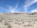
|  Leatherman Peak View - Idaho Leatherman Peak View - Idaho
in Scenic Roadside Look-Outs View point and sign for Leatherman Peak. posted by: Volcanoguy location: Idaho date approved: 07/26/2011 last visited: 09/24/2010 |
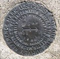
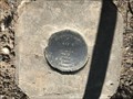
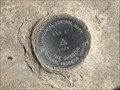
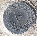 view gallery view galleryNE39.4 km |  PZ0772 - USCGS SAW, Idaho PZ0772 - USCGS SAW, Idaho
in U.S. Benchmarks U.S. Coast & Geodetic Survey triangulation station SAW. posted by: Volcanoguy location: Idaho date approved: 07/26/2011 last visited: 09/24/2010 |
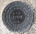 view gallery view galleryNE39.4 km | PZ0772 - USCGS SAW NO 1, Idaho in U.S. Benchmarks U.S. Coast & Geodetic Survey reference mark SAW NO 1. posted by: Volcanoguy location: Idaho date approved: 07/27/2011 last visited: 09/24/2010 |
 view gallery view galleryNE39.4 km | PZ0772 - USCGS SAW NO 2, Idaho in U.S. Benchmarks U.S. Coast & Geodetic Survey reference mark SAW NO 2. posted by: Volcanoguy location: Idaho date approved: 07/27/2011 last visited: 09/24/2010 |
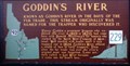 view gallery view galleryNE39.9 km |  Goddin's River Goddin's River
in Idaho Historical Markers Known as Goddin's River in the days of the fur trade. This stream originally was named for the trapper who discovered it. posted by: muddawber location: Idaho date approved: 04/14/2007 last visited: 09/24/2010 |
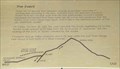
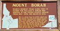 view gallery view galleryNE40.2 km | #45 - Mount Borah in Idaho Historical Markers Idaho History Sign #45 about Mount Borah. posted by: Volcanoguy location: Idaho date approved: 08/06/2011 last visited: 05/17/2017 |
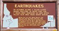 view gallery view galleryNE40.2 km | #356 - Earthquakes in Idaho Historical Markers Idaho History Sign #356 about the Borah Peak Earthquake. posted by: Volcanoguy location: Idaho date approved: 08/06/2011 last visited: 05/17/2017 |
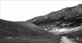
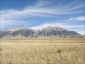 view gallery view galleryNE40.2 km | Mount Borah View - Idaho in Scenic Roadside Look-Outs View point and signs for Mount Borah and the Borah Peak Earthquake. posted by: Volcanoguy location: Idaho date approved: 07/27/2011 last visited: 05/17/2017 |
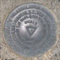 view gallery view galleryNE42.6 km | PZ0616 - USCGS DICKEY, Idaho in U.S. Benchmarks U.S. Coast & Geodetic Survey triangulation station DICKEY. posted by: Volcanoguy location: Idaho date approved: 07/27/2011 last visited: 09/24/2010 |
 view gallery view gallery E43 km E43 km
| KAY 2 NO 3 - Custer County, Idaho in U.S. Benchmarks Reference mark 3 for triangulation station KAY 2, located near Mackay Reservoir. posted by: Tom.dog location: Idaho date approved: 12/23/2022 last visited: never |
 view gallery view galleryE43 km | KAY NO 2 - Custer County, Idaho in U.S. Benchmarks Reference mark 2 for triangulation station KAY 2. posted by: Tom.dog location: Idaho date approved: 12/23/2022 last visited: never |
 view gallery view galleryE43 km | KAY 2 (OY0985) - Custer County, Idaho in U.S. Benchmarks A triangulation station on the southwest side of U.S. Highway 93, near Mackay Reservoir. posted by: Tom.dog location: Idaho date approved: 12/23/2022 last visited: never |
 view gallery view gallery N43.6 km N43.6 km
|  Beaverhead Crater, Idaho Beaverhead Crater, Idaho
in Impact Craters Beaverhead Crater is an impact structure located in central Idaho around the Challis area. posted by: Rose Red location: Idaho date approved: 07/21/2007 last visited: never |
 view gallery view galleryNE44.1 km |  Borah Peak Earthquake Scarps Borah Peak Earthquake Scarps
in Places of Geologic Significance Borah Peak Earthquake Scarps on Double Springs Pass Road. posted by: Volcanoguy location: Idaho date approved: 07/27/2011 last visited: 05/17/2017 |
 view gallery view galleryNE44.1 km | Earthquake! - The Event in Idaho Historical Markers One of a group of three signs on the Double Springs Pass Road. posted by: Volcanoguy location: Idaho date approved: 08/19/2011 last visited: 05/17/2017 |
 view gallery view galleryNE44.1 km | Earthquake! - The Results in Idaho Historical Markers One of a group of three signs on the Double Springs Pass Road. posted by: Volcanoguy location: Idaho date approved: 08/19/2011 last visited: 05/17/2017 |
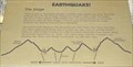 view gallery view galleryNE44.1 km | Earthquake! - The Stage in Idaho Historical Markers One of a group of three signs on the Double Springs Pass Road. posted by: Volcanoguy location: Idaho date approved: 08/21/2011 last visited: 05/17/2017 |
 view gallery view galleryNE45.7 km | PZ0458 - USCGS T15, Idaho in U.S. Benchmarks U.S. Coast & Geodetic Survey benchmark T15. posted by: Volcanoguy location: Idaho date approved: 07/27/2011 last visited: 09/24/2010 |
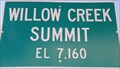 view gallery view galleryNE45.7 km |  7160 Ft - Willow Creek Summit - Idaho 7160 Ft - Willow Creek Summit - Idaho
in Elevation Signs Elevation sign at Willow Creek Summit. posted by: Volcanoguy location: Idaho date approved: 07/26/2011 last visited: 09/24/2010 |
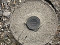
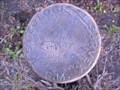 view gallery view gallerySW47.5 km | Dollarhide Summit Benchmark in U.S. Benchmarks USGS Benchmark Disk located at the top of Dollarhide Summit, near Ketchum Idaho. posted by: 1450Crew location: Idaho date approved: 06/20/2009 last visited: never |
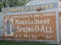 view gallery view galleryE48.9 km |  Mountaineer Spring-O-All - Mackay, Idaho Mountaineer Spring-O-All - Mackay, Idaho
in Ghost Signs Ghost signs on old building on S. Main Ave, in Mackay, Idaho. posted by: Volcanoguy location: Idaho date approved: 07/26/2011 last visited: 09/24/2010 |
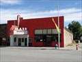 view gallery view galleryE48.9 km |  Main Theater - Mackay, Idaho Main Theater - Mackay, Idaho
in Vintage Movie Theaters The Main Theater on S. Main Ave, in Mackay, Idaho. posted by: Volcanoguy location: Idaho date approved: 07/26/2011 last visited: 09/24/2010 |
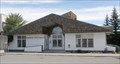 view gallery view galleryE48.9 km |  Mackay, Idaho Mackay, Idaho
in City and Town Halls City Hall for the community of Mackay, Idaho. posted by: Volcanoguy location: Idaho date approved: 07/26/2011 last visited: 09/24/2010 |
|