 view gallery view gallery S0 km S0 km
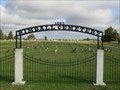
|   Kimball Veterans Memorial, Kimball, South Dakota Kimball Veterans Memorial, Kimball, South Dakota
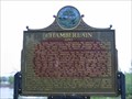
in Non-Specific Veteran Memorials Local memorial to all Veterans located in Hanton City Park, Kimball, SD posted by:  NGComets NGComets location: South Dakota date approved: 05/15/2009 last visited: never |
 view gallery view gallery N0 km N0 km
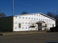
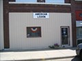
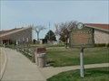
|  "American Legion Post 130", Kimball, South Dakota "American Legion Post 130", Kimball, South Dakota
in Legion Posts and Branches Small town American Legion Post, called Drips American Legion Post 130. posted by: NGComets location: South Dakota date approved: 08/20/2009 last visited: never |
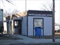
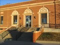
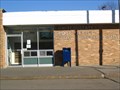 view gallery view galleryN0.2 km |  Kimball, South Dakota 57355 Kimball, South Dakota 57355
in U.S. Post Offices Small town post office. posted by: NGComets location: South Dakota date approved: 04/14/2009 last visited: never |
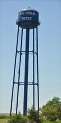
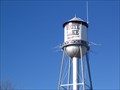
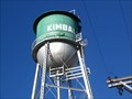 view gallery view galleryN0.6 km |  Watertower, Kimball, South Dakota Watertower, Kimball, South Dakota
in Water Towers An unusual watertower on the north side of town. posted by: NGComets location: South Dakota date approved: 02/17/2009 last visited: 09/27/2015 |
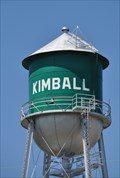 view gallery view galleryN0.6 km |  OR0841 ~ KIMBALL WATER TANK OR0841 ~ KIMBALL WATER TANK
in U.S. Benchmarks This survey mark is the top center of the water tower located on the north side of Votman Street just northwest of the intersection with Main Street on the northern edge of Kimball, South Dakota. posted by: brwhiz location: South Dakota date approved: 02/05/2013 last visited: 02/10/2023 |
 view gallery view galleryS0.8 km |  Kimball, South Dakota ~ Population 700 Kimball, South Dakota ~ Population 700
in Population Signs This Population Sign is on the east side of Main Street just north of the Interstate Highway 90 Exit 284 interchange at the southern town limits of Kimball, South Dakota. posted by: brwhiz location: South Dakota date approved: 12/18/2012 last visited: never |
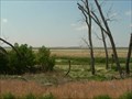
 view gallery view galleryS1.1 km |  St. Margaret's Cemetery, Kimball, South Dakota St. Margaret's Cemetery, Kimball, South Dakota
in Worldwide Cemeteries Medium-sized Catholic cemetery just south of the town of Kimball, South Dakota. Elevation 1767 posted by: NGComets location: South Dakota date approved: 10/24/2018 last visited: never |
 view gallery view gallery W1.1 km W1.1 km
| Kimball Cemetery, Kimball, South Dakota in Worldwide Cemeteries Medium-sized Protestant cemetery just west of the town of Kimball, South Dakota. Elevation 1778 posted by: NGComets location: South Dakota date approved: 10/22/2018 last visited: 10/13/2023 |
 view gallery view galleryS1.8 km | A-B Rural Water System Tower in Water Towers This water tower is located in an open field about 1/2 mile due south of Kimball, South Dakota. posted by: brwhiz location: South Dakota date approved: 02/06/2013 last visited: never |
 view gallery view galleryW18.3 km | Pukwana, South Dakota 57370 in U.S. Post Offices Small town post office. posted by: NGComets location: South Dakota date approved: 04/14/2009 last visited: never |
 view gallery view galleryW18.3 km |  Red Lake Red Lake
in U.S. National Natural Landmarks Red Lake is one of the largest remaining natural and unmanipulated prairie pothole lakes.
posted by: plainsdrifter358 location: South Dakota date approved: 07/08/2006 last visited: 06/13/2006 |
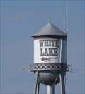 view gallery view gallery E19.6 km E19.6 km
| OR0838: WHITE LAKE WATER TOWER, White Lake SD in U.S. Benchmarks This Benchmark is the watertower at Main Street and Division Avenue in White Lake, South Dakota. posted by: PeterNoG location: South Dakota date approved: 11/09/2016 last visited: 02/10/2023 |
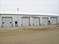 view gallery view galleryE19.6 km |  White Lake Fire Dept. White Lake Fire Dept.
in Firehouses Small town fire department. posted by: NGComets location: South Dakota date approved: 05/25/2010 last visited: never |
 view gallery view galleryE19.6 km | Watertower, White Lake, South Dakota in Water Towers Small town watertower. posted by: NGComets location: South Dakota date approved: 02/17/2009 last visited: 02/18/2023 |
 view gallery view galleryE19.8 km | "American Legion Post 96" White Lake, South Dakota in Legion Posts and Branches Goeres-Doering American Legion Post 96, a small American Legion Post. posted by: NGComets location: South Dakota date approved: 09/01/2009 last visited: never |
 view gallery view galleryE19.8 km | White Lake, South Dakota 57383 in U.S. Post Offices Small town post office. posted by: NGComets location: South Dakota date approved: 04/14/2009 last visited: never |
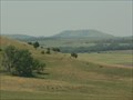 view gallery view gallery SW26.7 km SW26.7 km
| Bijou Hills in U.S. National Natural Landmarks Bijou Hllls in Charles Mix County, SD, consisting of an erosional remnant of soft clays and shales capped by a channel sandstone and quartzite. posted by: plainsdrifter358 location: South Dakota date approved: 07/08/2006 last visited: 06/02/2011 |
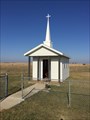 view gallery view galleryE27.8 km |  Corsica Christian and Grace Reformed Waychapel Corsica Christian and Grace Reformed Waychapel
in Waychapels A waychapel at an Interstate rest area. posted by:  ronjean ronjean location: South Dakota date approved: 11/27/2017 last visited: never |
 view gallery view galleryW28.5 km |  Ft. Ridgley & South Pass Federal Wagon Road ~ 1st Road in Dakota circa 1857 Ft. Ridgley & South Pass Federal Wagon Road ~ 1st Road in Dakota circa 1857
in South Dakota Historical Markers First road in South Dakota - Fort Ridgley and South Pass Federal Wagon Road opened in 1857. posted by: plainsdrifter358 location: South Dakota date approved: 07/08/2006 last visited: 06/13/2006 |
 view gallery view galleryW30.6 km | Chamberlain, South Dakota 57325 in U.S. Post Offices Small city post office. posted by: NGComets location: South Dakota date approved: 04/14/2009 last visited: never |
 view gallery view galleryW30.7 km | Chamberlain ~1880~ in South Dakota Historical Markers Named for Selah Chamberlain, a Milwaukee RR official, the site was the scene of an encounter between Jean Baptiste Trudeau and the Teton Sioux in 1794 and when Samuel H Morrow surveyed the area, in 1868 he found a ranch on American Creek. posted by: MNSearchers location: South Dakota date approved: 05/06/2007 last visited: 05/06/2007 |
 view gallery view galleryW30.9 km | Civilian Conservation Corps Camps in South Dakota Historical Markers HM commemorating the CCC, a Federal work-relief program during the great depression (1933 to 1942). posted by: plainsdrifter358 location: South Dakota date approved: 04/16/2006 last visited: 10/01/2016 |
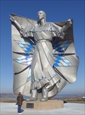 view gallery view galleryW30.9 km |  Dignity — Chamberlain, SD Dignity — Chamberlain, SD
in Figurative Public Sculpture Native American woman personifying dignity. posted by: ronjean location: South Dakota date approved: 11/20/2017 last visited: 09/17/2023 |
 view gallery view galleryW30.9 km |  Lewis & Clark - Chamberlain SD - 1718 ft. Lewis & Clark - Chamberlain SD - 1718 ft.
in Elevation Signs Elevation of 1718 feet is specified on the bronze sign which explains the round marker. posted by: Telomere location: South Dakota date approved: 09/09/2016 last visited: 09/28/2018 |
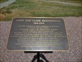
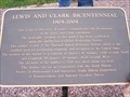 view gallery view galleryW30.9 km |  43d 47m 13.66s N 99d 20m 18.16s W - Chamberlain, SD 43d 47m 13.66s N 99d 20m 18.16s W - Chamberlain, SD
in Permanent Geographic Coordinates Lewis and Clark Bicentennial Sign at a Chamberlain, SD rest stop. posted by: Team 57 location: South Dakota date approved: 06/18/2010 last visited: 09/28/2018 |
|