 view gallery view gallery SE1.9 km SE1.9 km
|   Alpine Junction Wyoming Alpine Junction Wyoming
in Web Cameras Junction of highways 89 and 26 posted by:  DCJ DCJ location: Wyoming date approved: 03/26/2007 last visited: 07/23/2012 |
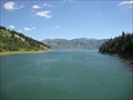
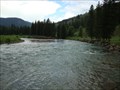
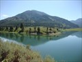 view gallery view gallerySE2.6 km |  CONFLUENCE - Grays River - Snake River CONFLUENCE - Grays River - Snake River
in River Origins, Destinations and Confluences Place where the Grays River meets the Snake River, and both flow into Palisades Reservoir. posted by:  Bittersweet Bittersweet location: Wyoming date approved: 07/24/2010 last visited: 08/29/2014 |
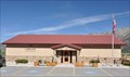 view gallery view gallery S2.6 km S2.6 km
|  Alpine Branch Library Alpine Branch Library
in Libraries This Library is a branch of the Lincoln County Library System. posted by: brwhiz location: Wyoming date approved: 09/10/2013 last visited: never |
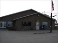
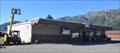 view gallery view gallerySE2.6 km |  Alpine, Wyoming 83128 Alpine, Wyoming 83128
in U.S. Post Offices This Contract Postal Unit is located in the Trailer Corral at 102 US Highway 89 in Alpine, Wyoming. posted by: brwhiz location: Wyoming date approved: 07/15/2013 last visited: never |
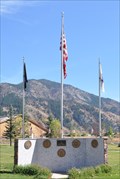 view gallery view gallerySE2.7 km |  Lyle F. Hansen Veterans Memorial Lyle F. Hansen Veterans Memorial
in Non-Specific Veteran Memorials This Veterans Memorial stands in the park near the center of Alpine. posted by: brwhiz location: Wyoming date approved: 09/11/2013 last visited: never |
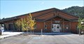 view gallery view gallerySE2.7 km |  Alpine Civic Center Alpine Civic Center
in Municipal Community Centers Alpine's Donn Wooden Civic Center is located on the main highway through town, across from the town park. posted by: brwhiz location: Wyoming date approved: 09/11/2013 last visited: never |
 view gallery view galleryS2.7 km |  The Astorians ~ Alpine, Wyoming The Astorians ~ Alpine, Wyoming
in Community Commemoration This monument on the southeast side of US Highway 89 at River Circle in Alpine, Wyoming celebrates two different events. posted by: brwhiz location: Wyoming date approved: 09/27/2012 last visited: 10/25/2022 |
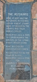 view gallery view galleryS2.7 km |  The Astorians The Astorians
in Wyoming Historical Markers This Historical Marker is located on the southeast side of US Highway 89 at River Circle in Alpine, Wyoming. posted by: brwhiz location: Wyoming date approved: 09/26/2012 last visited: 10/08/2012 |
 view gallery view galleryS2.7 km |  The Astorians Monument ~ Alpine, Wyoming The Astorians Monument ~ Alpine, Wyoming
in Civilian Conservation Corps This monument on the southeast side of US Highway 89 at River Circle in Alpine, Wyoming was originally built by the Civilian Conservation Corps. posted by: brwhiz location: Wyoming date approved: 10/10/2012 last visited: 10/25/2022 |
 view gallery view gallery W5.8 km W5.8 km
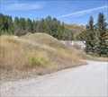
| DESTINATION: McCoy Creek - Palisades Reservoir in River Origins, Destinations and Confluences Destination of McCoy Creek as it meets Palisades Reservoir posted by: Bittersweet location: Idaho date approved: 07/24/2010 last visited: 10/25/2022 |
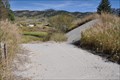 view gallery view galleryS7.1 km |  Salt River Hydroelectric Powerplant - Overflow Spillway - Etna, Wyoming Salt River Hydroelectric Powerplant - Overflow Spillway - Etna, Wyoming
in NRHP Historic Districts - Contributing Buildings The Overflow Spillway provided an escape route for excess water coming down the canal and not able to enter the Inlet Structure. posted by: brwhiz location: Wyoming date approved: 01/10/2011 last visited: 07/23/2012 |
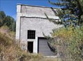 view gallery view galleryS7.1 km | Salt River Hydroelectric Powerplant - Powerplant Building - Etna, Wyoming in NRHP Historic Districts - Contributing Buildings The Powerplant Building, built in 1938 of concrete block, is the central structure of the power generating complex. posted by: brwhiz location: Wyoming date approved: 01/10/2011 last visited: 07/23/2012 |
 view gallery view galleryS7.1 km |  Salt River Hydroelectric Powerplant ~ Etna, Wyoming Salt River Hydroelectric Powerplant ~ Etna, Wyoming
in U.S. National Register of Historic Places The Salt River Hydroelectric Powerplant is an abandoned generating project from the 1930's. It was placed on the National Register of Historic Places on December 2, 1993. posted by: brwhiz location: Wyoming date approved: 01/10/2011 last visited: 07/23/2012 |
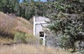
 view gallery view galleryS7.1 km | Salt River Hydroelectric Powerplant - Inlet Structure - Etna, Wyoming in NRHP Historic Districts - Contributing Buildings The inlet structure, built in 1938 of cast-in-place concrete, controlled the flow of water to the turbines. posted by: brwhiz location: Wyoming date approved: 01/10/2011 last visited: 07/23/2012 |
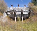
 view gallery view galleryS7.2 km | Salt River Hydroelectric Powerplant - Canal - Etna, Wyoming in NRHP Historic Districts - Contributing Buildings The Canal provided the pathway from the Diversion Dam (demolished) to the Powerplant. posted by: brwhiz location: Wyoming date approved: 01/10/2011 last visited: 10/25/2022 |
 view gallery view gallery E13.8 km E13.8 km
| CONFLUENCE - Little Grays River - Grays River in River Origins, Destinations and Confluences Place where the Little Grays and the Grays River meet east of Alpine, Wyoming. posted by: Bittersweet location: Wyoming date approved: 07/21/2010 last visited: 08/29/2014 |
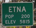 view gallery view galleryS16.4 km |  Etna, Wyoming - Northern Approach Etna, Wyoming - Northern Approach
in Population Signs Etna has an elevation almost 30 times its population! posted by: brwhiz location: Wyoming date approved: 03/22/2011 last visited: 05/28/2012 |
 view gallery view galleryS16.4 km |  Etna, Wyoming - Northern Approach Etna, Wyoming - Northern Approach
in Elevation Signs This sign pronounces the population and elevation of Etna as you enter town from the north on US Highway 89. posted by: brwhiz location: Wyoming date approved: 03/18/2011 last visited: 05/28/2012 |
 view gallery view galleryS16.9 km | Etna , Wyoming 83118 in U.S. Post Offices The little town of Etna has a Post Office at these coordinates. posted by: JacobBarlow location: Wyoming date approved: 09/13/2007 last visited: 09/13/2007 |
 view gallery view galleryS17.1 km |  Star Valley Community Complex Time & Temperature Star Valley Community Complex Time & Temperature
in Time and Temperature Signs This Time and Temperature Sign is in front of the Star Valley Community Complex located at 107736 US Highway 89 in Thayne, Wyoming. posted by: brwhiz location: Wyoming date approved: 08/29/2013 last visited: 10/25/2022 |
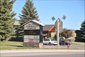
 view gallery view galleryS17.2 km |  The Baker Cabin The Baker Cabin
in D.U.P. Historic Markers This Historical Cabin and Marker is located on the west side of US Highway 89 between County Road 169 and Gravel Pit Road in Etna, Wyoming. posted by: brwhiz location: Wyoming date approved: 09/26/2012 last visited: never |
 view gallery view galleryS17.2 km | The Baker Cabin in Wyoming Historical Markers This Historical Cabin and Marker is located on the west side of US Highway 89 between County Road 169 and Gravel Pit Road in Etna, Wyoming. posted by: brwhiz location: Wyoming date approved: 09/26/2012 last visited: 10/25/2022 |
 view gallery view galleryS17.2 km |  First House in Star Valley with Shingled Roof and Wooden Floors First House in Star Valley with Shingled Roof and Wooden Floors
in First of its Kind The Baker Cabin was the first residence in Star Valley to have a shingled roof and wooden floors. posted by: brwhiz location: Wyoming date approved: 09/26/2012 last visited: never |
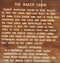 view gallery view galleryS17.2 km | First Permanent Residents on East Side of Salt River in Lower Star Valley in First of its Kind The Baker family were the first permanent residents on the east side of the Salt River in the lower Star Valley. posted by: brwhiz location: Wyoming date approved: 09/26/2012 last visited: never |
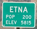 view gallery view galleryS17.5 km | Etna Wyoming - Southern Approach in Elevation Signs This sign pronounces the population and elevation of Etna as you enter town from the south on US Highway 89. posted by: brwhiz location: Wyoming date approved: 03/18/2011 last visited: never |
|