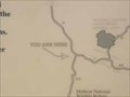
 view gallery view gallery N4.5 km N4.5 km
|   Diamond Lane & Hwy 205 - Oregon Diamond Lane & Hwy 205 - Oregon
in 'You Are Here' Maps You Are Here marker near junction of Diamond Lane & Ore Hwy 205. posted by:  Volcanoguy Volcanoguy location: Oregon date approved: 03/06/2011 last visited: 10/12/2010 |
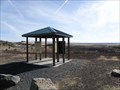
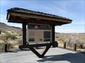 view gallery view galleryN4.5 km |  Diamond Loop Back Country Byway - Hwy 205 Kiosk - Oregon Diamond Loop Back Country Byway - Hwy 205 Kiosk - Oregon
in National Scenic Byways Informational kiosk for the Diamond Loop Back Country Byway located on Hwy 25. posted by: Volcanoguy location: Oregon date approved: 03/05/2011 last visited: 10/12/2010 |
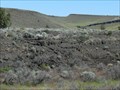
 view gallery view galleryN6.9 km |  Waterfowl at Malheur Wildlife Refuge - Buena Vista VP, Oregon Waterfowl at Malheur Wildlife Refuge - Buena Vista VP, Oregon
in Flora and Fauna Information Signs Flora and Fauna Signs at Buena Vista Viewpoint which overlooks the Buena Vista Ponds. posted by: Volcanoguy location: Oregon date approved: 03/03/2011 last visited: 10/12/2010 |
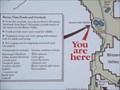 view gallery view galleryN7.4 km | Buena Vista - Oregon in 'You Are Here' Maps You Are Here marker at Buena Vista Overlook. posted by: Volcanoguy location: Oregon date approved: 03/01/2011 last visited: 10/12/2010 |
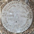
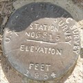 view gallery view galleryN9.5 km |  PA0166 - 1934 USCGS G315 - Oregon PA0166 - 1934 USCGS G315 - Oregon
in U.S. Benchmarks U.S. Coast & Geodetic Survey and State Survey benchmark G315. posted by: Volcanoguy location: Oregon date approved: 10/04/2011 last visited: 09/06/2010 |
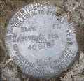
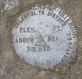 view gallery view gallery NE11.6 km NE11.6 km
| 1966 USGS 38BIS, Oregon in U.S. Benchmarks U.S. Geological Survey Elevation Mark 38BIS posted by: Volcanoguy location: Oregon date approved: 09/26/2011 last visited: 09/06/2011 |
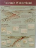 view gallery view galleryNE11.7 km |  Volcanic Wonderland Volcanic Wonderland
in Oregon Historical Markers History sign about the geology of Diamond Craters. The sign is located in the Diamond Craters kiosk on the Diamond Loop Back Country Byway. posted by: Volcanoguy location: Oregon date approved: 03/07/2011 last visited: 08/22/2017 |
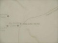 view gallery view galleryNE11.7 km | Diamond Craters - Oregon in 'You Are Here' Maps You Are Here marker at Diamond Craters. posted by: Volcanoguy location: Oregon date approved: 03/06/2011 last visited: 08/22/2017 |
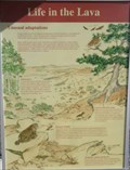 view gallery view galleryNE11.7 km | Life in the Lava - Diamond Craters, Oregon in Flora and Fauna Information Signs A Flora and Fauna Sign dealing with life in the lava beds of the Diamond Craters area. The sign is located in the Diamond Craters kiosk on the Diamond Loop Back Country Byway. posted by: Volcanoguy location: Oregon date approved: 03/05/2011 last visited: 08/22/2017 |
 view gallery view galleryNE11.7 km | Diamond Loop Back Country Byway - Diamond Craters - Oregon in National Scenic Byways Informational kiosk for the Diamond Craters Area. posted by: Volcanoguy location: Oregon date approved: 03/05/2011 last visited: 08/22/2017 |
 view gallery view galleryNE11.7 km |  Diamond Craters - Harney County, Oregon Diamond Craters - Harney County, Oregon
in American Guide Series Interesting volcanic formations in southeast Oregon posted by:  ddtfamily ddtfamily location: Oregon date approved: 10/14/2012 last visited: 08/22/2017 |
 view gallery view galleryNE13 km | 1966 USGS 39BIS, Oregon in U.S. Benchmarks U.S. Geological Survey Elevation Mark 39BIS posted by: Volcanoguy location: Oregon date approved: 09/26/2011 last visited: 09/06/2011 |
 view gallery view galleryNE15 km | 1966 USGS 40BIS, Oregon in U.S. Benchmarks U.S. Geological Survey Elevation Mark 40BIS posted by: Volcanoguy location: Oregon date approved: 09/26/2011 last visited: 09/06/2011 |
 view gallery view gallery S20.1 km S20.1 km
| Frenchglen, Oregon in American Guide Series Remote, historic southeast Oregon community at the foot of Steens Mountain posted by: ddtfamily location: Oregon date approved: 10/14/2012 last visited: never |
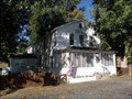 view gallery view galleryS20.1 km |  Frenchglen Hotel - Frenchglen, Oregon Frenchglen Hotel - Frenchglen, Oregon
in U.S. National Register of Historic Places The historic Frenchglen Hotel in Frenchglen, Oregon. posted by: Volcanoguy location: Oregon date approved: 03/03/2011 last visited: 09/09/2012 |
 view gallery view galleryNE20.9 km | 1966 USGS 43BIS, Oregon in U.S. Benchmarks U.S. Geological Survey Elevation Mark 43BIS posted by: Volcanoguy location: Oregon date approved: 09/26/2011 last visited: 09/06/2011 |
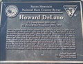 view gallery view galleryS21.4 km |  Howard DeLano - Steens Mountain Loop, Oregon Howard DeLano - Steens Mountain Loop, Oregon
in Citizen Memorials Memorial to Howard DeLano near the beginning of the Steens Mountain Loop Road. posted by: Volcanoguy location: Oregon date approved: 03/04/2011 last visited: 08/13/2011 |
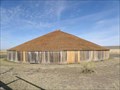 view gallery view galleryNE22.4 km | Diamond Loop Back Country Byway - Pete French Round Barn - Oregon in National Scenic Byways The historic Pete French Round Barn. posted by: Volcanoguy location: Oregon date approved: 03/06/2011 last visited: 11/27/2020 |
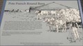 view gallery view galleryNE22.4 km | Pete French Round Barn in Oregon Historical Markers History sign about the Pete French Round Barn. The sign is located near the entrance to the fenced enclosure abound the barn. posted by: Volcanoguy location: Oregon date approved: 03/07/2011 last visited: 11/27/2020 |
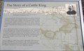 view gallery view galleryNE22.4 km | The Story of a Cattle King in Oregon Historical Markers History sign about the Pete French. The sign is located behind the Round Barn. posted by: Volcanoguy location: Oregon date approved: 03/07/2011 last visited: 11/27/2020 |
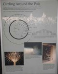 view gallery view galleryNE22.4 km | Circling Around the Pole in Oregon Historical Markers History sign about the Pete French Round Barn. The sign is located inside the barn near the entrance. posted by: Volcanoguy location: Oregon date approved: 03/07/2011 last visited: 09/09/2012 |
 view gallery view galleryNE22.4 km | French, Pete, Round Barn - Oregon in U.S. National Register of Historic Places The historic Peter French Round Barn north of Diamond, Oregon. posted by: Volcanoguy location: Oregon date approved: 03/07/2011 last visited: 09/09/2012 |
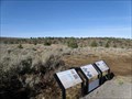 view gallery view galleryS27.2 km | Juniper Invasion - Steens Mountain Loop Road, Oregon in Flora and Fauna Information Signs Group of three Flora and Fauna Signs dealing with causes and effects of the increase in Juniper forests. posted by: Volcanoguy location: Oregon date approved: 03/05/2011 last visited: 08/13/2011 |
 view gallery view galleryS28.8 km | Juniper Management - Steens Mountain Loop Road, Oregon in Flora and Fauna Information Signs Group of three Flora and Fauna Signs dealing with testing methods of Juniper control. posted by: Volcanoguy location: Oregon date approved: 03/05/2011 last visited: 08/13/2011 |
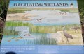 view gallery view galleryN29.3 km | Fluctuating Wetlands - Oregon in Flora and Fauna Information Signs This information sign is located in front of the Malheur National Wildlife Refuge Visitor Center. posted by: Volcanoguy location: Oregon date approved: 10/03/2011 last visited: 09/06/2011 |
|